Section 2 Out
Newchurch to Ruckinge
Walk Details
| Map | OS Explorer 125 Romney Marsh |
|---|---|
| Distance/Time | 5.5 miles/ 3 hours |
| Start | Newchurch Village Hall |
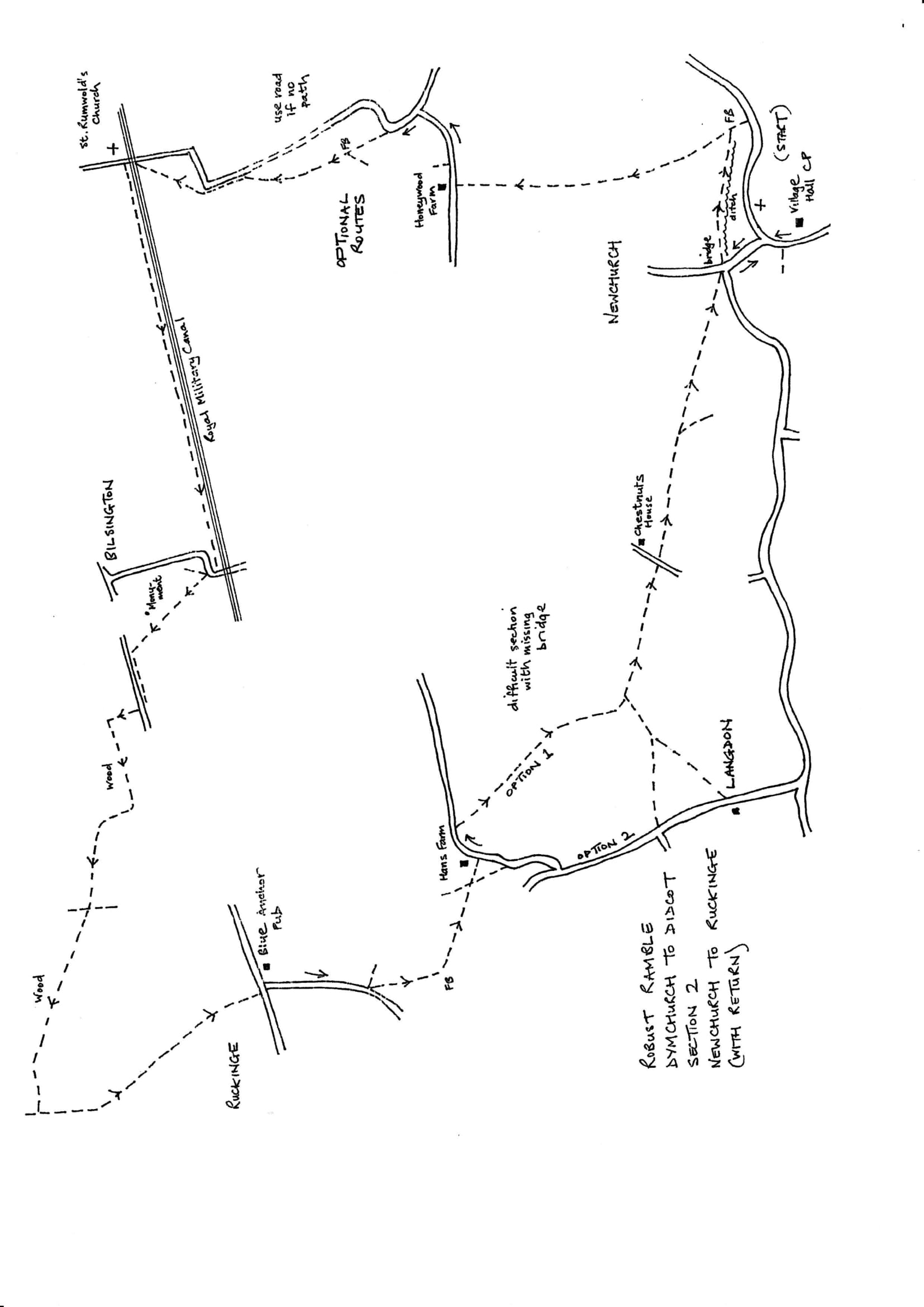
| Comment | A walk of contrasts from marshland to hilly woodland, but also demanding moments with poor stiles and paths not reinstated through growing crops. At the time of walking there were paths that were not evident on the ground. Three options are given to make the walk possible. Hopefully the situation will have improved. Enjoy the charming St. Rumwold's Church, the Royal Military Canal, plus excellent views of the marsh and the Cosway Monument. |
Walk Instructions
From Newchurch Village Hall Car Park turn right on the road. Walk along past a turning on the right then past a turning off left. Keep forward over a brick bridge and immediately turn right off the road over a footbridge and drop down into a field. Go ahead along the field edge with a drainage ditch down on the right.
At the end of the field, cross a wide footbridge into a further field. Immediately turn left up the side of the field with a ditch down on the left. At the top, go forward, still by the ditch, towards distant power lines. At the end of this field, cross an old footbridge into another field. Here turn diagonally right, away from the ditch, heading directly towards Honeywood Farm in the distance.
At a fence in mid-field cross a stile and continue on to emerge onto a road in front of the farmhouse. Turn right along the road.
At the moment the preferred route cannot be followed here as the path is unmarked and even the next path was unreinstated through crops and a footbridge was missing. Here are three options:
OPTION 1 These are the instructions if the paths have been reinstated.
From Honeywood Farmhouse turn right and walk along the road. There should be a footpath in a short distance going off left, opposite the first house on the right. It should go diagonally right, across two fields, to a footbridge by a bush (jump to asterisk).
OPTION 2 If Option 1 path is not visible.
From Honeywood Farmhouse keep on along the road to a T-junction of roads. Turn left here. Follow the road until it swings right. Here a footpath goes straight on into a field. Go forward (currently the path shows signs of being marked but is heavily overgrown) parallel to the hedge over on the right. At the top of the field reach a footbridge by a bush (continue at asterisk).
* Cross the bridge into a very large field (currently no marked path and heavily overgrown). Go forward aiming between two pylons in the distance and the tiny church of St. Rumbold in the far distance; this is where the path eventually leads. Keep forward across the field bearing slightly right. Notice a derelict barn on the right; a road runs in front of it. Pass the barn and head for the hedge on your right, at the point where power lines cross it, a little distance beyond the barn.
At this point the path should cross a bridge into the next field and continue along the side of the road, parallel to it, but with a ditch in between. However the bridge is missing, so leave the field by a gateway onto the road and turn left along the road. At a sharp righthand corner it should be possible to rejoin the path which crosses the field diagonally right to emerge at the bridge just below St. Rumbold’s Church. Currently, there is no trace of the path so continue along the road to a bridge over the Royal Military Canal. Continue from double asterisk.
OPTION 3 If none of these paths are reinstated.
To be certain of continuing the walk, pass Honeywood Farm on your left and continue along the road to a T-junction. Here turn left and walk along the country road for nearly a mile and a half to reach a bridge over the Royal Military Canal. Continue from the double star.
**Cross the bridge and turn left through a gate onto the broad grassy bank of the Royal Military Canal (RMC) Path (it’s worth visiting the church before turning here).
Follow the canal for a mile to emerge through a gate by Bilsington Bridge. Here leave the canal and turn right up the road. The road soon bends right. On the bend, look for a footpath through a hedge and on over a footbridge into a rising field.
Two paths start here. Bear slightly left and uphill to pass a pylon and also pass the impressive Cosway Monument in memory of a local landowner who died in 1834.
Past the monument the path bears more sharply left and downhill, passing the corner of a fence then on down to a road. The path does not exit onto the road but turns left along the hedge parallel to the road.
At the bottom of a dip two metal fieldgates are reached. Exit through these onto the road. Cross and turn left to walk along with care.
In a short distance look for a footpath going off right over a stile into a field. Cross and walk up the side of the field, away from the road, with a line of trees on your right.
Some way up the field the treeline bends slightly right. Here turn sharp left and walk straight across the field to cross a broken stile into a wood. Go forward uphill on a clear path.
Eventually this widens into an old vehicle track. Look out for a gap up on the right which indicates the end of the wood; the track swings right to stay in the wood.
By a waymark post, turn left off the main track, and go steeply uphill to a stile in a gap at the edge of the wood. Cross into a field and turn right along the edge with the wood on the right.
Some way along, when level with two isolated trees on the left standing in the field, bear diagonally left away from the wood to go to the very top lefthand corner of this large field.
Here enter the wood and drop down a bank to a stile. Cross the stile and a byway, to a footpath, over on the right, going forward into the wood. Keep on this clear path through woods for a quarter of a mile.
Eventually it joins an old vehicle track and bears right. Keep along for some 20 metres then turn off left through an arch of trees to a stile, broken again, into a field.
Cross straight over to a further stile and over this go ahead, straight up a pasture, to the very top. Here turn left along the top of the field with a hedge on the right.
At the next corner, cross a stile into the adjacent field and go downhill along the edge of the field (very overgrown) to reach a stile into the edge of a wood. There is a pond down on the left.
At the end of the wood, go through an old wooden fieldgate into a very large sloping field. Go on down in the same direction with a hedge and trees on the right. At the bottom corner cross a stile by wooden fieldgates into a pasture with buildings ahead. Continue down the pasture, past a little garden gate on your right, to a metal fieldgate. Go through onto a concrete roadway through farm buildings. Follow this concrete road all the way down to a T-junction with the main road through Ruckinge. Turn right to soon reach the Blue Anchor pub and the end of the outward section.