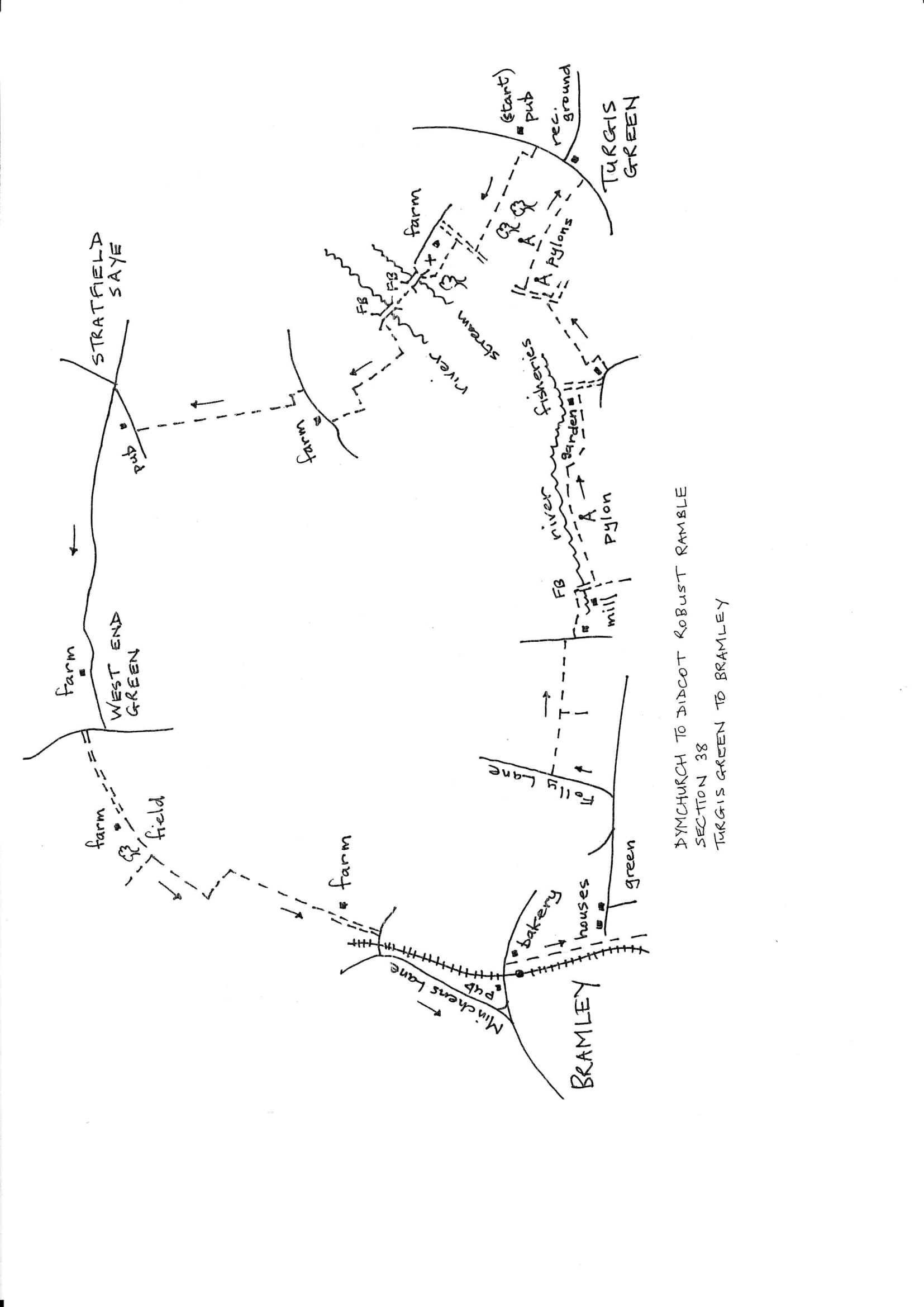
Section 38 Out
Turgis Green to Bramley
Walk Details
| Map | OS Explorer 159 Reading |
|---|---|
| Distance/Time | 6 miles/ 3 hours |
| Start | The Jekyll & Hyde pub in Turgis Green. |
| Comment | Generally easy field edges but some stretches of road walking. Be prepared for stiles in various states of repair. |
Walk Instructions
With the ‘Jekyll & Hyde’ pub on your left, walk down the main road. Go under power lines and pass the entrance to a recreation ground. Immediately look across the road for a gap in the hedge on the right (there is a wooden finger post). Cross with great care and go through the bushes to a footbridge.
Cross this and climb a bank. Turn right at the top through a gap into a corner of a field. Turn left to go up the edge of the field with a treeline on your left. At the end of the field bear right a few paces to a gap in the hedge. Go through and continue as before with the trees on your left.
Eventually reach a T-junction with a farm track. Turn right here down towards farm buildings. Just before the buildings turn left off the track along the bottom of the field to trees at the far side.
Go through a gap into the trees and cross a graveyard to an open grassy area by a ruinous church at Stratfield Turgis (sadly this is a medieval church with an interesting history and a failed conversion project). Cross the grass to a footbridge opposite the parking area.
Over the bridge go forward to a stile, and on, up a large pasture to a further stile and footbridge over the River Loddon. At the far side is another stile. Cross and bear diagonally left up a long pasture. Near the narrow top end look for a stile in the hedge on the right.
Cross with care as it is currently broken. Go forward by a fence and, ignoring a gate on the left, turn right through a gap into the corner of a field. Turn left up the side of the field with a hedge on your left.
Continue up a second field in the same way. At the very top the hedge turns sharply left; follow it around. Look for a wooden telegraph pole. Just before it, turn left through a gap into the next field. Immediately turn right to go down the field edge with the hedge on your right.
Leave the field by a metal fieldgate onto a road. Turn right along the road passing Ives Farm. Just past the main entrance turn left to a double metal fieldgate. Go through the wicket gate at the side into a field.
Turn left along the field edge with a hedge on your left. Soon reach a corner and swing right, uphill, still with the hedge on your left. Continue like this for some way to eventually exit via a squeeze stile by a double metal fieldgate onto a road. Turn right into Stratfield Saye village passing the Iron Duke pub. Just beyond is a road junction. Here turn left on a country road to West End Green. Unfortunately the footpath network is rather thin here so stay on the road for a mile. It’s not busy and the views and countryside are pleasant.
Reach a T-junction at West End Green, sadly a village which has lost both its shop and its pub. Turn right for 50 metres and then turn left by the village pond into the entrance to Lavell’s Farm and a massive security gate.
Walk up the drive. Pass the farm buildings over on your right. Where the drive swings right, go straight ahead on a green track along a field edge with a hedge on your right. Continue up past a wood on your right.
Where the wood ends keep on across the field ahead (currently reinstated through a crop). At the far side turn left then soon right through a gap into the corner of a field. Go down the field edge towards farm buildings. Join a drive and continue to a road.
At the road turn right and soon cross a railway bridge. Immediately turn left down Minchens Lane and follow this for ½ mile to reach a T-junction with a main road in Bramley. Turn left to reach ‘The Bramley’ pub and the end of the section.