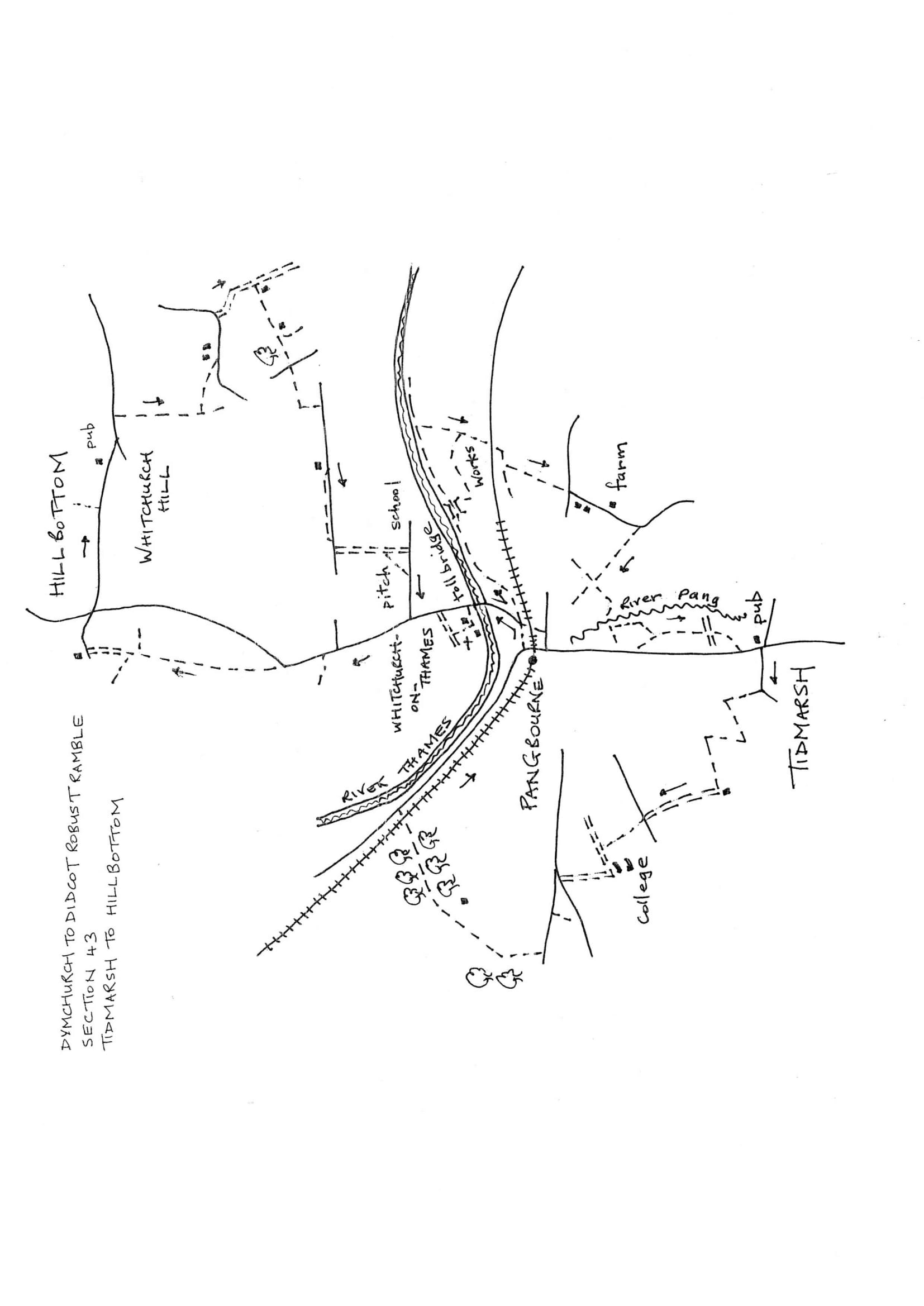
Section 43 Out
Tidmarsh to Whitchurch Hill
Walk Details
| Map | OS Explorer 171 Chiltern Hills West |
|---|---|
| Distance/Time | 7 miles/3.5 hours |
| Start | The Greyhound pub in Tidmarsh. There is nowhere to park in this village except the pub. Those doing the circular walk might park in Pangbourne (the Activity Centre by the River Thames is the best). |
| Comment | This is the only ‘figure of eight’ section on this ramble because of lack of bridges over the Thames. This section is full of contrasts with open country, dense woodland, historic interest in Whitchurch, then an easy country stroll to Whitchurch Hill. |
Walk Instructions
With ‘The Greyhound’ behind, cross the main road to Tidmarsh Lane and go up it passing a recreation ground on your left. Where the road bends left, turn right through a wooden kissing gate and go up the top side of a pasture with a fence on your left.
Go through a metal fieldgate in the top corner and go forward up another field, ignore a field entrance off left. Keep forward on a grassy track with a tree line on your left. At a corner follow the track sharp left and continue to the next corner. Here again stay on the track as it turns sharp right and drops to the bottom of the valley.
Go on up the next field with a hedge on your right. At the top corner turn left into a pleasant path enclosed between bushes. Follow this for some way. Eventually join a rough drive and bear right upto a road. Cross straight over and continue up a sandy drive.
Keep on up an obvious track between detached houses. Eventually emerge through a wooden fieldgate onto a roadway by garages. Continue up passing the garages on your left. At the top bear right to a T-junction.
Turn left here on a roadway between gateposts and soon reach a crossroads. Turn right and in a short distance bear left at a Y-fork. Pass two bungalows on your right and reach a wooden fieldgate and kissing gate. Go through and continue down an old road to a second fieldgate. Beyond keep going to reach a road junction.
Turn left up the higher road signposted to Upper Basildon for 150 metres. Pass the entrance to Lower Bowden Farm and continue uphill. Look for a gap in the hedge on your right. Go through this into the corner of a field. Go up the field with a hedge on your right to a corner of woodland.
Here turn right through a wide gap into a large pasture. Bear diagonally left across the centre with the wood on your left and a house over on the right. At the far opposite corner enter another field and turn right up the edge with a hedge on your right.
At the end of the field go through an old metal kissing gate into a wood. Bear right on a narrow path through the trees for half a mile. Halfway down the path broadens in a conifer plantation then narrows for the last stretch through mixed woodland again. Reach and go under a railway to a busy road. Cross and turn right. Walk along the pavement into Pangbourne with the River Thames on your left for 1 mile. Pass the entrance to Pangbourne Station. The road swings right towards a railway bridge. Do not go under but turn left on a side road called ‘The Wharf’.
This soon becomes a footpath by a tubular metal fence. The Thames is close and an impressive weir. Emerge onto a road by a surgery. Turn left to cross Whitchurch Toll Bridge, built back in the 18th. Century.
Just past the toll booth turn left up a gravel drive towards an old mill. Look for an enclosed path off right and follow this to a churchyard. Continue up passing Pangbourne Church on your left to emerge onto a drive. Turn right along to meet a road.
Turn left up the road for some way. Pass ‘The Greyhound’ pub on your right and keep on uphill between houses. After a very narrow stretch without a pavement, ignore the Thames Path turning off left, and cross over to a raised footpath running up the side of the main road now going steeply uphill.
Go up for some way. On reaching a war memorial, cross over to it and continue on uphill. Where the road swings right, keep straight on up a bank to a kissing gate into a field corner. Keep going up the side of the field with trees and a fence on your left.
At the top leave the field through another kissing gate into a narrow path enclosed between bushes. Leave this through a third kissing gate into a garden. Continue by a hedge on your left and soon reach a concrete drive.
Cross to a gate into a pasture and go up the side with a fence on your left. At the top exit through a gate into a wood. At a Y-fork in the middle of the wood, turn right through a kissing gate. At the top of the wood meet a rough farm track. Turn right on this and follow it beneath chestnut trees to wooden gates onto a road by a cottage.
Turn right along the road and soon roach a main road. Cross straight over and continue for half a mile to reach the Sun Inn at the far side of the village and the end of the section at Whitchurch Hill.