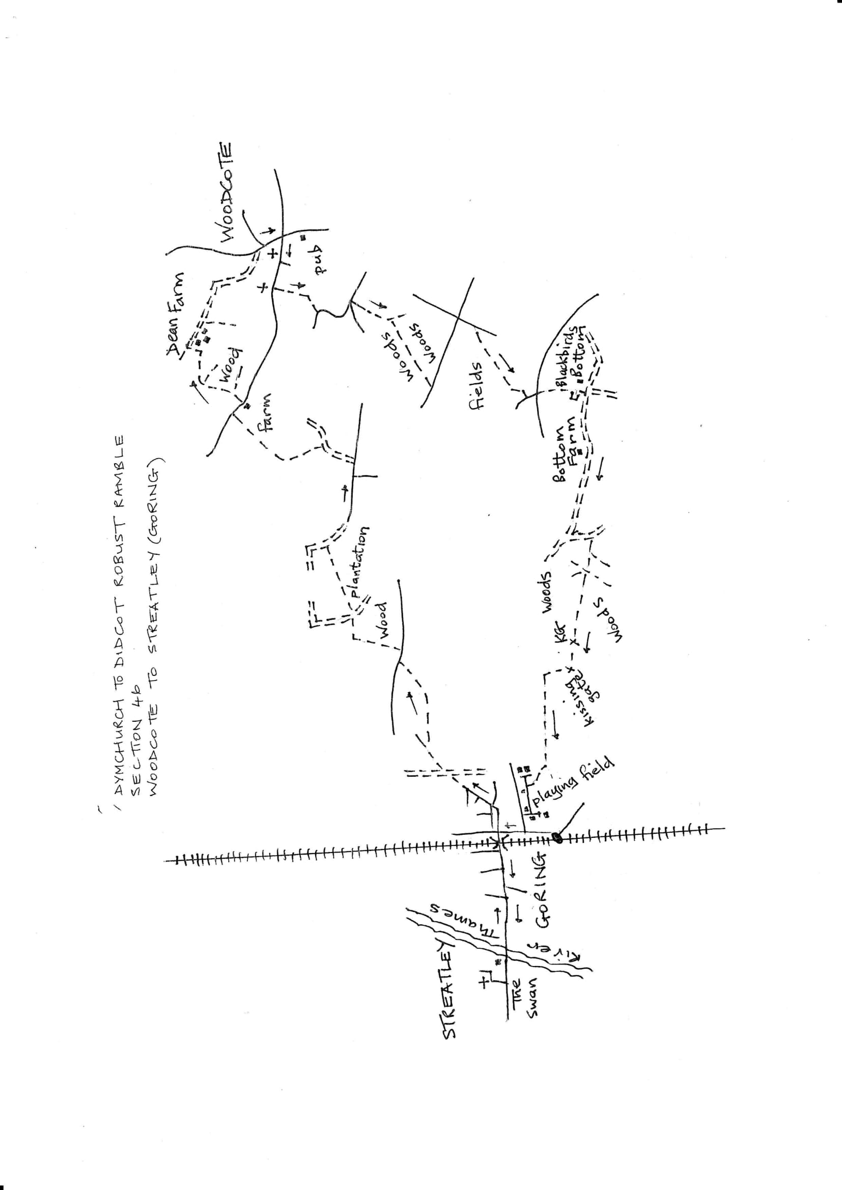
Section 46 Out
Woodcote to Goring (Streatley)
Walk Details
| Map | OS Explorer 171 |
|---|---|
| Distance/Time | 5 miles/ 3 hours |
| Start | The Red Lion in Woodcote; various parking possibilities in the vicinity of the War Memorial crossroads |
| Comment | An excellent and varied walk with excellent views of the Goring Gap on the final stage. This section is linked to the next by a long trek through Goring and over the Thames bridge to Streatley. This is an addition to the distances and times given for this section. This section officially ends near Goring Rail Station, there are currently no refreshment services here. |
Walk Instructions
With the Red Lion behind, turn left, back towards the War memorial crossroads. Turn left on South Stoke Road. Continue along for ¼ mile. Pass St. Leonard’s Church and ignore side turnings.
Look for an unusual black wood catholic church on your right, where housing thins out. Here turn left off the road on an enclosed path opposite by a rusty metal fieldgate and power lines pole.
Walk along to a metal kissing gate on your right. Go through and cross the corner of the field to a further metal kissing gate. Continue to a road.
Turn left on the road, passing a side turning, Wayside Green, and continue around to the next road junction. Here turn right down Wood Lane and go down to the bottom.
Go forward on a narrow enclosed path between fence and hedge. Soon reach a wood and a Y-fork. Bear right for some way through the wood to a wooden kissing gate onto a road at the far side. Turn left uphill on this. A pity there could not be a permissive path around the edge of the field on your right).
In 200 metres reach a junction with a main road. Turn right for 30 metres (there is a verge the other side). Soon leave the road and turn right through a wooden kissing gate.
Bear diagonally left across the field on a wide grassy way between new hedges. At the far side pass a rusty metal fieldgate onto an enclosed path leading to a drive by a beech hedge. Turn left to a road.
Cross straight over to a wooden kissing gate and on across the centre of a field. At the far side continue on an enclosed path. At the further end this twists to the right, around a house and garden and drops down steeply to meet a bridleway.
Turn right on this for ½ mile. Pass the isolated Bottom Farm, and keep forward on the bridleway, now more enclosed.
Go steadily down to a junction of bridleways near the bottom of the slope. Turn diagonally left to go back uphill on a narrow bridleway. In 40 metres meet a junction with a cross path which is part of the Chiltern Way. Turn right.
Soon reach a Y-fork and bear right. There are several forestry tracks in this area. At the next major junction, keep straight on on a path that remains on the level.
At the far side of the wood, exit through a wooden kissing gate (the start of excellent views from here) and walk descend to a further wooden kissing gate by a metal fieldgate. Go down and steeply up the field edge ahead with a hedge on your right.
Bear left at the field corner and continue with the hedge on your right along the top of the field, ignoring an unmarked wooden kissing gate soon reached.
After ½ mile by the hedge on the right, drop down to a field corner and a Y-fork of paths. Bear right, still on the Chilton Way, into a playing field, and bear diagonally left across it. Exit via a wooden kissing gate at the end of a long garden hedge, and follow an enclosed path to a road. Follow road around to the left and then zig zag right to reach a junction with a main road.
Turn left down to a T-junction and the Queen’s Arms pub (currently closed for renovation). Goring station can be seen just down on your left. Turn right uphill, to reach a junction, with a narrow road bridge going off left across the railway. This is the end of the section.
To continue into the next section or seek services, turn left over the bridge. To begin the return, turn right over the road with care.