Section 3 Return
Warehorne to Ruckinge
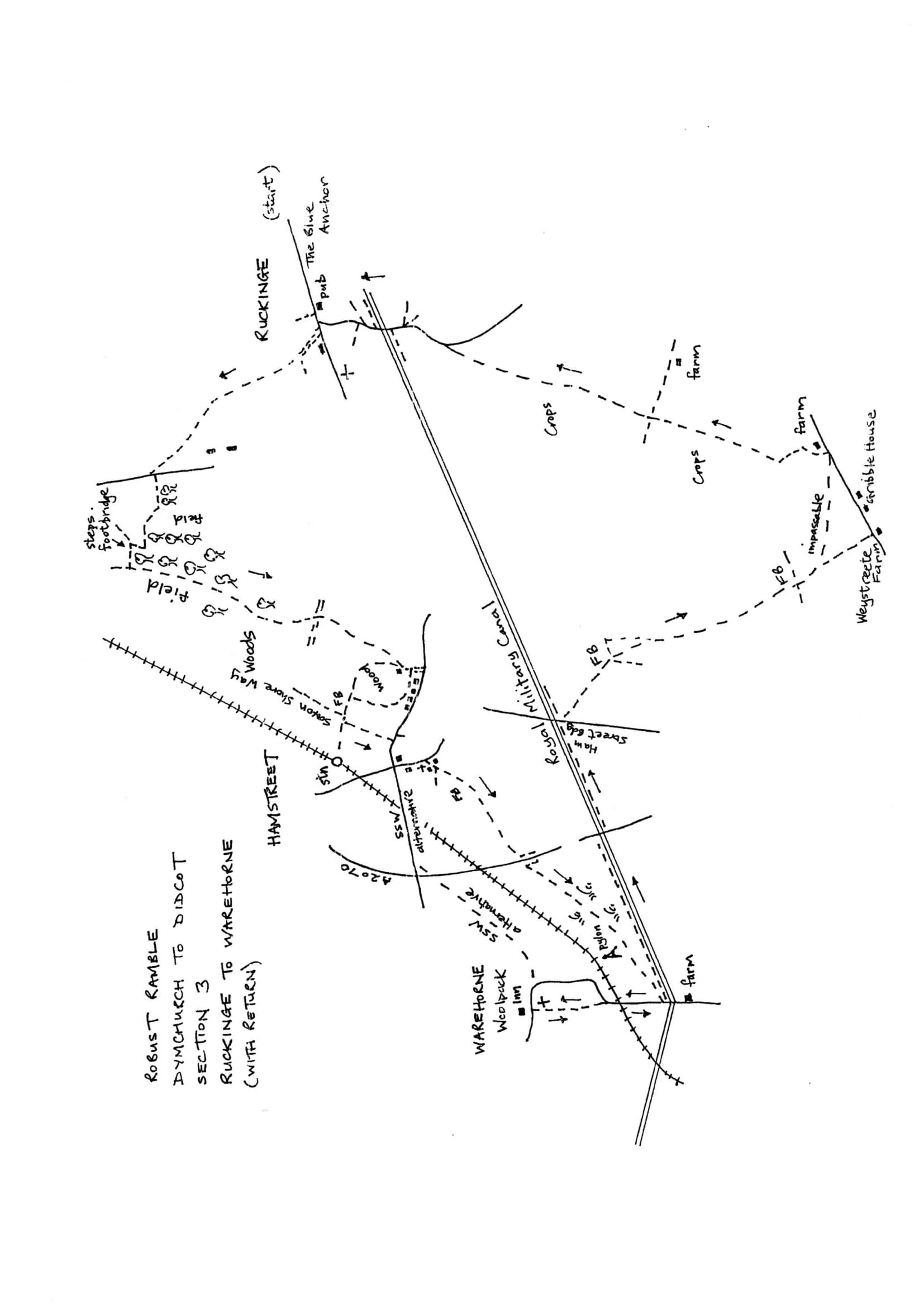
Walk Details
| Map | OS Explorer 125 Romney Marsh |
|---|---|
| Distance/Time | 5 miles/ 3 possibly 4 hours |
| Start | The Woolpack Inn and church in Warehorne |
| Comment | A walk of contrasts from marshland to intensive arable. The walking is challenging in a really robust way. These paths are little used and currently not reinstated through crops. The going can be tough and slow and needs constant map reading and direction checking. Pace may be reduced to 1 mph depending on the state of crops, so allow plenty of time. |
Walk Instructions
From the Woolpack Inn, cross back to the entrance to the churchyard opposite. Retrace the outward route back down the churchyard, past the tower, to a small gate. Go through and drop down the pasture to a stile at the bottom. Cross this to pass a house and emerge onto a road.
Bear right, to continue on down the road. Go under a railway bridge and on, to reach the Royal Military Canal. Do not cross the canal but turn left along the towpath with the canal on your right.
In ½ mile, at the next road bridge on the A2070, go onto the bridge and turn right over the canal. Immediately turn left down onto the towpath and continue with the canal now on your left for ¼ mile.
Pass under the next road bridge (Ham Street Bridge), and immediately turn right on a footpath going away from the canal. Cross the field to reach and cross a footbridge. Ignore a path straight ahead, instead, turn left along the field edge (the path should go diagonally left across the field but is marked out around the edge).
At a corner soon reached, turn right, to continue to follow the field edge with a hedge on the left. At the far corner the path should go on in the next field with a ditch on your right. However a waymark says, ‘please go along right side of ditch and cross back when possible’. So go on with the ditch on the left.
At the next gap, bear left across the ditch then bear right, to go forward on the proper course of the path, with the ditch and hedge on your right. After some way reach a footbridge at the end of the field.
The footbridge leads into a pasture ahead. ONCE AGAIN THE NEXT SECTION OF PATH IS HARD TO FIND AND MADE VERY DIFFICULT TO USE BY GROWING CROPS. IT WAS IMPOSSIBLE TO FIND THE INTENDED ROUTE TO BAINBRIDGE FARM (HM209)
From the footbridge look for a red tiled roof directly ahead at Weystreete Farm. This is where the path emerges. Go up the field towards the red roof. On approaching the top corner of the field look left for what looks like an old gate by the ditch on the left. This gate or section of wooden fencing marks a farm bridge over the ditch. Cross and bear right once more towards the red roofed house. THE PATH WAS JUST DISCERNABLE THROUGH RAPE BUT COMPLETELY OVERGROWN (HM207). Follow the path up to the top corner and cross a footbridge out to a road. Turn left along the road for 250 metres passing Gribble House on the right.
Soon reach a gateway on the left where two paths diverge just before Bainbridge Farm. THE ROUTE FOLLOWS THE RIGHTHAND PATH ALL THE WAY BACK TO RUCKINGE (HM206) BUT IS POORLY WAYMARKED FROM THE START AND SUBJECT TO MASSIVE CROP OVERGROWTH OF RAPE AND BROADBEANS.
Go through a homemade fieldgate and immediately cross left over a wire fence. Turn right to follow the wire fence. Where this swings right bear left across the field corner to a stile by another gate at the back of the farm.
Cross and go forward by the side of a barn. At the end of the barn turn left, away from buildings, on a grassy track which swings over to the right towards two fieldgates. Cross through the lefthand gate, a decrepit affair, then go over a ditch into a field.
Go ahead across the corner of the field to a gap in the hedge ahead. Keep going, bearing slightly left in this next field, to a footbridge at the far side. THERE WAS A TALL CROP OF BROAD BEANS HERE. THE PATH SEEMED ROUGHLY MARKED OUT BUT DID NOT EMERGE AT THE RIGHT POINT AT THE FAR SIDE. IT MAY BE NECESSARY TO CAST ABOUT TO FIND THE FOOTBRIDGE.
Over the footbridge, enter a large field. Cross, aiming straight ahead for a rusty metal fieldgate. Pass through and straight on, to a gap in the hedge ahead. Cross a footbridge into the next field. THIS FIELD HAD A RAPE CROP. THE PATH WAS JUST DISCERNABLE AS A DIP IN THE CROP BUT COMPLETELY OVERGROWN.
Cross, aiming for the monument at Bilsington in the distance. In midfield, cross a footbridge. FROM HERE THE PATH SHOULD GO DIAGONALLY RIGHT AIMING LEFT OF A RED BRICK HOUSE ACROSS THE FAR SIDE. HOWEVER THERE WAS NO PATH THROUGH A BROAD BEAN CROP.
From the footbridge go straight ahead along the field edge with a ditch on the left. In midfield reach a cross ditch. Here turn right towards a bungalow at the far side of the field.
Halfway along is the footbridge on the proper line of the path, minus its handrails. If it’s still not possible to regain the proper line of the path, proceed to the far side of the field and turn left along the edge of the field with a ditch on the right. Pass the red house and come to a footbridge on the right leading to a road.
Turn left up the road to cross the Royal Military Canal and go on up to a T-junction in Ruckinge. Here turn right a few paces to regain the Blue Anchor pub and the start of the section. THE AVERAGE WALKING SPEED TODAY WAS 1 MILE AN HOUR.