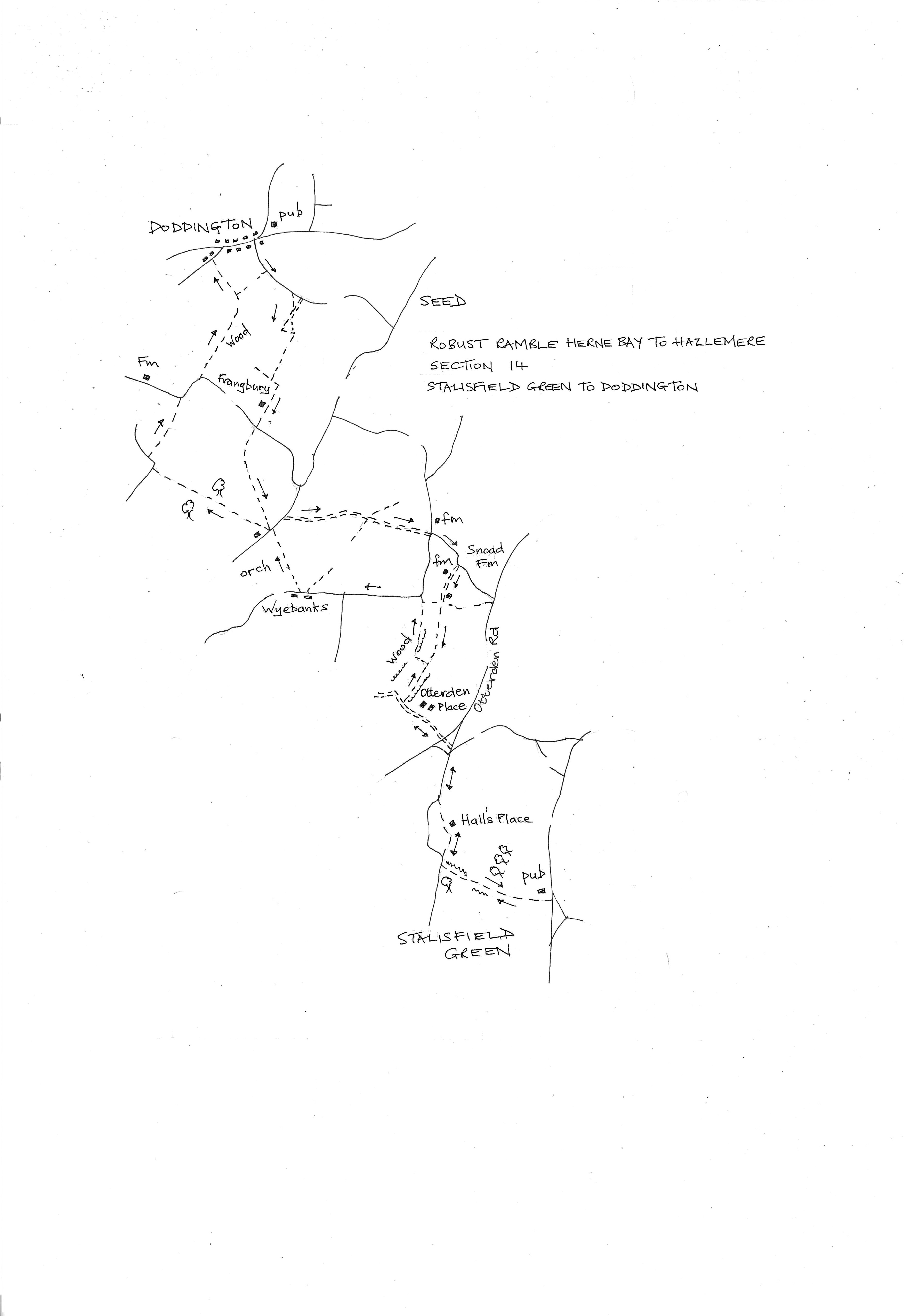
Section 14
Stalisfield Green to Doddington
Walk Details
Walk Instructions
Robust Ramble
Herne Bay to Hazlemere
Section 14 Out
Stalisfield Green to Doddington
OS Map: Explorer 137 Ashford, Headcorn and Wye
Total Circular Distance: 9 miles/6 hours
Start: Parking at the Plough Inn by arrangement or on road. The Inn has accommodation and a campsite but is not open on a Monday.
Comment: A varied walk with pasture and woodland paths, great rolling fields and impressive Otterden Place. This is very isolated countryside so make sure you have left details of your route.
From the car park of the Plough Inn turn right and walk across the grass at the front of the pub. Immediately past, turn right again down an enclosed footpath along the side of the pub.
The path soon emerges into a field. Keep forward up the side. The path then drops down and up again to enter the field ahead. Keep on up with the hedge on your left.
The track bears left through the hedge and continue in the same direction with the hedge now on your right. At the top corner go by a rusty fieldgate onto a road.
Turn right for 10 metres then bear right onto a gravel bridleway to Hall’s Place. Follow all the way round to meet a road at the end.
Turn right on the road, downhill for ¼ mile.
Arrive at a road junction. Ignore the road going sharply left. Instead, cross to a crumbling concrete drive going directly uphill towards white gates.
This meets a road at the top. Cross with care and go forward up the drive to Otterden Place. Go through the white gates and continue up past the house and outbuildings on your right.
Just past the last building, turn right to a metal kissing gate by a metal fieldgate under power lines.
Enter a long pasture and go forward with a fence on your right. Where the fence ends, bear left across the grass to another fence now on your left and continue up the pasture.
Where this fence turns sharp left follow it towards woods. At the bottom, by a metal fieldgate, find a wooden swing gate into the woods.
Go through and drop down a few paces to a holly bush on your right. Swing right here on a very feint woodland path. You are walking along a slope with high ground to the right and a narrow grassy pasture in the valley below. Stay on this contour for 200 metres.
At the end, where the grassy pasture below reaches its end, drop down to a more open are and go forward on a clearer path. Emerge onto a road. Turn left on it for ¼ mile uphill.
Pass a side road on the left and continue, to pass a flint cottage on your left (ignore the footpath opposite). Keep on uphill. Just before another cottage on the left, turn right, off the road into the corner of an orchard.
Go forward a few paces to metal arches marking a footpath across the orchard. At the far side emerge onto a road.
Cross to a gap in the hedge just right of a house entrance. Go through to a field corner and two paths. Take the lefthand path up the field edge with a hedge on your left (make a note of the corner just left).
Where the hedge ends go straight on down then up the open field to a corner at the top. Continue through a gap into the field ahead and go on with a hedge on the left.
Where this hedge ends go on up the open field to exit onto a road at the top.
Turn right a few paces to another footpath going back into the field on your right. Head across the open field towards a wedge of trees down in the distance at the far side.
On reaching the far side go through a gap in a short length of hedge onto a road.
Turn right along he road. In a short way, at the next bend, bear left, up the bank, into a field and turn right to follow the field edge and hedge on your right.
Keep up the field edge for some way. Follow the path as it bears right into a wood.
Leave the wood to go diagonally right across an open field to a gap in the hedge at the far side. Continue diagonally left across the next field then through the hedge and on down an open field towards the houses of Doddington below.
Exit down an enclosed path at the bottom onto a road. Turn right along to a T-junction then right again.
Keep along this main road passing a butcher’s shop. Reach a road junction with The Chequers Inn on the corner and the end of the section.
Robust Ramble
Herne Bay to Hazlemere
Section 14 Return
Doddington to Stalisfield Green
OS Map: Explorer 137 Ashford, Headcorn and Wye
Total Circular Distance: 9 miles/6 hours
Start: Parking at the Chequers Inn by arrangement or on road. The Inn is currently open every day.
Comment: A varied walk with some steep climbs. Good views, a little woodland and a long grassy pasture. This balanced with large arable fields, very flinty underfoot, and needing careful navigation. The final mile is on the outward route to avoid more road walking.
With the Chequers Inn behind, walk back down the main road to the butcher’s shop. Turn left up the side road for ¼ mile.
Ignore the first footpath off on the right and climb up and over the hill then on down. Notice the start of a wood on your right.
At the bottom of the hill (at a waymark pole) turn right, into the wood on a feint path.
Soon reach a forest tractor track. Turn right along it. After some distance reach a Y-fork with a rather ambiguous waymark disc. Either fork will do. I kept to the right on the tractor track and soon emerged at a field corner.
Here turn left up the field edge. At the top of the rise a post indicates where the official path comes up through the wood from the Y-fork.
At this point turn right to cross the large open field. Aim between pylons towards the left side of an isolated house at the far side.
On reaching the grounds of the house continue down the side passing the house on your right.
Join the house drive and turn left along it. At a T-junction with a road, turn right a few paces then left into another huge field.
Head down towards a wood below. 150 metres before reaching it turn diagonally left and continue down and across the field to the far bottom corner (this was where two paths diverged on the outward route).
Find the gap in the hedge and emerge on a road. Turn left along the road. In 100 metres turn right along a byway signed to ‘The Barn’. Follow this for ½ mile.
Halfway along the drive turns into a house on the right. Continue straight on along the edge of the field ahead.
After a time the path becomes a more defined track and winds down and up between fields (ignore a cross path).
Eventually pass a stable block and emerge onto Frith Road. Turn right along the road (ignore a side turning Wyebanks Road off right).
Round a sharp right bend, turn right through the buildings of Snoad Farm. At the end of the vehicle drive, go ahead through a metal fieldgate into a long pasture.
Go all the way down it. Halfway down meet a fence on your right around a cultivated plot. Keep on to reach a metal kissing gate by a metal fieldgate at the very end. This is back on the outward route.
Turn left on the drive past Otterden Place on your left. Go through white gates to cross a road and on down a rough concrete roadway to a T-junction at the bottom.
Ignore the first turning on the right and cross to the second one, Rigshill Road. Keep steeply up here for ¼ mile.
At the top turn left into the gravel bridleway passing Hall’s Place. At the end continue up the road a short way. Pass double metal fieldgates on your left to reach a rusty fieldgate just beyond.
Turn in here and follow the field edge with a hedge on your left. Soon the track bears left through the hedge and continues on with the hedge on your right.
Go steeply down I to another field at the bottom and on up the field beyond. The path continues up but enclosed between hedges to emerge by the Plough Inn in Stalisfield Green and the start of the section.