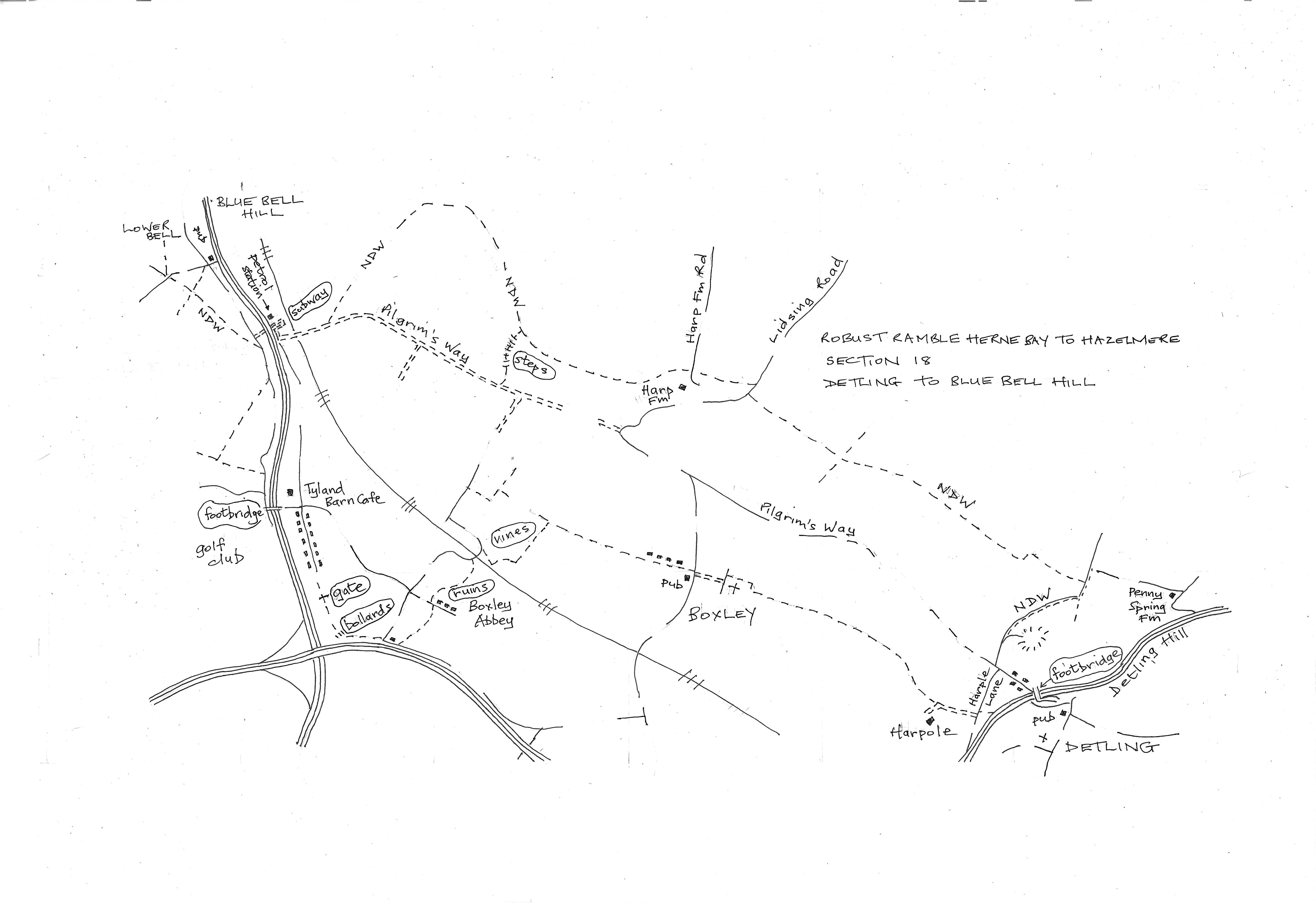
Section 18
Detling to Bluebell Hill
Walk Details
Walk Instructions
Robust Ramble
Herne Bay to Hazlemere
Section 18 out
Detling to Bluebell Hill (The Lower Bell)
OS Map: Explorer 148 Maidstone & the Medway Towns
Total Circular Distance: 8 miles/5 hours
Start: The Cock Horse pub in Detling, some parking here or on-road. Useful to know that there is a large layby near the Lower Bell for parking there.
Comment: Inevitably some steep climbs as the walk ascends to the North Downs Way (NDW) and drops down to return on the edge of the Weald below. The Lower Bell restaurant is only open Thursday to Sunday currently so it may not be necessary to visit if making the return or continuing into the next section. There is a café at Tyland Barn Centre about 20 minutes on the return.
With The Cock Horse pub behind, turn left to follow the road around the corner. Look out for the ramp to access Jade’s Crossing footbridge and cross the busy road down Detling Hill.
At the far side go straight along the Pilgrims Way. Pass Harple Lane on the left and in a few paces reach a Y-fork. Bear right on the road going uphill (NDW).
Where the road ends keep forward uphill up a rough track for ¼ mile.
At a junction of paths by a metal fieldgate near the top, go left (NDW). In 15 metres turn left to a low barrier between posts onto a narrow, enclosed path. Go ahead for ½ mile (ignore all side tracks).
Finally, at a Y-fork, go right to a road. Cross this, bearing right to a grassy bank, and walk a few paces to a gap in the hedge on the left. Enter a field and go forward along the edge.
Emerge on a road at Harp Farm. Cross to a footpath opposite. Pass the farm on your left and continue through a metal kissing gate for 1 mile.
Eventually, on a downward slope, meet a cross track. Here leave the NDW and turn left, downhill. Keep going to the very bottom, across a flatter space, to a footbridge and metal kissing gate onto the Pilgrims’ Way.
Turn right for 1 mile (ignore NDW coming in on the right again). Pass the White Horse Stone and then cross a railway bridge.
Reach buildings and go straight up a concrete roadway towards a petrol station. Just before, turn right on a road going steeply down and around to a subway under the main road up Bluebell Hill.
At the far side, turn left a few paces, down a side road. Look on the right, for an enclosed path on the NDW.
(IF INTENDING TO MAKE THE RETURN IMMEDIATELY, KEEP ON DOWN THE ROAD. LOOK FOR ‘QUICK START’ IN THE RETURN INSTRUCTIONS)
Otherwise turn right down onto the NDW path for 150 metres. At a cross path turn right, uphill through woods. Finally up steps to the side of a busy road. Turn right on a narrow path protected by a crash barrier to a road junction. The Lower Bell is opposite.
Robust Ramble
Herne Bay to Hazlemere
Section 18 return
Bluebell Hill (The Lower Bell) to Detling
OS Map: Explorer 148 Maidstone & the Medway Towns
Total Circular Distance: 8 miles/5 hours
Start: There is a large layby near the Lower Bell for parking. The pub/restaurant is only open Thursday to Sunday.
Comment: Inevitably some steep climbs as the walk scales the North Downs. Mostly field paths for this return. The way passes a café at Tyland Barn near the start of the return and the pub at Boxley is open every day. Interesting church at Boxley.
From the Lower Bell, cross to the road opposite going downhill. This return starts back along the outward route. Take the path on the lefthand side going down by a crash barrier. Soon turn left, away from the road, down steps and on, down through woods.
Meet a cross track (NDW) and turn left along to a side road below a raised dual carriageway. Turn right.
(QUICK START)
Go up the side road towards and past a pylon. At the bottom of this old road go straight through a metal kissing gate by a metal fieldgate. Continue diagonally right across a field.
Near the bottom reach a cross path and turn left. At the far end emerge on a side road and turn right. In 150 metres look for steps on your left up to a main road. Turn right to access a pedestrian bridge over the main road and cross.
At the far side join a road and go forward to a crossroads (Tyland Barn Wildlife Centre and café on left). Turn right down a road with a wide grass verge and trees with attractive Modern Movement houses on the right.
At the very bottom, where the road ends, continue down to bear left by a metal fieldgate (ignore a cycle overbridge off right).
Keep on along the path for some way. Finally, on through bollards to soon reach a road junction. Cross to go up Grange Lane opposite.
In 50 metres find a stile in the hedge on the left. Cross to a pasture and go diagonally right across it.
At the far side cross a high stile then through a garden gate into an enclosed area. Go forward by a fence on your left and on up to a row of houses.
Turn left along a road a few paces, then right, up the side of the end house. Follow an enclosed path to emerge at a corner of a vineyard. Bear right, along by hedge on the right.
At a corner bear left, up through vines towards power lines.
At the top go through the hedge and follow a narrow path through bushes for some way to eventually emerge on a road (this is an official path diversion). Turn right over a railway.
Soon turn right again through the hedge onto an enclosed path then down steps to a vineyard. Follow the edge.
After several turnings right and left, reach a broad, chalky cross track. Turn right for ¼ mile. Finally drop down past houses to emerge on a road at Boxley village. The Kings Arms pub is immediately right and the church over the road ahead.
Go up towards the church. Bear slightly left of the church wall to a stile into a pasture. Take the path keeping straight ahead along the church wall on your right.
At the back of the church, swing round to a stile and go forward across fields to a metal kissing gate by a metal fieldgate.
Emerge onto a gravel track and follow this for 1 mile. After a metal fieldgate the track becomes rougher.
Reach a double metal fieldgate by a farm and go forward to a concrete drive. This exits onto Harple Lane.
Turn left uphill (ignore a footpath off right across a field) for a ¼ mile to a junction with the Pilgrims Way. Turn right along to a main road. Cross the footbridge to Detling.
Turn right at the far side and follow the road back to The Cock Horse pub and the start of the section.