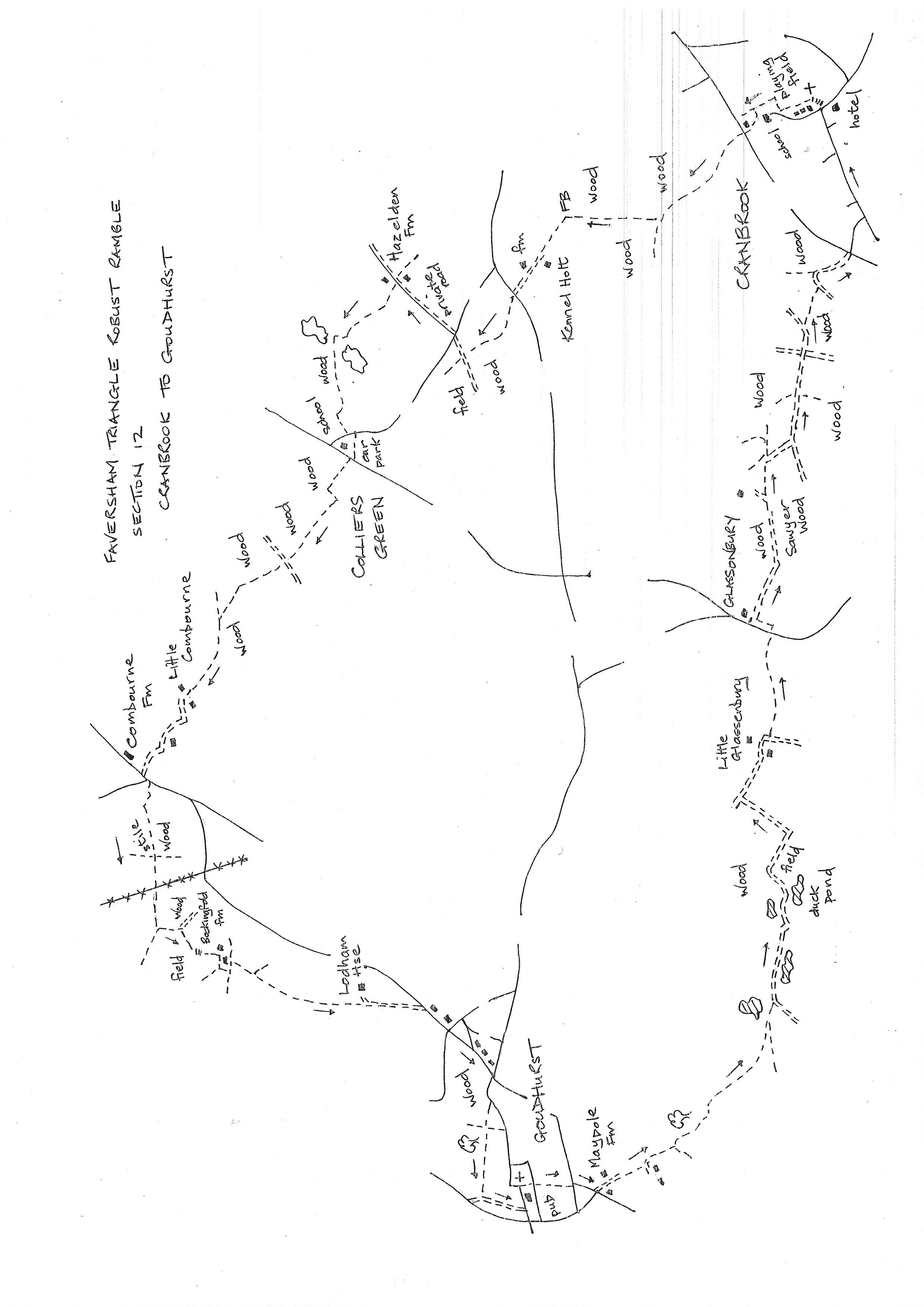
Section 12
Cranbrook to Goudhurst
Walk Details
Walk Instructions
Robust Ramble – Kent Triangle - Faversham – Wadhurst – New Romney – Faversham
Section 12 Out
Cranbrook to Goudhurst
OS Map: Explorer 136 Royal Tunbridge Wells
Total Circular Distance: 8 miles (4.5 hours)
Start: The George Hotel, Cranbrook, there is a FREE public car park off the High Street at the back of the Co-op.
Comment: A really delightful country walk. Undulating countryside with much woodland, plus grassland and open country with orchards. Enclosed paths may be overgrown in Spring and Summer, and paths may be muddy in Winter. There are stiles.
With the George Hotel behind, cross the road and turn left upto the corner. Go straight ahead, up the steps and on up the paved path passing the church.
At the top go straight up the tarmac drive passing school buildings on your left and a recreation ground on your right. The drive feeds in to an enclosed footpath which arrives at an open area at a school entrance.
Here turn sharp right along an enclosed path. This soon swings left and continues for some way. At the top of the rise, where the path opens out by an old swing gate, there is a Y-fork.
Turn sharply left along the edge of a grassy common. Follow the path as it swings down and across the grass towards a house on the bottom corner. Just before the house enter another enclosed path (there us a planning application for 35 new houses on this splendid piece of grass).
Reach and cross a main road and continue up the tarmac drive opposite, through gateways and on. At a metal kissing gate divert onto a footpath at the side if the drive with woods on your left and a hedge on the right (ignore paths off into the woods).
There is now a long and pleasant woodland path, albeit between wire fences. Go down then up passing an ultra modern movement house over on the left.
Near the top of the rise reach a Y-fork. Bear right. Keep on along an excellent woodland way for some distance. Drop down into a valley then up the other side. The path becomes a gravel drive and continues up to a main road.
Cross and go forward, up a narrow enclosed path for some way. Emerge onto a gravel drive. Turn right down to a road (not on OS map but waymarked).
Bear right across the road and turn left up a private road to Hazelden. Immediately before the first house on your left, turn left through a metal kissing gate and go down the edge of a field.
Through a second Metal kissing gate cross an open field to enter a third field and go on along the edge.
In the bottom corner, turn right through a gap and go on along the bottom edge of a field with a hedge on your left.
In a few paces turn left, out of the field, down a bank into trees. Cross a footbridge between lakes and go on up across grassland to enter a wood by a telegraph pole.
Soon leave the wood and continue along the edge of a large meadow. Emerge onto a road.
Turn left 10 metres then right, over a footbridge and over to a dusty parking area for the nearby school. At the top of the car park cross a stile onto a road. Bear right a few paces, then left, through metal fieldgates onto a broad grassy track.
Attghe top the track does a gentle dog-leg, left then right, then continues up along the edge of a large field with hedge on your right.
At the top corner enter woods and keep forward. Cross a forestry track midway and emerge onto vast field. Continue straight across.
Enter a wood at the far side and keep on to cross a footbridge. This leads to an enclosed footpath alongside a meadow.
Continue along the top edge of a second pasture, heading towards farm buildings. Dog-leg left and right through these buildings and head on down the entrance drive to meet a road. Turn left a few paces to a T-junction.
Bear across left to a footpath and stile by a telegraph pole. Cross into the foot of a meadow and continue to a second stile leading into an overgrown, enclosed path.
Reach a third stile into the bottom edge of a meadow and go along to the corner ahead (this could be a very boggy area).
Find and cross a stile. Ignore a cross path and go forward towards high power lines which you will need to go under. Reach the side of a large field.
The path goes straight and under the power lines, Find a tractor track or go around the bottom edge if the path is not reinstated through crops.
At the far side go through a gap in the hedge and turn left a few paces, down to a corner. Here turn left out of the field through a metal fieldgate, onto a broad, woodland track.
Soon reach a junction of ways. Turn right over a footbridge, then diagonally left up the centre of a rising field.
At the top cross a footbridge and climb steps to the field above. Go up the edge to the very top, passing farm buildings on your left.
Meet and turn left on a concrete track. This goes straight up to a field at the top of the rise. Turn left along the field edge, now skirting the top of the farm.
Soon turn right, still up the field edge (ignore bridleway off left). At the very top emerge through bollards onto a drive. Go down it to a road.
Turn right up this rather bland stretch of road for 100 metres, to a junction with a busy road at the top. Cross to continue up a narrow lane, again to the very top and a T-junction with a main road.
Turn right on the main road for a few paces then right, through a metal kissing gate onto a footpath across a grassy triangle. Ignore a cross path and enter a wood through a metal kissing gate.
Keep forward, ignoring all side paths, for some way, in and out of woods, finally dropping down a long enclosed path to a T-junction with a cross path with tall wooden fence ahead.
Turn left, uphill, for some way to emerge in the centre of Goudhurst. Cross to the Star & Eagle Hotel and the end of the section.
Robust Ramble – Kent Triangle - Faversham – Wadhurst – New Romney – Faversham
Section 12 Return
Goudhurst to Cranbrook
OS Map: Explorer 136 Royal Tunbridge Wells
Total Circular Distance: 8 miles (4.5 hours)
Start: The Star & Eagle Hotel in Goudhurst. Very difficult parking in the village. There is limited parking for hotel patrons, and a small free car park down a left turning just past the hotel.
Comment: Fairly straightforward to start with but very confusing in the woods after Glassonbury. Quite a lot of farm and woodland drives to walk along.
From the Star & Eagle turn right into the churchyard. Pass the church on your left and drop down to a narrow road.
Cross to an enclosed path going straight downhill. At the bottom go down steps to a road. Turn left a few paces to a junction, then right along the lower road to a further junction.
Here, turn left, down a private road to several named houses.
Halfway down the hill, go through a metal gate onto a dedicated footpath. Exit via a metal kissing gate. Cross a drive to continue downhill on a clear track. In 30 metres reach a Y-fork and turn left down a bank.
Follow an obvious grassy path along by trees and bushes on your left, to reach a footbridge. Over this climb up across an open field to a line of trees.
Go through these trees to cross a farm track, then footbridge, and continue along the edge of a further meadow with trees on your left.
At the top of the rise meet a farm track. Turn left on this (it goes virtually all the way to Glassenbury) and stay with it even if the right of way on the map initially takes a slight diversion.
Follow the track as it passes a pond on your left, then another in trees on the right, then another on the left, to finally reach a large pond (currently with hundreds of ducks) on your right.
Here bear left (the track is indistinct) along the bottom edge of a field to a corner. Turn right here back on a clear track, up between hedges.
At a junction of fields and tracks, by a telegraph pole, turn left, uphill. At the top of the rise, follow the track around to the right and keep on it. It becomes a drive into Little Glassenbury.
Immediately past the houses, turn left off the drive, into the corner of a field and go on down the edge with trees on your left.
Eventually cross a footbridge into the adjacent field and continue up the side, climbing steadily, to eventually emerge onto a busy road.
Cross to the footpath opposite. Turn immediately left along the edge of the field and soon reach a farm track along the side of farm buildings.
Turn right on this track, down, and into woods. Stay with the track as it bears left and uphill for some way.
Pass a sawmill on your right. Now bear slightly right onto a woodland footpath down to a crossing of several paths. Unfortunately the waymark post was broken.
Turn right up the main track going uphill, the High Weald Landscape Trail, and follow its occasional way marks. At the top of the rise reach a T-junction with a broad forestry track. Turn left on this for some way, keeping with HWLT waymarks. Ignore cross tracks.
Eventually, a HWLT waymark to your right, takes the trail off the forest track, onto a footpath up through trees. At the junction at the top is a tall wooden waymark post with the HWLT name cut vertically into the wood.
Here do NOT turn right but leave the High Weald Landscape trail. Turn left on a wide, forestry track, downhill. This track soon swings right. Stay with it for some way, soon to emerge on a road.
Cross, to continue down a side road, to emerge onto a main road.
Turn left into Cranbrook and stay on the road all the way back to the George Hotel and the start of the section.