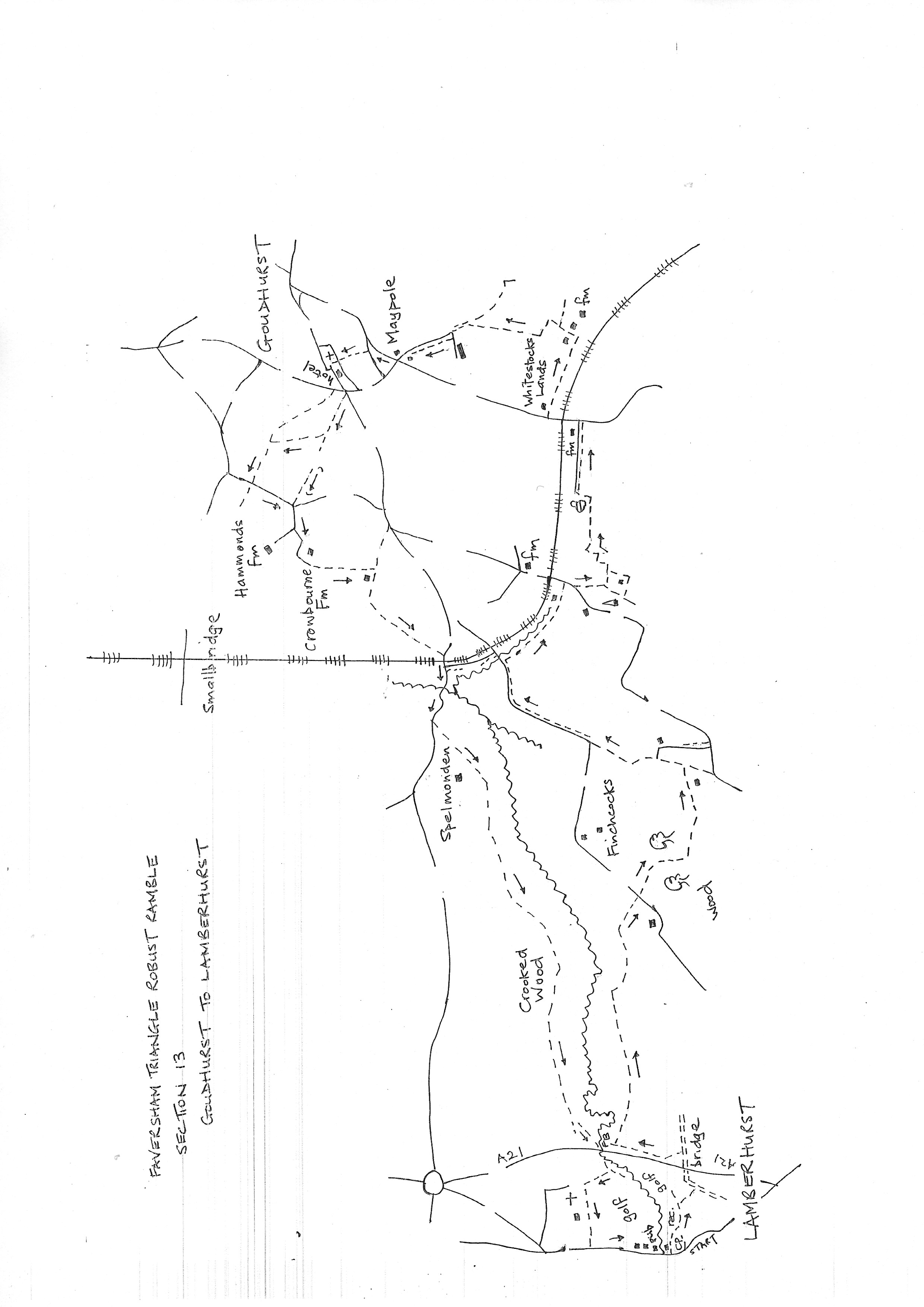
Section 13
Goudhurst to Lamberhurst
Walk Details
Walk Instructions
Robust Ramble – Kent Triangle - Faversham – Wadhurst – New Romney – Faversham
Section 13 Out
Goudhurst to Lamberhurst
OS Map: Explorer 136 Royal Tunbridge Wells
Total Circular Distance: 8 miles (5 hours)
Start: The Star & Eagle Hotel, Goudhurst. Parking is very difficult in the village. Just past the hotel is a turning left to a small free car park which is often full. A few side roads on the Lamberhurst side of the village.
Comment: An enjoyable country walk. Undulating countryside with woodland, grassland and excellent distant views. Enclosed paths may be overgrown in Spring and Summer, and paths may be muddy in Winter. There are stiles. The bridge crossing the River Teise has no pavement and the road is very busy. There is a narrow grass verge which makes the crossing possible but great care is needed.
With Star & Eagle on your left, walk downhill a short way a road junction. Cross to North Road and the old Bank building. To the left of the bank building, by a wooden telegraph pole, a tarmac drive goes steeply down. Go down this drive.
Where the drive bears right, go straight ahead, through a wooden kissing gate into an enclosed path. Emerge at the top of a grassy field. Follow a narrow path down through the long grass. It bears right as it drops and at the bottom turns right as it leaves the field to meet a grassy track, also descending the hill. Turn left on this clear track.
Soon reach a wooden kissing gate and footbridge into a meadow. Go down the edge to a third wooden kissing gate, and continue, still downwards, on an enclosed path. Emerge over a footbridge onto a road. Turn left.
In a short distance reach a left bend and a side road off right. Turn right and keep along past two houses on your left. Ignore a road off left to Hammond’s Farm and keep on the road which now becomes a rougher drive, bending left and right.
At the second left bend, by a hedge of copper beech, turn right onto a grassy path. At the end bear right onto a drive.
Stay on the drive to a T-junction with faded gates ahead. Ignore the first right turn down to a farm, and cross to a gravel track down through trees.
A few paces down, turn left over a stile by a wooden fieldgate, onto a grassy enclosed path.
Keep on for some way. Emerge into a meadow and keep on down the side. Leave at the bottom corner and cross a stile into the foot of a pasture. Go forward with a conifer hedge on your right.
At the end turn right through the trees to a stile. Then left along an enclosed path. Emerge at a metal fieldgate, and go round with great care to a VERY BUSY road without a pavement.
Carefully cross and turn right past a closed pub and an entrance to Finchcocks (also an information board about the Hop Pickers railway line which linked these local villages).
Again, carefully cross the road, to a narrow grass verge and continue over the River Teise bridge. New crash barriers have been installed on the bend which helps walkers a little.
At the end of the barriers, where the road starts to rise, cross over to a footpath going off through a metal swing gate by double metal fieldgates. Go straight down a concrete farm track.
Go through a gap in a hedge and continue past Spelmonden Farm and renovated hop pickers huts on your right.
Continue straight on across the field ahead to the far corner. Here, go straight on through a gap and keep forward along the edge of the field ahead. Reach a metal kissing gate in the hedge in the corner ahead.
Go through and cross a footbridge into a hay meadow. Bear slightly left across the meadow to the corner of a hedge at the far side.
Continue ahead, still along the edge of the meadow, just a few paces, looking for a metal kissing gate hidden in the hedge on your right.
Pass through and turn left along the bottom edge of a field, now with the hedge on your left.
Eventually reach a gravel farm track. Turn left on this for nearly a mile. After a rougher section the track continues in concrete.
At the end, nearing a main road, bear diagonally left across a field. At the far side join a narrow path into bushes. This soon meets a Y-fork. Turn right to go under the busy A21 alongside the River Teise.
At the far side emerge into a field. Turn right, uphill towards Lamberhurst Church. Enter the churchyard and turn left, passing the church on your right (if possible visit).
Soon continue on a broad metalled track across the top of a golf course. Keep on this for ¼ mile to emerge onto a road. Turn left downhill, into Lamberhurst, passing the George & Dragon to reach The Chequers and end of the section.
Robust Ramble – Kent Triangle - Faversham – Wadhurst – New Romney – Faversham
Section 13 Return
Lamberhurst to Goudhurst
OS Map: Explorer 136 Royal Tunbridge Wells
Total Circular Distance: 8 miles (5 hours)
Start: The Chequers in Lamberhurst
Comment: This is a walk of great contrast with fields, woods, riverside walks, views and hop picking heritage on offer. There are stiles and hills to climb. Some of the paths are rather obscure so allow plenty of time to find the way. Do not follow the waymarks (unfortunately the same yellow arrows as normal PROW waymark disks) of the Hop Pickers Trails from Scotney Castle.
Go down the side of The Chequers pub and restaurant. Just before the car park ahead, turn left, towards the pub garden. Bear right to go down a grassy path between a brickwall on your right and the fence of the pub garden on the left.
Follow the path into a playing field (the gate at the end of the car park also arrives here). Bear right, across the field to a childrens play area, turn left along the edge of the playing field, to the far corner by two bench seats.
Here turn right through trees to meet a golf course. Go straight across to a footbridge and gap in the hedge. Ignore path off left, and continue straight ahead. Cross the golf course to a second gap in a hedge.
Go through to a field and cross this to meet a tarmac drive. Turn left on this to go up and over the busy A21 highway.
Immediately over the main road, look for a footpath off left into trees (it’s necessary to step over a crash barrier). Soon reach the corner of a field. Go ahead down the side of the field with the noisy road on your left.
At the bottom corner of the field the path divides. Ignore the way ahead over a river bridge. Instead turn sharply right, up, and across the foot of the field to a large tree.
Go forward, straight across the foot of the field with the River Teise making broad meanders down on your left. At the far side cross a stile and continue straight across the field ahead.
Go through a swing gate into the next field and bear slightly diagonally right to a stile and gateway in the fence ahead.
On reaching these ignore them and continue on along the field edge with a fence on your right. At the far end of the field go through a metal fieldgate in to the corner of a Hop Garden. Bear right upto the top edge and continue along it.
At the end of the hops, exit through a metal fieldgate and bear diagonally left across a sloping pasture ( ignore the track upto the farm and also the ‘Hop Trail’ waymark off sharp left.
In the opposite bottom corner, cross an ancient stile by a metal fieldgate. Cross a farm track and continue along them bottom edge of the field ahead.
At the end exit through a metal fieldgate onto a farm drive. Turn left a few paces to cross a bridge. Immediately turn right into an enclosed path through a metal gate.
Immediately look for a wooden gate on your left into a rising pasture. Go through this gate, leaving the enclosed path, and bear right, steeply up the field, to a stile at the top into woods (a welcome seat here with extensive views).
Keep up through the woods to a stile by an old metal fieldgate. Cross into the corner of a field. Go up the side with a fence on your left, a short distance. At a tree, turn sharp left to cross a stile, then sharp right to a second stile into a long field.
Bear diagonally left across the field to the top edge. Turn along it, ignoring all gates off right. Keep along to the very end of the field, passing Riseden Farm on your right.
Find a stile hidden in the very end corner. Drop down steps through trees to a junction with a cross path. Turn left on this rather overgrown path, downhill. Eventually reaching a group of cottages.
Keep on downhill to soon reach a stile by a metal fieldgate. Cross and turn right to another stile and go diagonally left downhill to the far bottom corner.
Leave the field through a metal fieldgate in the corner and turn right on an asphalt drive for ¼ mile.
Just after crossing a brick bridge, and just before wooden telegraph poles and a second brick bridge, turn right over a stile by a rusty fieldgate into a field.
Go along the edge of the field with a stream on your left. The Hop Pickers railway line ran the other side of the stream.
Near the end of the field turn left through an unmarked swing gate with a footbridge beyond. Do NOT cross the bridge but turn sharp right up a vehicle drive to a road.
Turn right on the road as it drops downhill. At the foot of the slope, turn left through metal gates into the bottom corner of a field. Turn diagonally right to go up the field to a gap in the hedge at the top by a stand of trees (a house is well over on the right).
Go through a metal kissing gate in the gap in the hedge. Ignore the OS map here as the route does an unnecessary kink which is hard to find. Instead follow the route used by local walkers.
From the kissing gate turn sharp left along the edge of the field. At the corner ahead go through a gateway into the field ahead, rejoining the public path.
Turn left down the side of the field to the bottom corner then right, still along the field edge towards a tall treeline ahead (do not be tempted into the field on your left).
Just before the treeline turn left, through a white metal fieldgate and drop down to a concrete bridge. Cross and turn left down the field edge to the bottom corner.
Here turn right on a concrete farm track and go straight along it for ¼ mile to a road.
Turn left on the road (again no verge and flurries of speeding traffic) for a short distance, over a bridge. Turn first right into a driveway and cross a stile by a metal fieldgate.
Go along the edge of a paddock to a stile by a second metal fieldgate and continue with trees on your left.
Do not be tempted off left, but keep straight on to the next corner and a small stile. Continue in same direction to emerge through wooden fieldgates onto a drive.
Walk up the main drive (ignoring the rougher parallel track on the right). Eventually approach buildings. Cross a drive and go right up to the houses straight ahead – South Oast – and veer left on a driveway up and along the front of them.
Just past the buildings, turn right across a storage area and out at the top on a path by a tall wooden fence.
Soon go through a barrier to a Y-fork. Bear slightly left, up and overgrown path. This soon turns left onto a farm track.
Follow this track (partly of concrete railway sleepers) for ½ mile always uphill.
Emerge onto the bend of a drive. Cross slightly left to a metal kissing gate and go up an enclosed, grassy path.
Emerge onto a drive and continue uphill. Reach a crossroads at Maypole Lane. Turn right up the narrow road a short way. At the first junction turn sharp left. In a few paces turn right onto a footpath.
Go straight uphill to a road. Cross and join a footpath up through the churchyard. Pass the church entrance and turn left to exit in front of the Star & Eagle Hotel and the start of the section.