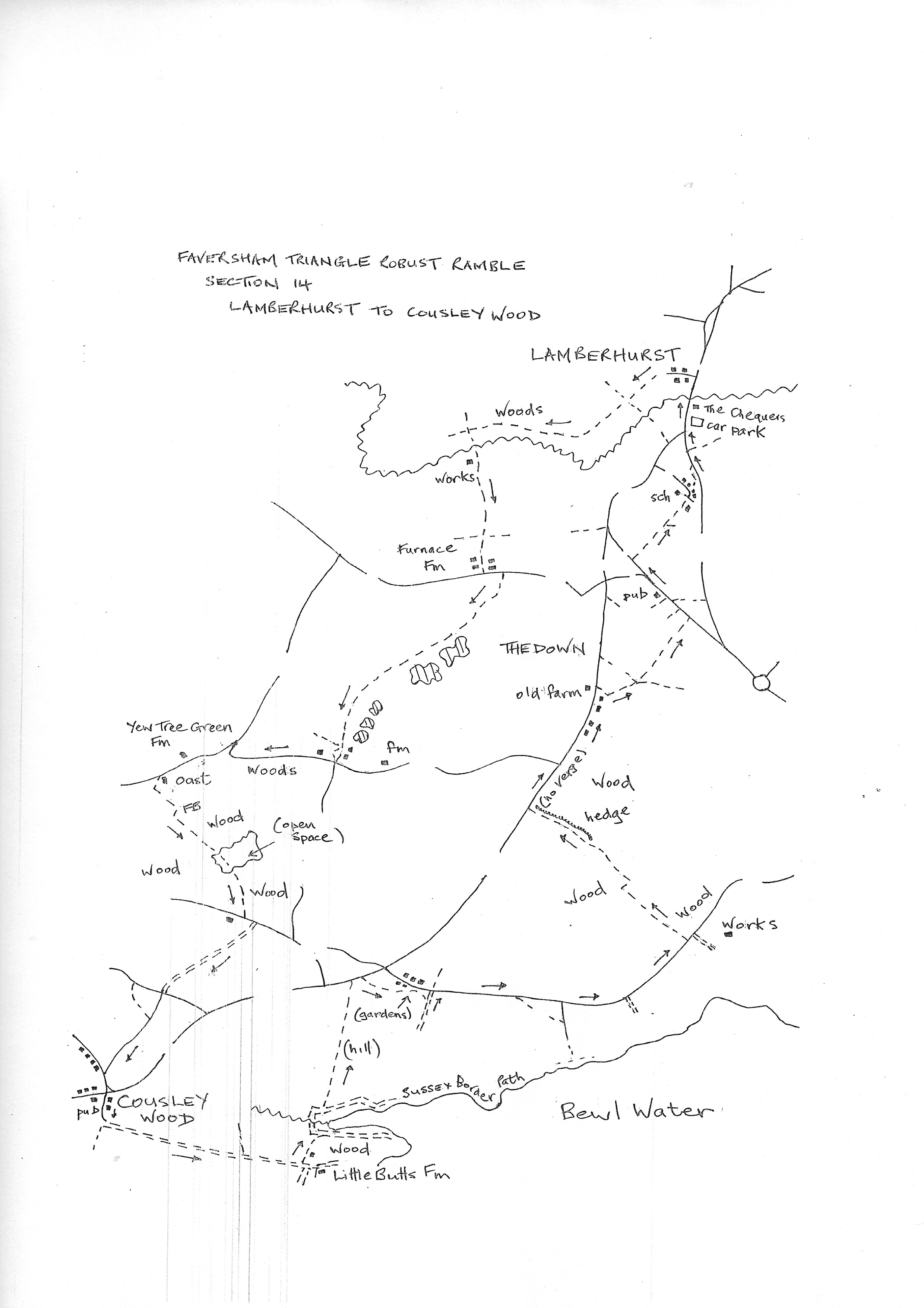
Section 14
Lamberhurst to Cousley Wood
Walk Details
Walk Instructions
Robust Ramble – Kent Triangle - Faversham – Wadhurst – New Romney – Faversham
Section 14 Out
Lamberhurst to Cousley Wood
OS Map: Explorer 136 Royal Tunbridge Wells
Total Circular Distance: 7 miles/4 hours
Start: The Chequers, Lamberhurst. The once public car park behind the pub seems now to be owned by The Chequers, however it is freely open outside trading hours.
Comment: An enjoyable country walk. Undulating countryside with woodland, grassland and excellent distant views. Stiles in various conditions and some steep climbs. Some of the paths seem little used so may be overgrown in Summer. Woodland paths can turn to streams in very wet weather.
With The Chequers behind, turn right up the main road, passing the George & Dragon on your right and Coggins Hall on the left. Turn left down Brewer Street. Keep along here for some way.
Where the road finally turns right, go straight on, passing tall white weatherboarded houses on your right. Reach a metal fieldgate and gap, and continue on a path through trees for ½ mile.
Ignore a path off left opposite old farm buildings, then pass derelict hop pickers huts. Finally reach a junction with an old concrete farm track.
Here turn left and cross a concrete bridge. Pass a pumping station and keep on the asphalt roadway for ¼ mile, always uphill.
Near the top ignore a footpath off left then pass through the buildings of Furnace Farm. Where the drive turns sharp right, go straight ahead on a path through trees to a road.
Ross the road and turn left for 15 metres. The turn right up a drive by Misty Meadow. Soon leave the drive and branch off right onto an enclosed grassy path with a tall conifer hedge on your left, and views across fields on your right.
Where the hedge ends, the path continues downhill, eventually entering woods and dropping down to lakes.
Cross a long footbridge over a stream and continue up through woods at the far side.
Cross an ancient plank bridge and go straight up the other side (ignore what seems a path off sharp left). Soon swing left and pass a pond on your right. Ferns may obscure the path but it goes steeply up to a diminutive stile and on, through woods.
Keep on for some way passing lakes down on the left. Pass through a metal swing gate. After some way reach a second metal swing gate. Cross a grassy farm track to a stile and continue along the top of a bracken covered bank.
Eventually approach a house, possibly Maitlands, and go through a metal swing gate into a very narrow path, passing the house on your left (and dog) and eventually emerging onto a road. Turn right.
Keep along for 200 metres. Near the end the road turns sharply right and goes up to a junction. Turn left here, uphill.
Pass Yew Tree Green Farm on your right and then two oasts on your left. Immediately past these, turn left up steps to a wooden swing gate onto a grassy path. Walk up by a garden to a second swing gate on your right and go through into a field corner.
Turn immediately left down the side of a field to woods at the bottom. Enter the woods and cross a footbridge. Go forward to Y-fork. Keep right on a path going steeply uphill.
Near the top reach another Y-fork. Here bear left and soon enter an open grassy area. Go forward along the top edge.
At the far side re-enter the woods. At a junction bear right and stay on this main path, ignoring paths off left.
Exit at the top onto a road. Turn left for 20 metres, then right, onto a broad track beneath arching trees. Go steadily uphill.
Emerge at a road junction. Go straight across to Windmill Lane. At the end turn left down to a main road and The Vine pub opposite in Cousley Wood. This is the end of the section.
Robust Ramble – Kent Triangle - Faversham – Wadhurst – New Romney – Faversham
Section 14 Return
Cousley Wood to Lamberhurst
OS Map: Explorer 136 Royal Tunbridge Wells
Total Circular Distance: 7 miles/4 hours
Start: The Vine, Cousley Wood; only parking at the pub
Comment: There is some unpleasant road walking on this return as Bewl Water, the dualling of the A21 and main roads focussing on Lamberhurst plus infill housing has fractured the path network. There’s lots of interesting walking to be had on this section, but be prepared a demanding bit of roadwalking to the south of The Down neighbourhood of Lamberhurst.
With the front of The Vine behind you, turn right, down the asphalt slope to the main road. Turn right, away from the main road, on a footpath going along a drive by a house. Stay on this roadway for ½ mile.
In a short distance follow the drive as it swings left, then on generally downhill through trees. After a while ignore a footpath off left, then pass cottages on your left.
Arrive at a turning area in front of Little Butts Farm House. Look on your left for a footpath (this has been diverted out of the farm buildings). Turn down this path with a tall wooden fence on the right.
Where the fence ends, by sheds, turn off left into a field. Immediately turn right, down the field edge to a stile at the bottom. Cross onto a gravel track and turn left.
Follow the gravel track around two righthand bends, looking for a mighty stile on the left into a steeply rising field. Cross this and go slightly diagonally right, up the field to a stile by a wooden fieldgate at the top.
Cross and continue up the pasture to a stile by a metal fieldgate. Then on to the very top corner of the pasture to a stile and a metal kissing gate leading to a drive.
Cross the drive and follow a shaded path through trees and rhododendrons to a road. It is now necessary to turn right along the road for 50 metres (the owner of the woodland has aggressively fenced the edge to preclude a walkable verge).
Turn right into a driveway. Follow it around to the left and soon reach a junction of house entrances. Go straight ahead over a stile by the side of a wooden fieldgate to The Oasts.
Pass the house on your right and join a grassy path down the side of garages. Cross a huge stile and go forward to a smashed one into scrub.
Emerge at a farm track by buildings. Bear right a few paces then left through a gate then over a stile into the foot of gardens. The path then crosses the foot of several gardens without being shielded in any way; there are several stiles so it is easy to follow the route.
The final stile leads onto a wooded farm track. Turn left down to a road. Turn right along it. There is now a long stretch on roadways which give access to Bewl Water leisure facilities.
Walk down the road, ignoring a footpath off right, to reach a junction with Hook Hill Lane. Go straight ahead on the Bewl Water Route for ½ mile, passing entrances to car parks. Eventually meet a public road head on.
Here turn left on a bridleway into woods. At the top of the woods, enter a field through an equestrian gate and bear slightly right across it.
At the far side go through a metal swing gate by a metal fieldgate and cross a stream to a corner of a field.
Bear right along the bottom a short distance then left up the field on a wide but very rough track.
At the top go through a gap in the hedge and continue up the track. Where a hedge appears keep it on your right.
At the top reach a swing gate by a metal field gate and exit onto a busy road. Turn right along it for 200 metres.
Unfortunately, verges are very meagre and the traffic, though patchy, very prone to excessive speed. Pass a wood on the right (sadly no apparent access). Arrive at houses and safer walking. Keep forward looking for a narrow enclosed path off right, opposite an old farm and industrial units.
Follow this leafy path around the rear of houses. Ignore a path in from the left, and soon another curling off right. Keep straight ahead still along the back of gardens, on a wide path with arching vegetation.
Emerge onto a busy main road, cross to a pavement (!) and turn left up it. Pass a pub but then another short distance without pavement or verge, this is a very DANGEROUS short section.
The road divides. Keep straight ahead on the quieter road passing a bus stop on the left.
After the last house on your right, go right down the drive to Tutty’s. Go through a wooden swing gate onto a concrete track. Where this ends bear slightly right to continue down on a tarmac path bordering a pasture.
Meet houses then pass a school on the left. Join the road a few paces looking for a vehicle access way between houses on your right (there is a parking restriction sign). Go down here and continue on a footpath at the end out to a road.
Turn left on the road down to a junction, then right to quickly reach The Chequers and the start of the section.