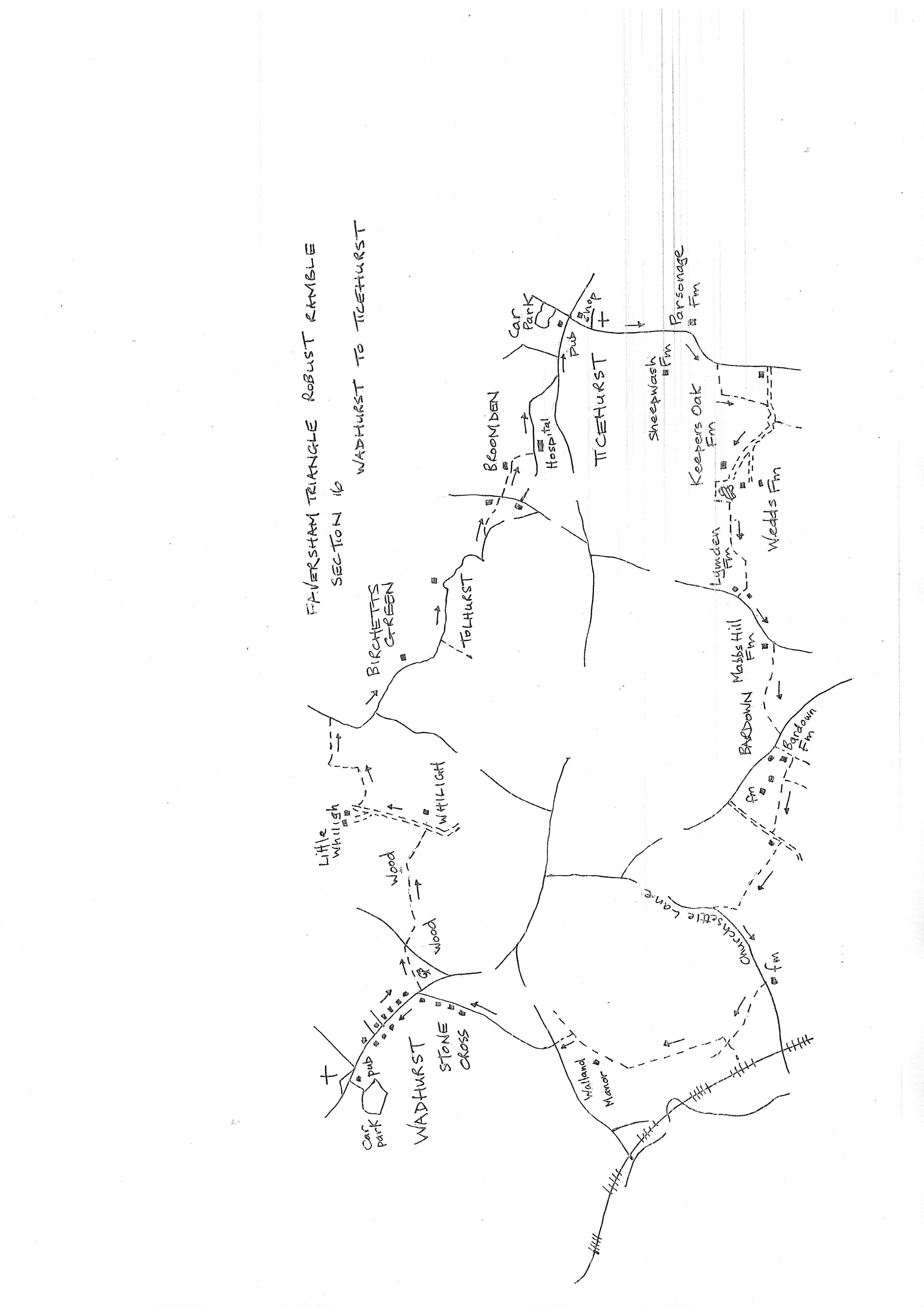
Section 16
Wadhurst to Ticehurst
Walk Details
Walk Instructions
Robust Ramble – Kent Triangle - Faversham – Wadhurst – New Romney – Faversham
Section 16 Out
Wadhurst to Ticehurst
OS Map: Explorer 136 Royal Tunbridge Wells
Total Circular Distance: 10 miles/6 hours
Start: The Greyhound, Wadhurst. There is a public car park accessed down the side of the Greyhound in the centre of Wadhurst,
Comment: This is a fairly short section of about 3.5 miles, however the return is much longer and plenty of time should be allowed for the circular walk. There is a good deal of uphill walking and many stiles. Due to the effect of creating Bewl Water, the local footpath network is considerably compromised. Half of this walk is on country roads but they have very little traffic and are pleasant walking.
With the Grehound pub behind, turn right, back down the main road out of Wadhurst. Eventually reach Brinken Lane off on the right. A short distance further on, turn left, off the main road, over a stile onto a path going up through trees.
Reach a hay field and go diagonally right across the centre to the far opposite corner. Exit onto a drive. Cross to the footpath opposite and continue along the field edge with a wood on your right.
Where the wood ends, stay on the field edge as it bears left downhill. At the bottom cross a footbridge into woods (very muddy here). Soon reach a Y-fork, keep left.
Wind round to a metal swing gate and bear left up a rising pasture. Go through an old metal kissing gate at the top, then up steps to a drive.
Turn left for 200 metres. Eventually the drive drops downhill (ignore a stile off right) to reach cottages. Immediately past the first one, The Bothy, on the right, turn right through a wooden fieldgate into a field, and go forwards, downhill.
Bear slightly right across an open section, then reach and pass trees down on your left. At a Y-fork turn left, steeply downhill, to go alongside the trees (very muddy) and reach a bridge at the bottom.
Cross the bridge. Ahead are three paths going uphill. The route seems to be up the middle which looks like the bed of a stream. Take the path on the right up to a field corner and go up the edge of a field with trees on your left.
At the top of the field the three paths merge. Turn right on a sunken path up the side of a field. At the top emerge onto a country road. Turn right for a mile.
At a road junction turn left to Birchetts Green. Pass the farm house, then drop down to a bridge then uphill again (ignore a footpath off right).
Pass by the scattered houses of the hamlet of Tolhurst. Finally, on a righthand bend, just after a heavy fieldgate into a field on your left, look for a narrow footpath off left through a gap in a thick hedge (unusually there is no waymark).
Through the hedge enter an area of scrub. Turn immediately right up to a footbridge and stile into a pasture. Go straight up the pasture with houses ahead to a stile at the top into a narrow, enclosed path which soon reaches a road.
Turn right a few paces, then left over a stile into a field. Go ahead along the edge. At the next corner cross a stile into an enclosed path between gardens. Pass a house and continue down a grassy way in trees.
At the bottom go through an old wooden fieldgate and continue on a rough path through bushes. Ignore a path off left and continue forward to a stile. Enter a steeply rising pasture.
In the top corner emerge onto a road. Turn left along this for ¼ mile, passing a private hospital, to reach a main road. Turn left for ¼ mile into Ticehurst. At the central square reach The Bell pub with the former Hotel opposite, and the end of the section.
Robust Ramble – Kent Triangle - Faversham – Wadhurst – New Romney – Faversham
Section 16 Return
Ticehurst to Wadhurst
OS Map: Explorer 136 Royal Tunbridge Wells
Total Circular Distance: 10 miles/6 hours
Start: The Bell, Ticehurst. Just past The Bell, on your left, is a side road leading to a public car park.
Comment: Ticehurst has a pub and several cafes and shops. The return walk is twice as long as the outward one so allow plenty of time. The country is undulating with many hills, also good views. There are many stiles. A small amount of road walking on country lanes. A visit to Ticehurst church is recommended.
From The Bell pub cross the main road to Church Street opposite. Go down this street passing the Hotel building and the Post Office on your left, then the parish church also on the left.
Keep along for ½ mile mostly on a pavement and path. Pass Sheepwash Farm on the right and Parsonage Farm on your left.
Then look for a footpath off right. Go down through trees (ignore a stile on left) and through a metal fieldgate into an area of scrub.
Cross a footbridge in the bottom corner and go forward up a marshy area. Climb a bank into a large meadow. Go forward, straight across it ( there is a cottage down on the left).
Emerge onto a tarmac farm drive. Ignore the footpath going left, instead go forward, up the drive for ¼ mile. Pass a footpath off left into trees and keep on to the very end of the drive at Keepers Oak Farm.
Pass through farm buildings. At the very end join a grassy path going up between wooden garages and past a tennis court. Continue around the top to a wooden kissing gate.
Through this wind up through tees, passing a pond on your left. At the top go through a wooden kissing gate into the corner of a field. Turn left along the bottom edge of the field.
Cross a stile by a metal fieldgate, ignoring a vague waymark sign, turn sharp right, along the top edge of a field with a wire fence on your right. At the far side cross a stile by a metal fieldgate and continue on a farm track with woods on your left.
At the end of the trees on your left, bear diagonally left down and across a narrow field to a stile by a metal fieldgate facing towards a distant oast. (Do not be tempted towards a farm bridge sharply left at the bottom of the field).
Cross the stile and go forward along the bottom edge of the field. At a corner, where the edge begins to rise, drop down left to a stile by a wooden fieldgate and on through bushes by a stream on the left, to emerge on a concreted area. Bear right, past a farm house to a road.
Turn left on this road for 150 metres, uphill. Just past Mabbs Hill Farm, turn right on a grassy, but muddy, bridle path and continue uphill.
Finally emerge onto a road. Turn right for 50 metres then left over a stile set in a brick wall by a vehicle gateway.
Go down through farm buildings. At the far side, turn leading into a field. Follow this track, now an earthen path, across the top of the field to trees at the far side.
On reaching the treeline DO NOT STAY ON THE TRACK DOWN THE EDGE OF THE FIELD. Find a way up the bank and turn left on a feint path along close to the treeline.
This soon reaches a broken stile and swings into the trees. Scramble across a rough area of roots and fallen trees to another broken stile and sheep hurdles at the corner of a large pasture.
Bear right across the top of the pasture, fairly close to the hedge on your right. Go through a metal fieldgate ahead and continue past a dump of old vehicles on your right, into and across a further pasture, to a mighty wooden kissing gate in the far corner.
Turn left on a gravel track a few paces. Immediately past a cottage on your right, turn right on a grassy path with a hedge on your right.
At the corner ahead, go through a gap into the foot of a rising Deer Park. Go diagonally up and across the centre to the top opposite corner. Exit through a wooden kissing gate onto a road. Turn left for 200 metres.
Opposite Churchsettle Farm turn right over a sleeper stile and through an iron gate into a shady path leading to a rough meadow. Continue down to a rugged stile in the bottom corner.
Cross and bear right down the field edge. Reach a corner and wooden fieldgate. Go through then diagonally left down and across the middle of a sloping hay meadow, to the lowest, opposite bottom corner.
Go through a wooden fieldgate and on along the fence on your right. Soon cross a long footbridge. Bear right up the hedge on your right to the top corner. Ignore a stile just left of the corner. Instead bear right through a gateway in the corner.
Continue up a rough track, passing fenced trees on your left. At the top of the hill cross a stile and continue up the meadow edge with a hedge on your left.
At the top corner go straight through a gap and keep on, bearing right, across the pasture, to the right of farm buildings ahead. Reach a swing gate by a wooden fieldgate into trees. Some good views here.
Go through a further wooden gate and down the edge of a pasture (some boggy patches). At a corner turn left through a wooden gate by a wooden fieldgate and go up a grassy way with the hedge on your left and fence on the right (ignore a path which goes on across the pasture).
Exit at a road junction. Cross to go up Brinkers Lane. Keep up here for ¼ mile. At the top by Stone Cross Farm, turn left on the main road and walk up into Wadhurst.
In the village centre find The Greyhound pub on the left and the start of the section.