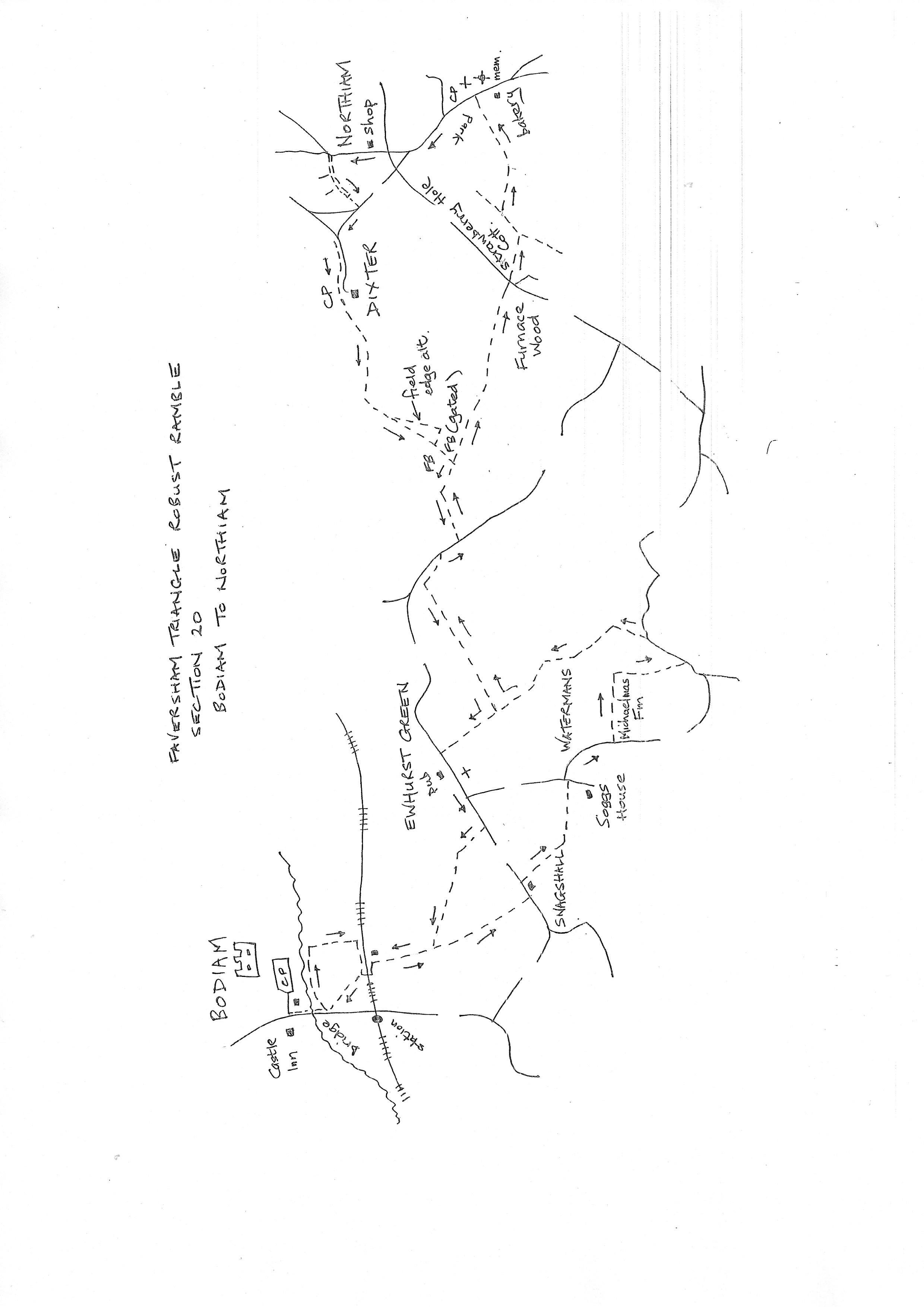
Section 20
Bodiam to Northiam
Walk Details
Walk Instructions
Robust Ramble – Kent Triangle - Faversham – Wadhurst – New Romney – Faversham
Section 20 Out
Bodiam to Northiam
OS Map: Explorer 136 Royal Tunbridge Wells & 125 Romney Marsh
Total Circular Distance: 8 miles/4 hours
Start: The Castle Inn in Bodiam
Comment: As the route is entering the marshland environment with the River Rother a significant element, there are limits to the paths running east to west. The Sussex Border Path links the major direct paths, so this section makes use of it with diversions around the neighbouring tracks. There is plenty of variety with fieldedge, woodland and leafy enclosed paths, as well as short steep climbs in undulating countryside with occasional eyecatching views.
With The Castle Inn behind, cross the road to the car park entrance opposite. Immediately past the gates turn right through a wicket gate behind the toilet block and walk up, parallel to the road on your right, to a further small wooden gate. Exit and go forward over the bridge across the River Rother.
Reach a gate on the left into a marshy field. Enter and bear left up onto the river bank. Go forward, away from the road, on the bank. Reach a metal fieldgate across the bank. Here turn right, down the bank and up the side of the field with a fence and ditch on the left. Reach a line of trees and a railway at the top of the field. At a corner turn right and go along by the railway to a stile and crossing on the left.
Cross the line and bear left up to a barn. Then go up the right side of this barn to a footbridge. Cross and keep on uphill.
At the top corner of the pasture, cross another footbridge and keep forward to a junction of paths by a swing gate in a fence.
Do not go through the gate but bear right up a bank and go forward past an area of scrub. Once past this drop down to the fence on your left and continue uphill with the fence on your left.
At the top corner, go through a metal fieldgate. Immediately turn right up to a stile. Cross and continue up a farm track to a road.
Turn left past Snagshall Cottage, then immediately right, off the road, up a bank, over a stile, in to a pasture with a pond on your right. Keep forward, downhill.
At the bottom cross a footbridge and keep forward, across a pasture. In the corner, turn left, over a stile, above a pond, into a path enclosed between fences and hedges.
Eventually emerge, over a stile, onto a road. Turn left to a junction, then right along the road. In 120 metres, reach the entrance to Michaelmas Farm on the left.
Look to the left of the main entrance with double wooden fieldgates, to a stile at the side. Follow a fence path uphill and over a broken stile, into woods.
Join a pleasant meandering path well marked through the trees, for some way. Reach and cross a stile in the top corner, and go forward up the side of a field. In the top corner, exit onto a road and turn left.
In 80 metres, where the road turns sharp right, bear left onto a gravel drive, then onto a farm track to Sempstead Cottages.
Just before the cottages, turn left over a stile(broken), and continue down the field edge. In the bottom corner, turn right on a broad track leading to a sloping pasture.
Go on, down to a stile into woods below. Pass through the woods to reach a substantial footbridge. Cross and go on up a field edge with a hedge on your left.
Go through the hedge at the top and immediately turn right on the Sussex Border Path along the field edge.
At the end of a long field, turn right over a footbridge and on down a field edge with a hedge and road on your left.
At the bottom of the slope look for a stile on the left by double metal fieldgates. Cross to a road and turn right along it.
Before a bridge, turn left over a stile in the hedge, into a field. Follow along the bottom edge. At the end, bear right over a footbridge into a large sloping field. Bear diagonally left across it to a footbridge at the far side.
Do not cross the bridge, but turn right along the field edge. In 25 meters, turn left, out of the field, into trees. Soon enter another field and go straight across.
At the far side cross a footbridge and metal kissing gate, and continue along the field edge. Halfway along turn left over the stream then immediately right along the field edge with the stream now on your right.
Emerge onto a road via a metal kissing gate. Cross over to the drive opposite. Immediately turn left, up a bank, into an enclosed path through to concrete pillars.
Reach a field through a metal kissing gate. Go straight up the field, bearing away from the fence on your left, across a corner and on past an old pond, to a gap in the hedge at the far side, Northiam church is dead ahead.
Through the gap turn left uphill (ignore a path signed to the right). In 100 metres, turn off right, across the open field, towards the church again.
At the far side of the field continue with a hedge on your left, to a corner. Cross a long footbridge, and continue up through the trees.
At the top keep along the field edge to a corner. Here join a gravel track going steeply up to emerge on a road in Northiam. Opposite is a car park. Turn right along the road a few paces to a war memorial on a green with seats. The pub has long gone but Will’s Bakery and Deli is opposite.
Robust Ramble – Kent Triangle - Faversham – Wadhurst – New Romney – Faversham
Section 20 Return
Northiam to Bodiam
OS Map: Explorer 136 Royal Tunbridge Wells & 125 Romney Marsh
Total Circular Distance: 8 miles/4 hours
Start: Northiam Green War Memorial; this is close to the parish church and a car park
Comment: Generally easy walking along field edges using some sections of the outward route. Some stiles. The pub in Ewhurst Green is open. Northiam is disappointing for facilities.
From the Green and war memorial, turn back up the main road passing the car park on your right. Keep up the road for ¼ mile passing a recreation ground on the left, then eventually the village shop on your right. Ignore all side roads.
Just beyond the shop, turn right up a residential road called High Meadow. Walk up to the very end, ignoring side roads. Go forward across the turning area to a tarmac path dropping down to a road.
Turn right on the road. At a Y-fork bear left and soon reach another junction. Turn left here but on a footpath concealed between hedges.
On reaching car park area for visitors to Great Dixter house, cross over to a metal kissing gate.
Go down a grassy slope bearing slightly left with a hedge on the left. Keep the hedge on the left all the way along an open field.
Pass a pond and go through a metal kissing gate, then bear right down the field to go through another metal kissing gate at the bottom. Continue straight down the field edge.
In the very bottom corner, turn right with a ditch on your left and go along to a gated footbridge.
Cross this into a field. Bear diagonally right across the field, now on the SBP again. Keep across to trees and exit the field over a footbridge. Immediately turn left along the bottom of the field by a stream.
At the end cross a stile onto a road. Turn right for 30 metres looking for a stile by metal fieldgates in the hedge on the left.
Cross the stile and immediately turn right up the side of the field to a footbridge at the top. Cross and turn left along the bottom of a large field.
At the end go forward over a footbridge in the hedge and immediately turn right uphill with a hedge on your right. Emerge onto a road in Ewhurst Green.
Turn left on the road and walk right through the village passing the White Dog Inn.
Immediately past the last house on your right a sudden vista of Bodiam Castle opens up. Turn right through an old wooden kissing gate and go down the left side of the field. Halfway down the hill bear left to a wooden kissing gate then over to a stile by a wooden fieldgate.
Cross and go forward along the bottom edge of the field to reach a stile by a metal fieldgate and pond. Continue down.
Go through a metal swing gate at the bottom and turn right to a stile and footbridge. Cross and continue down the field edge to another footbridge at the bottom.
Cross and go down the left side of a barn, then left again to a railway crossing.
In the field beyond look diagonally left across to see the bridge over the River Rother in Bodiam. Walk across the field to a gate out onto the road just before the bridge.
Turn right to cross the bridge then through a gate to an enclosed path leading to the entrance to the castle car park.
Turn left to cross the road to The Castle Inn and the start of the section.