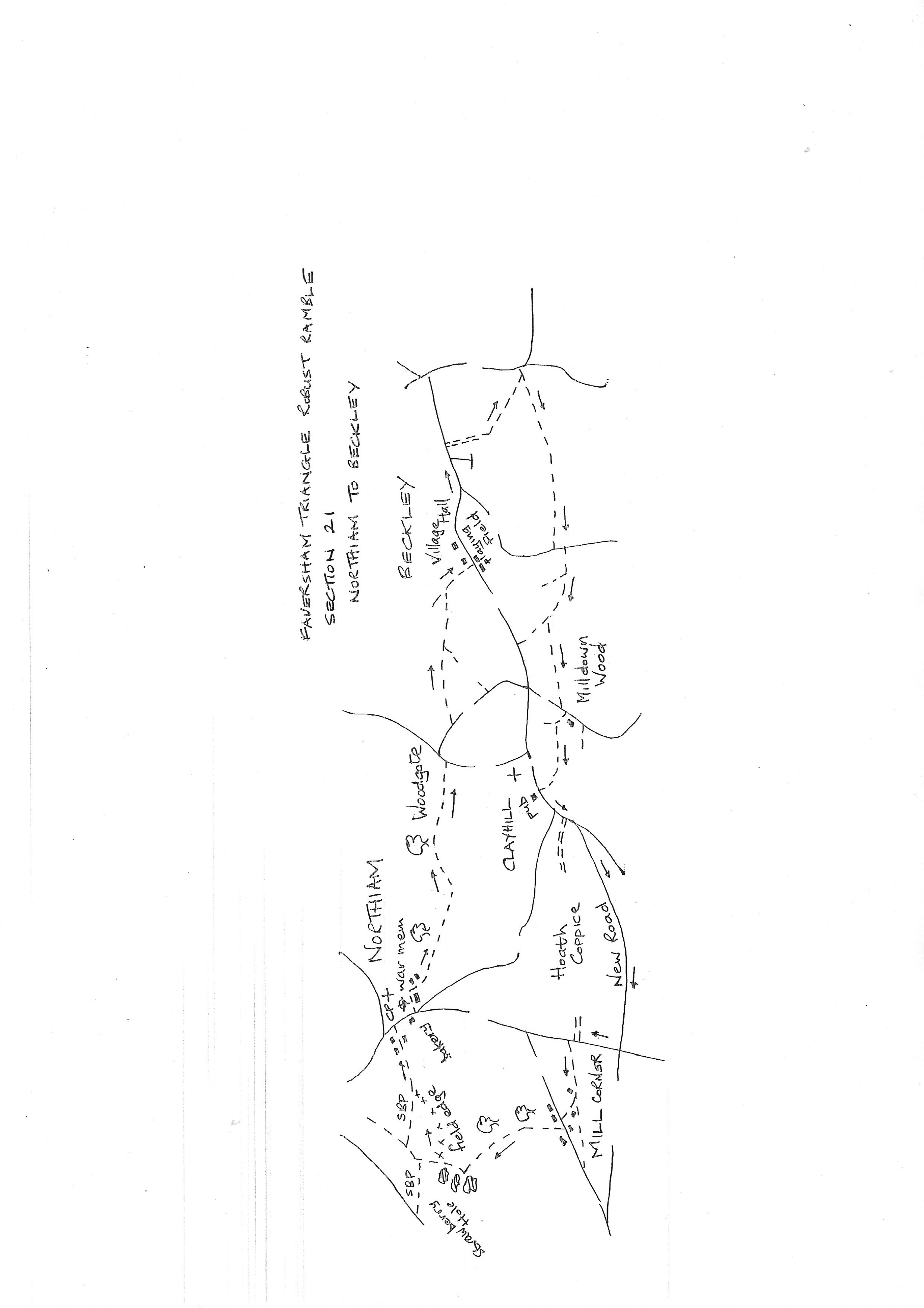
Section 21
Northiam to Beckley
Walk Details
Walk Instructions
Robust Ramble – Kent Triangle - Faversham – Wadhurst – New Romney – Faversham
Section 21 Out
Northiam to Beckley
OS Map: Explorer 136 Royal Tunbridge Wells & 125 Romney Marsh
Total Circular Distance: 7 miles/4 hours
Start: The War Memorial on the Green in Northiam, there is a car park nearby.
Comment: Mostly pleasant walking on the Sussex Border Path. Undulating green countryside mostly along field edges with some woodland. Stiles and footbridges abound so be prepared for some boggy conditions at wetter times. Beckley is a long linear village with no facilities on this section although the end point is at the village hall with a recreation ground opposite and outdoor seating.
With Northiam war memorial on your left, walk down the main road away from the village. In a short distance, at the end of the green, bear left, off the main road, towards Six Bells Mews (sadly this was the village pub). The way is lined by concrete bollards.
Where the bollards end, turn left, up a farm track. Keep along past houses to reach a field entrance. Enter the field and turn immediately left. Stay on the edge of the main field, bearing slightly right downhill.
At the bottom reach a large open field and go straight across. At the far side continue along by a ditch. At a Y-fork by trees, bear left into a further field, passing a pond on your left.
Once again cross an open field to woods at the far side. Wind down through the woods to a footbridge then steeply up the far side to a field and on, across, between fences.
Drop down to cross a footbridge and metal kissing gate into a steeply rising paddock and go up then side to a metal kissing gate at the top. BEWARE this is a very wet and marshy field do not get bogged down.
Continue on a pleasant path by holly bushes to reach a final metal kissing gate out to a road. Turn left down to a junction then right on Rectory Lane.
In 100 metres, just past a large white Regency house, turn left into a driveway. There is a narrow stile to the left of heavy gates. Over the stile continue across a parking area to a second stile and up a grassy rectangle to a third.
Keep forward, gently downhill by a substantial wooden fence on the left. There are boggy sections. At the bottom cross a stile and footbridge and go aheasd to a pond in trees.
Go right around to the far side to a metal fieldgate into the adjoining field. Go through and bear diagonally right across the centre of the field towards tow lone trees at the far side. Exit through a metal fieldgate.
Go ahead towards houses finally emerging onto a main road, through another metal fieldgate, in Beckley. Turn left a short way to the village hall with a recreation ground opposite. This is the end of the section.
Robust Ramble – Kent Triangle - Faversham – Wadhurst – New Romney – Faversham
Section 21 Return
Beckley to Northiam
OS Map: Explorer 136 Royal Tunbridge Wells & 125 Romney Marsh
Total Circular Distance: 7 miles/4 hours
Start: Beckley Village Hall, there is parking here but no shop or pub.
Comment: Undulating countryside with lots of woodland walking. Unfortunately there are many stiles often broken. The pub at Clayhill is open halfway along the return. Unfortunately forestry work in Milldown Wood prevented use of the intended path. Hopefully this is now reinstated but employ careful mapwork here to travel west across the wood. There is a ½ mile walk along a very straight country road out of Clayhill as no parallel footpaths exist and the adjoining wood is private. The final section from Mill Corner is tricky through woods.
With Beckley Village Hall on your left, walk on up the main road for 150 metres. Ignore a side road off right. In 150 metres pass a close called Buddens Green.
Immediately turn right up a farm track between a house and a hedge. At a wooden fieldgate, bear left onto an enclosed path, upto a Y-fork. Turn left into holly bushes.
Keep on up through woods (ignore a path off left) and emerge at the top.
Here turn left (there is a waymark post) on a leafy path through holly bushes. Eventually drop down by a garden hedge to meet a track at the bottom (ignore a metal fieldgate and stile on your left out to a road).
Turn right on the track along the foot of the woods. Keep forward on this obvious path for some way through woods ignoring side turnings. At the top end reach a junction.
Turn right here. Soon pass through a wooden kissing gate and on, up the side of a field with a hedge on the left. Good views here.
Go through a wooden gate and on down a grassy way. Keep on across to a wooden kissing gate then over a paddock to a stile by a metal fieldgate to a road.
Turn left. In 20 metres pass a house then turn right over a stile into a grassy way along a field edge.
Ignore a path off right and continue past sheds to a sloping pasture. Bear slightly right down to a wood.
Cross a stile (broken) and drop down into the wood and cross a footbridge. Continue up for a short distance looking for a path off left. This goes due west across the wood to emerge onto a road. Due to extensive forestry works this path is currently closed. Hopefully on completion the path will be reinstated. If forced to continue north to the main road, please see the route map for way back to the walk.
Having crossed the wood reach a country road. Turn left a few paces then right, into an enclosed path.
Cross a stile and go up to a gap and a junction of paths. Turn left between a wire fence and a hedge on your left. Soon cross a stile (broken) into a field and keep along by the hedge.
Pass through several vineyards. Go down a steep bank to cross a ditch then up on a clear path through the middle of vines. Go through a wicket gate at the top.
Continue across to a stile then on to a gate by a pole in trees. Enter an enclosed path to soon emerge on a main road opposite the Rose and Crown pub at Clayhill.
Turn left past the pub to a junction. Here turn left and in a few paces turn right along New Road. Not an unpleasant road with light traffic but a very long and straight ¾ mile. There is no footpath alternative and the woods on the right are private.
At last reach a crossroads and turn right up the A28; there is a pavement. In 100 metres, just after a house on your left, turn left into Mill Lane.
After 80 metres by cottages bear right, off the lane, on a path in front of the cottages and other picturesque old farm dwellings. Soon reach a road at Mill Corner and turn left.
In 15 metres turn right through wooden gates into a path enclosed between hedges. This is a clear direct path for ½ mile, ignoring side turnings.
Unfortunately, at the top end the path peters out at an area of ponds. Turn right across the top of the ponds to a metal gate with a yellow waymark which can just be glimpsed across on your right.
Go through this gate into a field and then across to a footbridge and steep steps up to a field. The PROW goes straight on here to join the Sussex Border Path but, following local walkers, turn right along the bottom edge all the way round a large field to the very top corner to meet the SBP.
Turn right out of the field on a footbridge. Then up a field edge to join a gravel track in the top corner leading back to the main road in Northiam. The car park is opposite. Turn right a few metres to reach the war memorial and the start of the section.