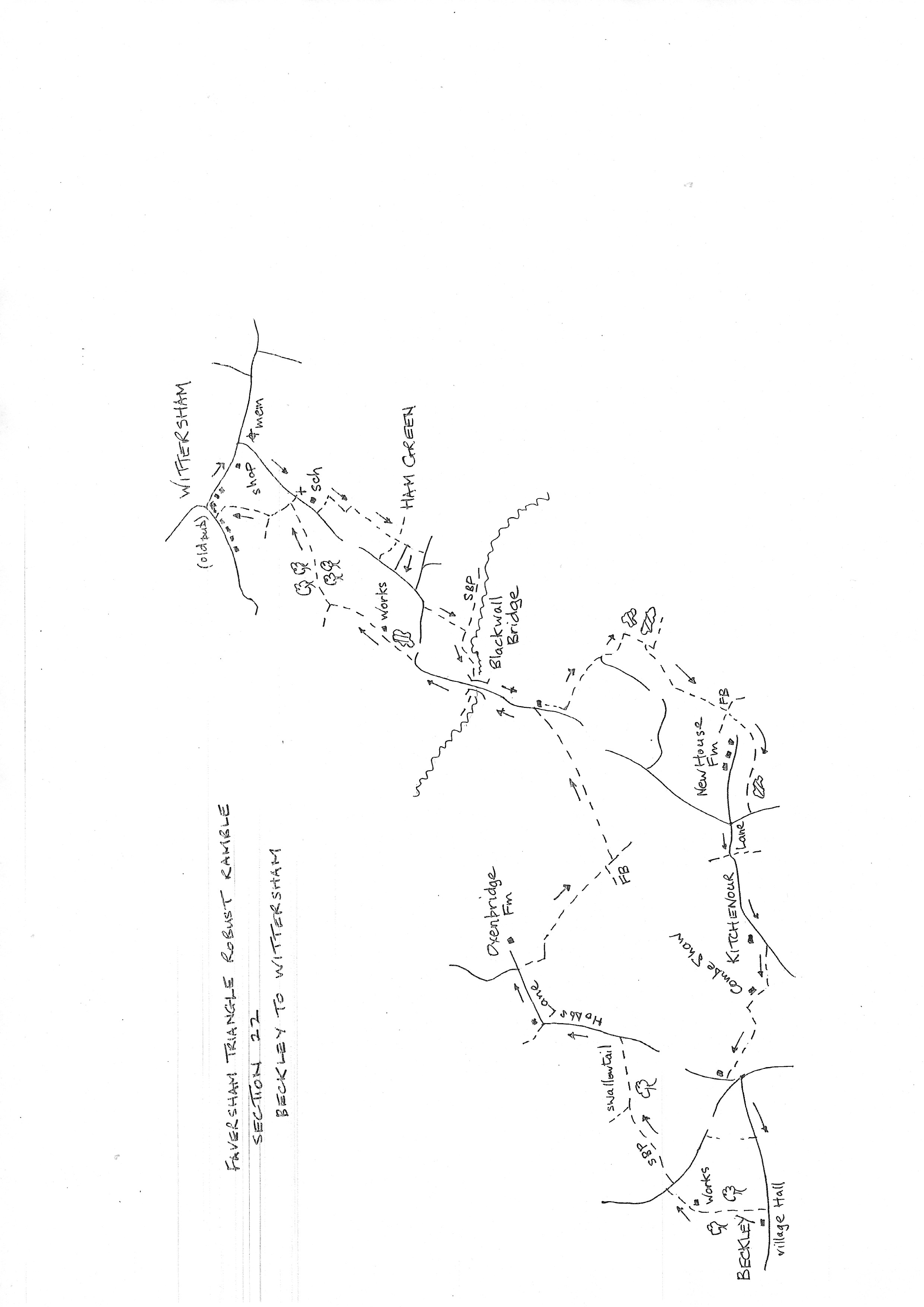
Section 22
Beckley to Wittersham
Walk Details
Walk Instructions
Robust Ramble – Kent Triangle - Faversham – Wadhurst – New Romney – Faversham
Section 22 Out
Beckley to Wittersham
OS Map: Explorer 125 Romney Marsh
Total Circular Distance: 10 miles/5 hours
Start: The Village Hall, Beckley. There is a car park here for those using community facilities.
Comment: Mostly pleasant walking on the Sussex Border Path. Undulating green countryside mostly along field edges with some woodland. Stiles and footbridges abound so be prepared for some boggy conditions at wetter times. Wittersham has lost its pub. There is a village shop also selling coffee, although there is nowhere to sit nearby. The church is very interesting and welcoming. It has exterior toilets and relaxing areas inside. Also exterior bench seats.
Leave the village hall car park and turn left along the road. Immediately past the village hall building, turn left through a metal kissing gate onto the Sussex Border Path. Soon pass through a second metal swing gate and keep forward through trees on a winding green path, for some way.
Cross a footbridge and go up by a water treatment plant. Cross the car park, to the left of the main building, to a metal swing gate behind. Cross a field to a second gate and continue straight across the field to a gate onto a main road.
With great care turn right for a short distance then cross left to a stile into a field. Turn immediately right along the edge to a corner, then turn left still up the field edge, with a fence and hedge on your right.
Near the top of the hill bear right, through a metal gate in the hedge in to an enclosed path with a wooden fence on the right.
Exit at the top into a field and go straight uphill. At the far side of the field, go through a metal gate into a belt of trees, and then on across to a wooden gate.
Ignore a path off left and go forward to a vehicle track and on along it. Finally exit through double wooden gates onto a road. Turn left along this lane, Hobbes Lane for ¼ mile.
Keep on the lane at a right hand bend, ignore track off left by a cottage. Pass Rufford Farm And reach a sharp left bend.
Here leave the road and go straight ahead up a track for a few paces. Turn right over a footbridge and on up a path with a stream on your right.
Cross a substantial footbridge and wind through trees to a further footbridge at the far side. Enter a field and go up the edge with a hedge and ditch on the right.
At the bottom corner cross a footbridge and go forward along the bottom of the next field with a hedge on your left.
Near the end of the field go right, across to a stile, and keep on, uphill, with a fence on the left.
At a footbridge, go left across it then right, up by a fence for 15 metres to a stile. Cross and turn left, on the SBP again, up the field with a fence on your left.
Where the fence swings left, continue straight on to a stile. Cross and continue up to a further stile, just right of farm outbuildings.
Over this reach a field corner. Go forward up the field, veering away from the fence on the right. Aim to the left side of a clump of trees around a pond, on the highest point.
Pass the trees to reach a gap in the field ahead. Drop down towards trees and a house below. Cross a boggy area, then through the trees to exit on to a road.
Turn left for ¼ mile. Cross the river at Blackwall Bridge and keep on up the road. At a sharp right bend leave the road and go forward over a stile. Continue up the field edge with a fence on your right.
Keep on through a metal fieldgate and then onto a stile into a path enclosed between fences (ignore a path off left).
At the top cross a stile and bear right to a further stile into a rising field. Bear left, along parallel with the left edge but not right down on it.
At the far side of the field reach yet another stile and cross into an orchard. Look across the trees to a church tower. The path should cross the orchard diagonally to this tower, but is not evident.
Instead go straight up the lefthand edge of the orchard to the top corner, then turn right, along the top od the orchard, with a substantial hedge on your left. Halfway along, turn left through the hedge and go diagonally across another orchard towards the tower.
At the top go through a rusty kissing gate and turn left on a tarmac path. Join an enclosed path passing a cemetery, and soon reach a wooden kissing gate on your right. Go through into an orchard and follow the diagonal path across it.
At the far side drop down over a stream, then immediately right at a Y-fork, up to a wooden kissing gate into a grassy field. Go forward on the wide main track towards houses (ignore the many wooden gates into gardens).
At the top find a metal kissing gate hidden just behind a projecting fence, and go down an enclosed path to a road. Turn right up to a road junction and the closed pub in Wittersham. Turn right 100 metres to reach the village shop and a coffee stop at the end of the section.
Robust Ramble – Kent Triangle - Faversham – Wadhurst – New Romney – Faversham
Section 22 Return
Wittersham to Beckley
OS Map: Explorer 125 Romney Marsh
Total Circular Distance: 10 miles/5 hours
Start: The Village shop, Wittersham. On road parking only, some places by the church.
Comment: This is becoming more marshland countryside open and isolated with more ponds and watercourses. There is some road walking on country lanes to avoid always using the SBP. Be prepared for some boggy patches. There is a village shop in Wittersham and the church provides exterior toilets and bench seats. Beckley has no facilities. The paths around New House Farm are tricky to find. A stretch of road walking up Kitchenour Lane although this is a quiet lane.
With the village shop behind, turn right along the road, passing a sports field then reaching a crossroads by the war memorial.
Turn right here and walk down for 100 metres to arrive at the Parish Church and tower. Continue past the church and look for a footpath off left just past the Oast House.
Cross a stile into an enclosed path. Emerge into a field and turn immediately right down the edge (very boggy). At the corner turn left and continue to follow the field edge, all the way to the very bottom corner of this large field.
Go through a gap and on down between vineyards on a broad track following telegraph poles.
At the foot, cross a footbridge and pass cottages on the left. Soon turn right on a vehicle drive between hedges.
Emerge onto a road. Turn left for 120 metres. Where the road swings right, turn left past a cottage through a wooden kissing gate by a wooden fieldgate, onto a wide tractor track.
Continue down through wooden kissing gate and stile to go straight across to the river bank. Turn right along it to emerge through gates out onto a road, at the Blackwall Bridge.
Turn left over the bridge and stay on the road for 100 metres. Immediately past a cottage on your left, turn left into the corner, by a power pole.
Immediately turn right and follow the field edge to a corner. Turn left and continue to follow the field edge for a considerable distance.
Where the hedge ends, go on across the open field. Reach and go through a line of trees and go forward along a field edge with a ditch on your left.
At the bottom corner of the field, just before ponds, turn right along the bottom edge of the field. Just after the last pond, ignore a path off left and continue straight across the field ahead.
At the far side find and cross a stile by a large tree, into a sloping field. Bear diagonally left, down towards power lines.
At the bottom bear right with the hedge on your left, looking for a metal fieldgate on the left. Go through this and forward across the bottom (wet) edge of a pasture (a farm is over on your right).
Reach, but ignore, a footbridge on your left, and keep going with a hedge and ditch on your left. Go through a metal fieldgate and continue along by the ditch all the way to a road.
Turn right up the road a short distance then turn left on Kitchenour Lane for ½ mile. Ignore the SBP off right and go on for some way. Immediately past the buildings of Kitchenour, cross a high stile on the right into a field corner.
Cross diagonally left along a line of poles. At the far side of the field, exit through a gap and turn right up the field edge.
At the end of the field cross a sunken drive through a wooden swing gate then a stile into a sloping field. Bear diagonally left down to the end of a treeline.
Cross a footbridge then metal swing gate, and bear slightly diagonally left up across the field towards an oast house.
Cross a stile at the top onto an enclosed path and drop down to a road.
Turn left a few paces to a T-junction, then left a few paces more to a round-a-bout. Turn right on the B2088 into Beckley and in ¼ mile reach the village hall and start of the section.