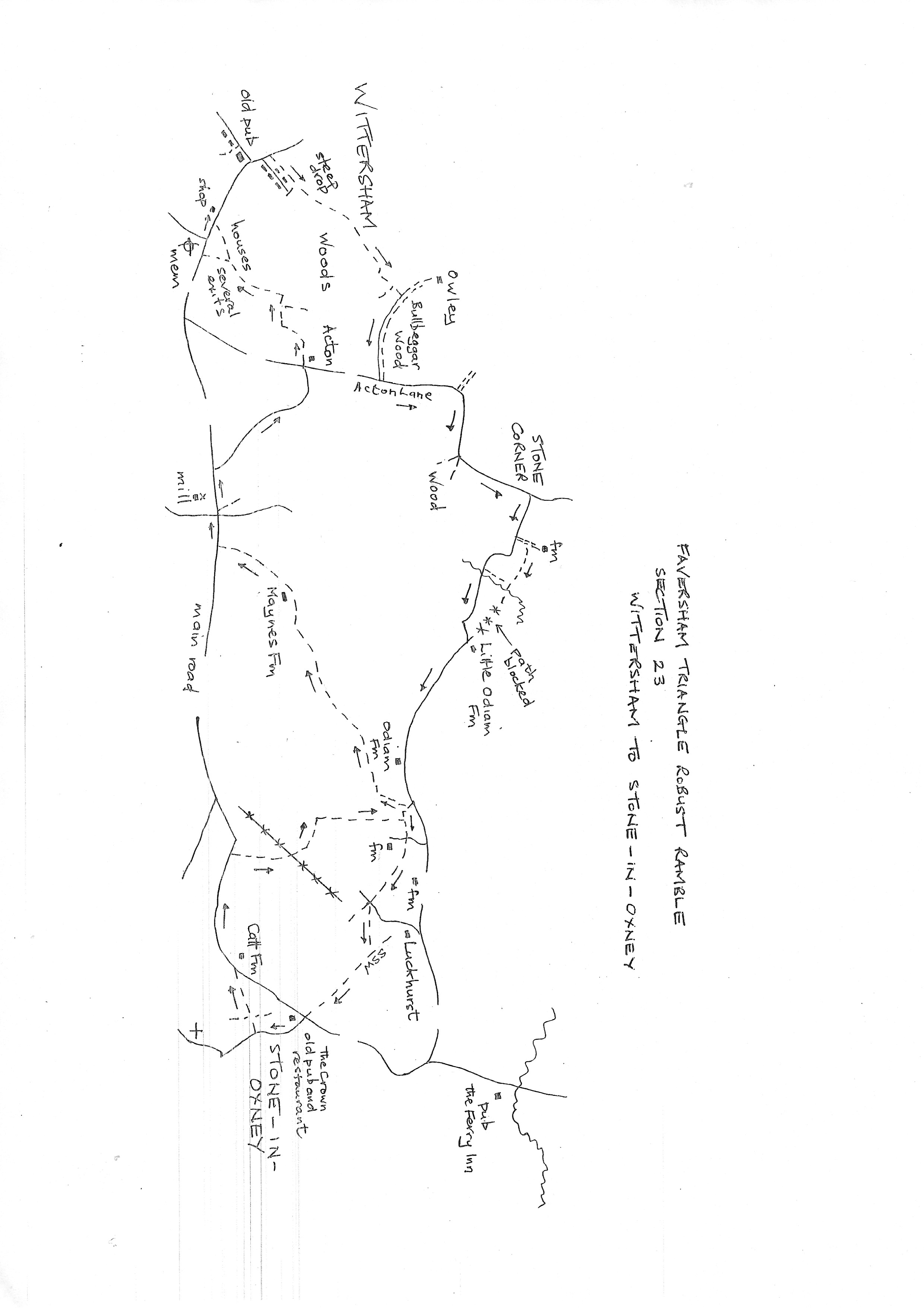
Section 23
Wittersham to Stone in Oxney
Walk Details
Walk Instructions
Robust Ramble – Kent Triangle - Faversham – Wadhurst – New Romney – Faversham
Section 23 Out
Wittersham to Stone in Oxney
OS Map: Explorer 125 Romney Marsh
Total Circular Distance: 8 miles/5 hours
Start: The Village shop, Wittersham. There seems no car park in Wittersham so on road is necessary. There are two residential closes near the start. Please note there are no facilities in Stone-in-Oxney. The pub is a restaurant open Thursday to Sunday including lunchtimes and would probably provide a snack. The only place to sit is by the bus stop at the end of the section.
Comment: As the route crosses the Isle of Oxney there is more marshland countryside, open and isolated with more ponds and watercourses. There are fewer footpaths and they don’t link so easily. Hence there is road walking on country lanes although the traffic is sparse. Be prepared for some boggy patches, but also be warned that in Church Wood on the first path there is a very challenging steep drop of steps which are covered in mud and water drains down them. Walking poles and stout boots are absolutely crucial. This is hostile territory for walkers with neglected paths and efforts to deter walking. The countryside views are splendid and KCC waymarking and stiles have kept the path network in existence. There are many stiles in various stages of condition. Do not take this section on lightly.
With Wittersham village shop behind, turn left along the road. Stay on the main road, to zig-zag around the old pub building at the junction. Stay on the main road to pass Lloyd Green on your right. Almost immediately turn right up a footpath between houses, a wide muddy drive.
Pass new brick gateposts and continue on an enclosed path between fences, down through woodlands. Reach a VERY CHALLENGING set of steps down into a deep ravine. Very narrow, with each riser very tall, possible better in dry weather but lethal in wet weather with the steps obscured by mud and water cascading down the whole flight. Take great care,
At the bottom cross a plank bridge and climb steeply up steps the other side which are less demanding.
At the top, bear left across to a wire fence alongside a pasture. Go up the path here close to the fence on your left.
At the top pass through two massive gates. This is sheep country. Go forward on a sheep trail which might be very muddy. Pass a stile on the right and go on a little further to see a stile straight ahead between two metal fieldgates.
Cross this stile into an enclosed path between hedges and follow it up to emerge onto a drive (ignore metal kissing gate off right).
Turn right on the drive and reach a T-junction with a country road. Here turn left on Acton Lane for ¾ mile. It is possible to follow the adjoining field edge but this is not a PROW. Eventually reach Stone Corner road junction. Turn right here. In 100 metres turn left into the drive to Stone Corner Farm House and Oast.
Go forward as far as possible, which is not very far. Then look for an unmarked wooden swing gate on the right. Go through in to a garden. Go forward close to the bushes on the left to find a way through to a path going forward with a wooden fence on the left and a tall hedge on the right.
Pass through two wooden fieldgates to reach an orchard. The path should go straight across and it may be possible if the fruit trees are pruned and not in full foliage. Otherwise find your way around the edge to the end point.
At the far side go through a gap between to tall trees and go straight down an open field. The path should go over the stream at the bottom and on, up the field ahead. There is no trace of this. So, reluctantly, turn right along the stream to emerge onto a road. Turn left up the road for over ½ mile.
Pass farms and oasts and finally Odiam Farm. Keep on for a good way still, to just past a pond, find a stile on the right. Cross into a waterlogged field and go straight up the edge for a short distance.
Shortly, go left over a stile into a window frame storeyard. Cross over and continue up a green way between a caravan and a horse sand school. Exit through two wooden gates in to a pasture (ignore path off right).
Go straight across. At the far side, exit through a wooden swing gate and footbridge onto a drive.
Cross to a stile by a gate and continue past a pond into the top corner. Here cross a VILE stile and meet a grassy track. Bear left. Keep by the fence on your right, up towards a pylon.
Reach a stile. Disregard the waymark which indicates left, and go straight across the field ahead, past the pylon and pond on the right, bear slightly right to the right end of the woods coming in from the left.
Hidden at the back of the corner of the fence is a stile into the end of the wood. Cross and go down, then right, upto a field.
Here the path divides. Go diagonally left across the open field well right of the line of poles, to the top, opposite corner of the field.
Exit onto a green way and go forward, past well pollarded trees, with the Saxon Shore Way having come in on the left. Go up, to enter a rising pasture, with the houses of Stone-in-Oxney ahead.
At the top emerge by a bus stop at a road junction with The Crown pub now a restaurant, opposite. The Crown is open Thursday to Sunday. Sadly, this is the end of the section. There is a seat here.
Robust Ramble – Kent Triangle - Faversham – Wadhurst – New Romney – Faversham
Section 23 Return
Stone in Oxney to Wittersham
OS Map: Explorer 125 Romney Marsh
Total Circular Distance: 8 miles/5 hours
Start: The Crown, Stone in Oxney. There seems no car park in Stone, so on road is necessary. Please note there are no facilities in Stone in Oxney. The pub is a restaurant open Thursday to Sunday including lunchtimes and would probably provide a snack. The only place to sit is by the bus stop at the end of the section. There is a recreation ground just north of the start and the Memorial Hall – passed at the start of the return – sometimes offers facilities.
Comment: As the route crosses the Isle of Oxney there is more marshland countryside, open and isolated with more ponds and watercourses. To make a circular walk linking road walking is needed. Several of the paths are little used and some of the many stiles are in poor condition.
From the bus stop, cross to the road opposite and go down the side of The Crown. Keep up the road for 80 metres. On nearing the end of the housing, turn right up a drive by a telegraph pole, there is a waymark. The drive soon becomes a wide grassy way going steeply up.
Go through a wooden swing gate by a metal fieldgate. Continue straight up the hill (notice the church dramatically over left). Soon ignore a cross path.
At the top go through a wooden swing gate and on, up the side of a pasture to a metal kissing gate.
Bear slightly diagonally left across the next pasture to the farthest opposite corner, well left of the oast.
Exit through a metal kissing gate and drop down to a road. Turn left for ¼ mile.
Just before a sharp left bend, turn right off the road through a gap in the hedge and go straight down the pasture.
Drop down into a woodland and cross to a footbridge, then up to a stile into a field. Go diagonally right across the field, midway between two pylons.
At the far side cross a footbridge and stile and go forward, tight against the fence on your left, to a stile at the end.
Go diagonally left down the next field to a metal swing gate, close to the bottom corner. Through this descend steps to a footbridge then up.
Bear diagonally right across a stand of trees to a stile by a wooden fieldgate. Cross the next pasture diagonally left to the opposite corner and find a stile into a thicket.
Bear right across to another stile (broken). Cross and keep left, down the field edge towards a shed. Before reaching it turn left through two wooden swing gates, ignore the single gate closer to the shed.
Go along a grassy track then over a storage yard, to a stile behind rubbish, into a field. Turn right down to wooden gates and a stile.
Do not cross, but turn around to take a second path from this point. Go diagonally right across to a fence and follow it up the side of the field.
At a corner, follow the fence to the right a short distance to the next corner. Go through the fence here at a broken gate into the next field, and cross diagonally left to a stile some distance up the opposite fence.
Go diagonally left up a steeply rising field, heading for the highest point. Reach a stile and gateway at the top. Go through and continue up the edge of a large field with a fence and hedge on your right. Count the hedgerows in the fields on your right as you go.
At the end of the second hedgerow find a stile and footbridge tucked in a corner. Cross and turn left up the field edge, continuing in the same direction but with a hedge now on your left.
At the top of the field cross a stile and bear right across the corner of the field ahead, to the rear of the farm.
Cross a broken stile, then on across a paddock to a metal fieldgate, and almost immediately a broken stile beyond.
Now bear left along the fence jup the side of the farm. At the top cross two stiles into a boggy pasture and cross to two more stiles into a further pasture. Bear right to the top corner and exit on to a main road.
Turn right and walk along 150 metres looking out for the second side road turning off right.
On reaching this turn up it for ¼ mile. Eventually at a T-junction in Acton, cross straight over to a footpath at the side of a house.
Go straight up along the edge of a parking area to join an overgrown path between buildings. Cross a stile at the top and b ear left, up and around a large pond on your left.
Follow the field edge down and around, then along the lower edge to reach a substantial concrete farm bridge. Cross and turn right along the bottom of the field.
In 100 metres turn left up the field to the end house at the top. Here bear diagonally right out of the field into housing development. Turn left down a grassy strip to find a way to the main road ahead.
All roads in the estate are dead ends and feed out onto the main road so just keep going.
On reaching the main road in Wittersham, turn right to soon return to the village shop and the start of the section.