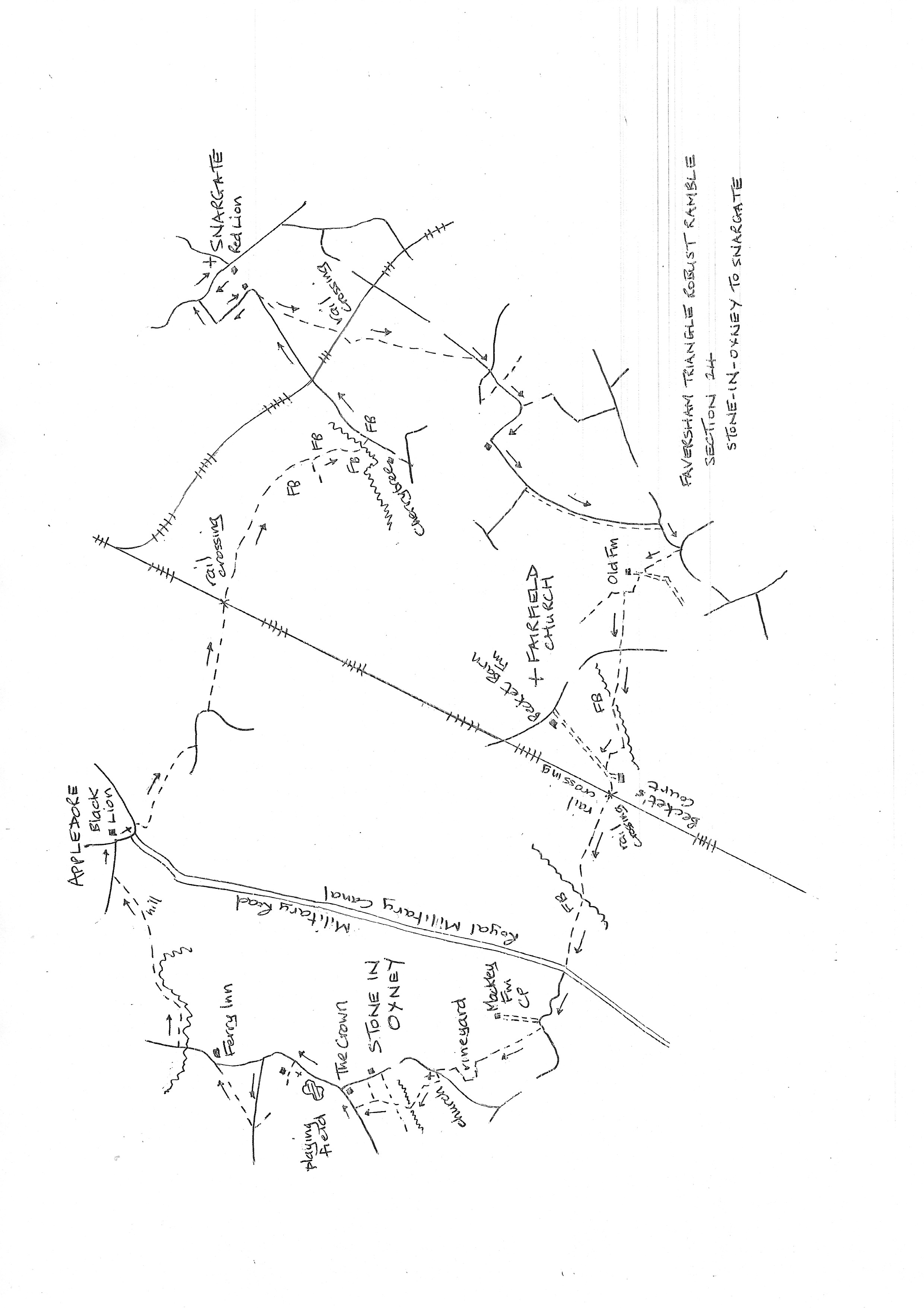
Section 24
Stone in Oxney to Snargate
Walk Details
Walk Instructions
Robust Ramble – Kent Triangle - Faversham – Wadhurst – New Romney – Faversham
Section 24 Out
Stone in Oxney to Snargate
OS Map: Explorer 125 Romney Marsh
Total Circular Distance: 9 miles/6 hours
Start: The Crown restaurant in Stone. There is limited on street parking nearby.
Comment: Quite a tough walk as some paths had disappeared and there were difficulties in finding paths across huge fields of crops where there was no reinstatement. There is no shelter when crossing these fields so careful preparation should be made form both sun and rain. The pub at Snargate does not open on Mondays and appears not to do food. The pub at Appledore does both of these.
With The Crown behind, go straight up the road to Appledore. Pass a playing field on your left. Soon reach a quaint white weatherboarded Baptist Chapel on the left. A footpath should turn off here but no evidence of one exists.
Continue up the road. Turn left down the next side road to Ebony. Pass an old house on the left. Some way beyond turn right through a gap by a metal fieldgate into the corner of a large field.
Head diagonally left across the centre of the field towards the left end of the biggest buildings at the far side.
Exit through a hidden gap in the fence at the topmost corner, into the car park of the Ferry Inn. Walk across to the road and turn left to cross a bridge over the Reading Sewer.
Immediately reach a metal Kissing gate on the right and pass through to the bottom corner of a field. Bear diagonally left across the bottom section of the field to meet the sewer again at the far side.
Go forward on the path with the sewer on your right. Where the Reading Sewer swings away to the right, bear diagonally left across a large flat field. Aim for an obvious hill ahead.
At the far side cross a footbridge to the foot of the hill and immediately go forwards and upwards.
Cross the hill to he far side and a difficult stile exiting onto a road. Turn right on the road and soon reach a T-junction in Appledore with the Black Lion pub opposite.
Turn right down the main road, to cross the bridge over the Royal Military Canal. Immediately turn right, then left, down to old white fieldgates into a field.
Go forward along the edge of the field. Towards the far end, veer right across to a footbridge in the hedge leading out to a road. Turn left on the road for 100 metres.
Turn left off the road, over a footbridge and continue straight across the field to a further footbridge (this on the site of a WW2 concrete bridge part of the PLUTO fuel supply pipeline to France in 1944).
Over the bridge bear slightly left around the field edge then on up the edge for some way, to a railway crossing. Over this continue straight ahead for a good distance.
Eventually follow the field edge around to the right to a footbridge. Cross and continue across the field to a tractor bridge by bushes.
Continue forward. Halfway across bear right, then left as the path heads just left of a red roofed house. Cross a final footbridge, then a short distance more to exit onto a road.
Turn left for one mile on this very quiet road, crossing the rail line to Dungeness halfway. Unfortunately the road jigs left then right at the end before reaching the main road. Turn right on this to reach the pub in Snargate and the end of the section (the footpath cutting off this last corner no longer exists).
Robust Ramble – Kent Triangle - Faversham – Wadhurst – New Romney – Faversham
Section 24 Return
Snargate to Stone in Oxney
OS Map: Explorer 125 Romney Marsh
Total Circular Distance: 9 miles/6 hours
Start: The pub in Snargate. Parking at the pub if a patron.
Comment: A long return with some difficult walking so allow plenty of time. The paths around Fairfield are difficult to find.
With the pub behind, turn left, back down the outward route, down the first side turning on the left. The road soon turns left, then right at a white cottage.
20 metres further on, where trees begin on the left, turn left on a path going diagonally right across the field towards distant wind turbines.
At the far side cross a footbridge and continue across the next field in the same direction.
At the far side go forward with care over a rough patch to a metal fieldgate. Through this turn sharp right along the field edge to a railway crossing.
Over this go forward through an old gate and up by the hedge on your right. Follow this as it soon bears left.
Where the hedge ends go forward a few paces to a field corner. The footpath continues here going diagonally right across the huge field towards distant wind turbines.
At the far side cross a footbridge. Here turn significantly left (the direction of the footbridge is misleading as it leaves you pointing west when the path is going south) and cross the corner of the field, heading towards distant King’s Farm (Cliftonville Farm is closer but too much left).
A long wooden fence marks the exit onto a road. Turn right on this narrow, secluded lane for ½ mile.
Go straight over crossroads and at the next, T-junction, turn right for ¼ mile. Pass cottages on a bend and at the next right turn, go left off the road into Saddler’s Wall Lane.
A very strange byway, sometimes wide and clear, then narrow and overgrown, particularly at the far end.
Exit onto a road and turn right to reach a road junction. Here turn sharp right on a footpath across the centre of a huge field towards Old Farm.
Reach and cross a concrete farm drive. Go straight ahead over a rough area to a gated footbridge.
Over this two paths should diverge. The left one (to be used on this route) is missing. Turn right up the edge of the pasture to a metal fieldgate and sheep pens.
Through the gate turn left along the fence, then over the pasture to a metal fieldgate. Through this continue up the next pasture to double rusty fieldgates at the far side. Exit onto a road.
Turn right a few paces, then left, through a metal kissing gate to a path across a field.
Pass through a hedge at the far side and continue to a long footbridge at the far side.
From the footbridge the path should bear left diagonally across the field to meet a farm drive at the entrance gate to a large house on the left called Becket’s Court. The alternative is to turn left along the field edge and follow it all the way round to the entrance gate.
Turn left through the entrance, then through another metal fieldgate to the right of the house, into a pasture.
Go down the pasture and through another metal fieldgate at the bottom. Now turn right up to a stile and railway crossing.
Over this go straight across a huge field to the Five Watering Sewer, then on, diagonally left across another huge field to cross the Royal Military Canal and reach a road.
Cross the road to a small sideroad opposite and wind uphill for ¼ mile. Pass the entrance to Mackley Farm and immediately turn right across a stile by an old wooden fieldgate. Bear left up the field.
Cross another stile at the top and go forward across a narrow paddock to a metal kissing gate at the far end.
Continue down the next field, with a hedge on your left, through a metal kissing gate by a metal fieldgate, and on, steeply downhill, in the same direction.
In the very bottom left corner is a metal kissing gate. Through it, bear left, uphill by vines. Keep all the way around the edge of the vineyard to the far side (original path diverted).
Go through a gate into a sheep pasture with Stone in Oxney church ahead. Keep across the top of the pasture to a gate onto a road below the church.
Cross the road and climb the slope to the church entrance. Enter the churchyard and bear left around the church (well worth a visit) to the far side to find a gate hidden behind a large tree in the corner.
Go through and drop steeply left downhill to an old ditch, then steeply diagonally right uphill and across to a wooden kissing gate in the hedge at the far side (the church should be directly behind you).
Go forward through trees, through another gate then on, in the same direction, to eventually exit onto a road.
Turn right to soon reach the Crown at the bus stop in Stone in Oxney and the start of the section.