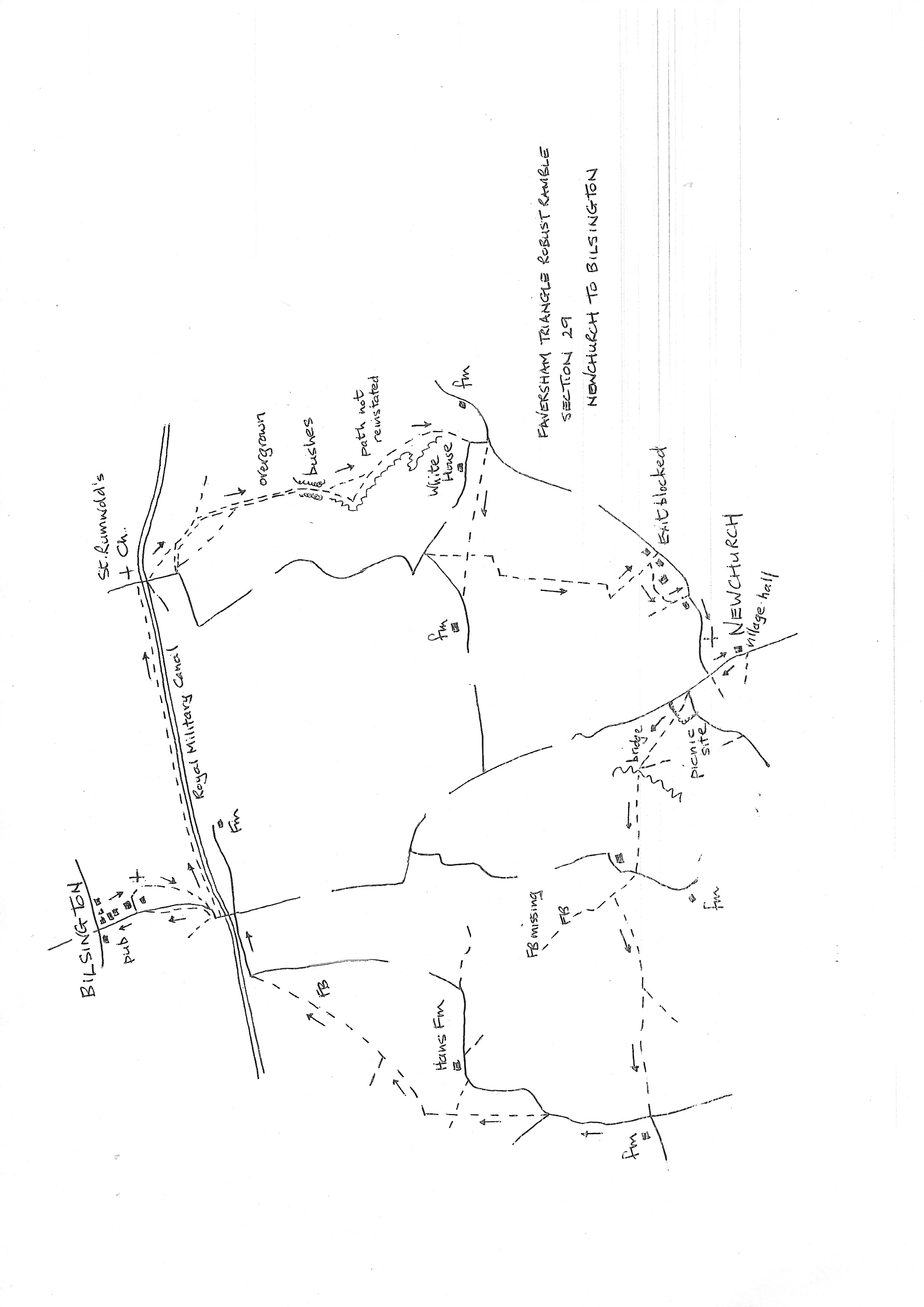
Section 29
Newchurch to Bilsington
Walk Details
Walk Instructions
Robust Ramble – Kent Triangle - Faversham – Wadhurst – New Romney – Faversham
Section 29 Out
Newchurch to Bilsington
OS Map: Explorer 125 Romney Marsh
Total Circular Distance: 7 miles/5 hours
Start: From Newchurch Village Hall. Parking is very limited in the village and the village hall locks its gates when not in use. There are a few spaces by the church.
Comment: This is really difficult walking country. Most of the traditional pasture has gone and, with it, long days of walking on grass. This walk is all across arable fields so hard baked tracks on reinstated paths across a variety of crops including peas, maize and rape. Some paths no longer exist so this has affected the route. In places, along the edge of fields, there is no attempt at reinstatement so it’s necessary to push along the edge of the crop. A suggestion is to move into the field a short way and walk a parallel tractor track. There are many stiles in various conditions, some extremely high. Bridges and stiles may be overgrown so carry secateurs. This walk is very exposed so take real care in hot weather and be prepared for downpours in wetter times. Happily the pub at Bilsington has reopened seven days a week so it’s worth the climb up and back.
With the village hall behind, turn right up the road. Pass a road off right to the church and keep on to the next junction by Newchurch Lane. Find and cross a footbridge into a picnic area, keeping on the middle path across to a picnic table and information board about the WW2 airfield here.
Exit into a field and go diagonally right, up to the left end of a bushy hedge and on to reach the Wallsfoot Sewer. Just right of the path find a substantial plank bridge.
Cross to go up by a pylon with a ditch on your right. Eventually emerge onto a road.
Cross and go over a footbridge concealed in the hedge. Continue up the field ahead.
Reach a stream and bear slightly left with the stream on your right and field on the left.
Reach a junction of paths, although the way ahead is very rough. Turn left on the path across the field. At a Y-fork keep right and finally emerge at a road junction. Turn right up the road.
At a Y-fork find a footpath in the Y and join it to go directly up the large field. Cross a cross path by a wooden telegraph pole and keep on to a footbridge at the top.
Cross and bear right across the corner of a field to a footbridge at the far side. Cross into a pasture and go diagonally left across. Funnel into the narrow top corner and cross an ancient footbridge.
Continue across the field ahead. Cross another old footbridge and bear right across to the far opposite corner. Exit through double fieldgates onto a road. Go straight up the road with a canal on your left.
At a junction turn left over a bridge. Just past the first house on the left, look for a gap in the hedge on your left. Drop down to cross a footbridge in to a rising field.
Turn right along the field edge and follow it around and uphill on the edge of the field; it gets rougher as it goes. Near the top of the hill drop, down right onto a road by a farm.
Turn left uphill to reach a T-junction. The White Horse pub in Bilsington is on the left and the end of the section.
Robust Ramble – Kent Triangle - Faversham – Wadhurst – New Romney – Faversham
Section 29 Return
Bilsington to Newchurch
OS Map: Explorer 125 Romney Marsh
Total Circular Distance: 7 miles/5 hours
Start: Very little parking in Bilsington except at the pub if intending to visit.
Comment: A pleasant start to the return along the Royal Military Canal which is treelined. These are the last trees on the route so no further respite from sun or rain. The crossfield paths are currently reinstated through crops but fieldedge paths generally not. There is a long battle along a very overgrown bridleway. Finally the good burghers of Newchurch exhibit little interest in their paths and the intended exit is blocked (an alternative is described). The views are good.
From the White Horse turn right off the main road down Newchurch Road, used in the outward route. In 60 metres look on the left for the blue noticeboard of Bilsington Church and turn into the concrete entrance to several venues. Go forward down a drive between tall green hedges to arrive at the small car park and church gates.
Go up to the church porch (well worth a visit) then right down to a wooden gate, then on across a lawn to a stile. Go diagonally right down a field to a road. Turn left a short distance to reach the bridge over the Royal Military Canal. Do not cross but turn left on the canal path.
Stay on this treelined way for a mile. Exit onto a road and turn right over the bridge.
Immediately turn left onto a footpath going diagonally down and across the field. Reach a footbridge at the bottom.
Cross onto a wide farm track. Stay on this track between fields. Pass a footbridge on the right and keep forward on the bridleway. This soon deteriorates into a very overgrown footpath; it is very slow going. In the distance is an isolated white house, this is the ultimate destination.
After an enclosed section emerge into the corner of a field. The path should go diagonally left across to a corner of a drainage ditch. Otherwise continue around the edge (no evident path now) and follow the ditch on your right for ½ mile to the very far bottom corner.
There is a telegraph pole in the corner. Turn right here a few paces then left straight up the field (amazingly currently marked out with a fingerpost at the top) to a road.
Turn left along to a T-junction. Just before the junction turn right over a footbridge and go on across the field. Cross a footbridge and bear slightly left across the next large field.
100 metres from the far side meet a cross path (do not take any notice of the many double tractor tracks which cross). Turn left on this.
Cross a footbridge and continue slightly leftwards for some way to finally reach another footbridge.
Over this turn immediately right for 20 metres to a third footbridge. Cross and turn immediately left down the field edge.
At the bottom corner the path should exit past a house onto a road. The way is obstructed and an apparent hostile environment.
Instead turn right around the field edge for 100 metres. Find a metal fieldgate on the left into an open area. Go through and straight down to a further metal fieldgate and down a drive to a road. This is a PROW.
Turn right on the road into Newchurch and continue past the church to a road junction. Turn left to reach the village hall and the start of the section.