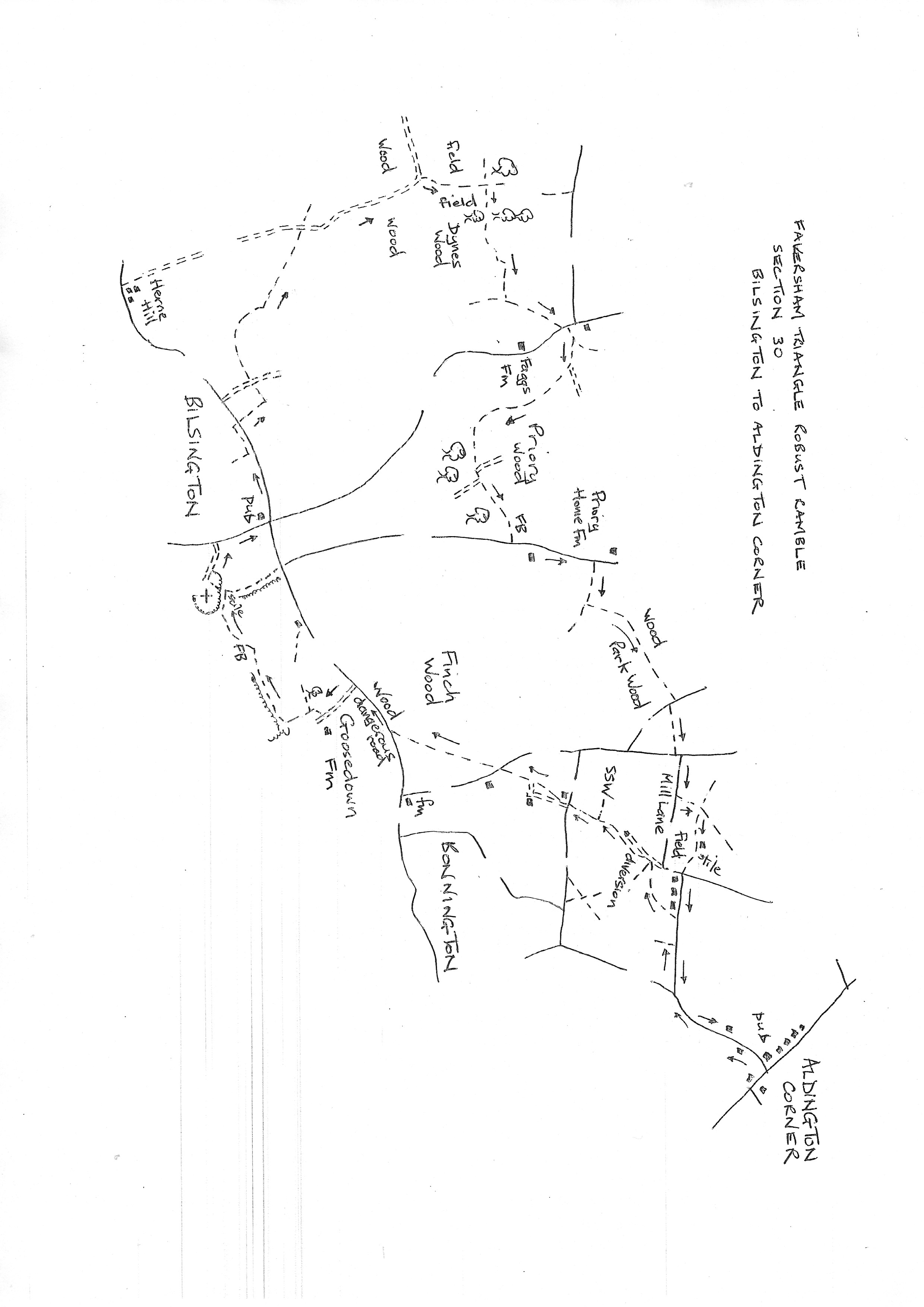
Section 30
Bilsington to Aldington Corner
Walk Details
Walk Instructions
Robust Ramble – Kent Triangle - Faversham – Wadhurst – New Romney – Faversham
Section 30 Out
Bilsington to Aldington Corner
OS Map: Explorer 125 Romney Marsh, 137 Ashford
Total Circular Distance: 8 miles/5 hours
Start: From The White Hart pub in Bilsington
Comment: Unfortunately it’s necessary to walk a short distance along the busy road, west out of Bilsington. If possible get into the field on the lefthand side. Although this section makes considerable use of the Saxon Shore Way, it is lightly used and needs careful attention to stay on route. The section passing Fagg’s Farm is not currently reinstated. There are crosstracks in the woodlands sections so use the map to get a feel for the direction of the path. There are some waymarks. There are stiles.
With The White Hart behind, turn left along the main road for 200 metres. Look for a footpath on the left. If possible go through the hedge and turn immediately right, parallel to the road. At the bottom of a dip, two metal fieldgates are reached. Exit through these onto the road. Cross and turn left to walk along with care.
In a short distance, look for a footpath going off right, over a stile into a field. Cross, and walk up the side of the field, away from the road, with a line of trees on your right.
Someway up the field, the treeline bends slightly right. Here turn sharp left and walk straight across the field, to cross a broken stile into a wood. Go forward, uphill, on a clear path.
Eventually this widens into an old vehicle track. Look out for a gap on the right which indicates the end of the wood; the track swings right to stay in the wood.
By a waymark post, turn left off the main track, and go steeply uphill to a stile in a gap at the edge of the wood. Cross into a field and turn right along the edge with the wood on your right.
Some way along, when level with two isolated trees on the left standing in the field, bear diagonally left, away from the wood, to go to the very top lefthand corner of this large field.
Here enter the wood and drop down a bank to a stile. Cross the stile to a shady byway. Turn right up it.
At a junction, bear right, down and over a wide footbridge. Continue up through trees to a wooden fieldgate and broken stile into a field.
Go ahead up the left side. Where the trees stop continue across the open field. On approaching a corner of woods ahead, look for a feint cross track (the Saxon Shore Way). Turn right on this.
At the bottom of the field cross a rickety stile into woods and go forward negotiating several large fallen trees. Cross a footbridge and eventually reach a metal gate and footbridge out to a field. Go straight ahead with a hedge on your left.
Keep up the edge of the field and soon go through a gap into another larger field. Turn right along the edge of the field and around left at the corner and continue some way down the edge to reach a footbridge on your right.
Here turn left, with the footbridge behind, and go straight across the field on a very feint path to the far right corner, passing a farm over on right as you go.
Exit onto a road and cross to farm entry opposite. Go down the first track on your right steeply into woods. Keep through these woods for half a mile. Ignore a footpath soon off left and keep on the SSW all the way.
On crossing a footbridge there are a number of paths. Bear slightly right uphill (currently there is a yellow waymarker). Eventually exit onto a road.
Turn left for ¼ mile. Opposite Priory home farm, turn right through a metal swing gate by double wooden fieldgates. Then on to a second metal gate into a field. Continue up the edge.
Just before a stile in the top corner leave SSW and turn left over a footbridge and metal swing gate into woods. Go forwards over a cross track and onto a clear path dropping down to a footbridge then on up again.
Basically keep on this smooth beaten path for ½ mile in a roughly straight line across the wood. Disregard side turnings and especially the crossing of rutted forestry vehicle tracks. The smooth beaten track varies in width and is sometimes used by horses.
Eventually drop down in to a ravine with a large water pipe. Here swing sharply left uphill to a stile onto a road.
Turn right for ten metres, then steeply left down steps to a footpath through woods. Exit onto a road. Turn left 39 metres then right into Mill Lane.
In 80 metres turn left over a stile by a wooden fieldgate into the Hayfield. Bear slight right uphill to a wooden telegraph pole.
Behind the pole is a stile into a rough field. Go up with hedge on your right. Soon reach an old gateway and go through into the field ahead. Continue along the top edge. Go through a metal swing gate by a barn and continue to a stile on the right.
Cross into a field and turn left across it to a stile by a wooden fieldgate out to a road junction. Cross to go forward up Mill Road.
At the top end turn left up the pavement on Forge Hill all the way up to the Walnut Tree pub in Aldington Corner and the end of the section.
Robust Ramble – Kent Triangle - Faversham – Wadhurst – New Romney – Faversham
Section 30 Return
Aldington Corner to Bilsington
OS Map: Explorer 125 Romney Marsh, 137 Ashford
Total Circular Distance: 8 miles/5 hours
Start: From The Walnut Tree pub in Aldington
Comment: A walk of constant contrasts and many short sections in and out of woods and trees and over stiles. The paths are not particularly well used so keep a close check on the route. Unfortunately, there is 200 metres on the busy B2067 into Bilsington with no apparent alternative either side. This needs enormous care as there are no significant verges and the traffic, as usual, passes at speed. If possible wear a Hi-viz waistcoat.
The Walnut Tree pub is on a main road with a recreation ground opposite. Turn right, off the main road, down the side of the pub on Forge Hill. There is a pavement.
At an S-bend at the bottom, turn right, across the road to go up Mill Road. Ignore the first footpath off left and continue for 120 metres. Look for a field entrance down on the left. Cross a stile by a wooden fieldgate, then down to a metal kissing gate into a pasture.
Bear diagonally right across to a wooden kissing gate and on to a stile by a metal fieldgate. Cross onto a tarmac lane and turn left down it. This is the Saxon Shore Way again.
Ignore the first footpath off left and soon reach a white, electric wooden fieldgate across the lane. Here is a new path diversion. Turn left across a footbridge and through a metal gate into a pasture. Bear right on a new footpath.
Soon cross a footbridge and continue past the house up on the right. Go through a gap in a hedge and bear right up to a second gap. Through this turn immediately left along by the hedge on your left, to a metal gate into trees.
The path is very overgrown through the woods. At a junction, ignore the stile and the path (the Saxon Shore Way) going off right, and continue down with the wire fence on your right to a stile at edge of the wood.
Cross into a pasture and go along by the hedge on your right. Cross a stile back into woods.
At the far side cross a stile and footbridge and keep down the left side of a wildlife area, with hedge on your left towards the left end of a house ahead. Exit through double gates onto a road.
Cross straight over and continue on a gravel drive. Soon ignore a footpath off left. Turn right through a wooden fieldgate and immediately left, to follow a wire fence on the left up the edge of a pasture towards a white house.
On reaching the house, turn right down by a hedge and left at the bottom, over a stile, and on along the edge of paddocks.
Cross another tall stile and then a footbridge. Continue across the foot of a garden to a further stile out to a road. Cross to a stile opposite.
Cross a field slightly diagonally left, to the left end of trees ahead. Reach a stile by double metal fieldgates. Cross to a main road. Turn right with great care for 200 metres. STEP OFF THE ROAD IF VEHICLES APPROACH. There might be a path down the woods on the right but no access is evident.
On a dangerous bend, cross and turn left down the concrete drive to Goosedown Farm. Just before the farm, bear right into a large field.
Follow the wire fence on the left (there is no waymarking of the path here) and go down to the bottom corner, then bear right along the bottom edge of the field for some way, to the far corner.
The field edge turns right here back to houses on the main road. However, if possible, go left over a dilapidated bridge, and follow the field edge up towards the church on the hill.
In the top corner turn left over a stile into a pasture surrounding the church (this is back on a PROW) and bear right up to a further stile into a small car park area.
Turn right on the drive and go out to a road. Turn right on this up to a T-junction with the White Horse pub on your left and the start of the section.