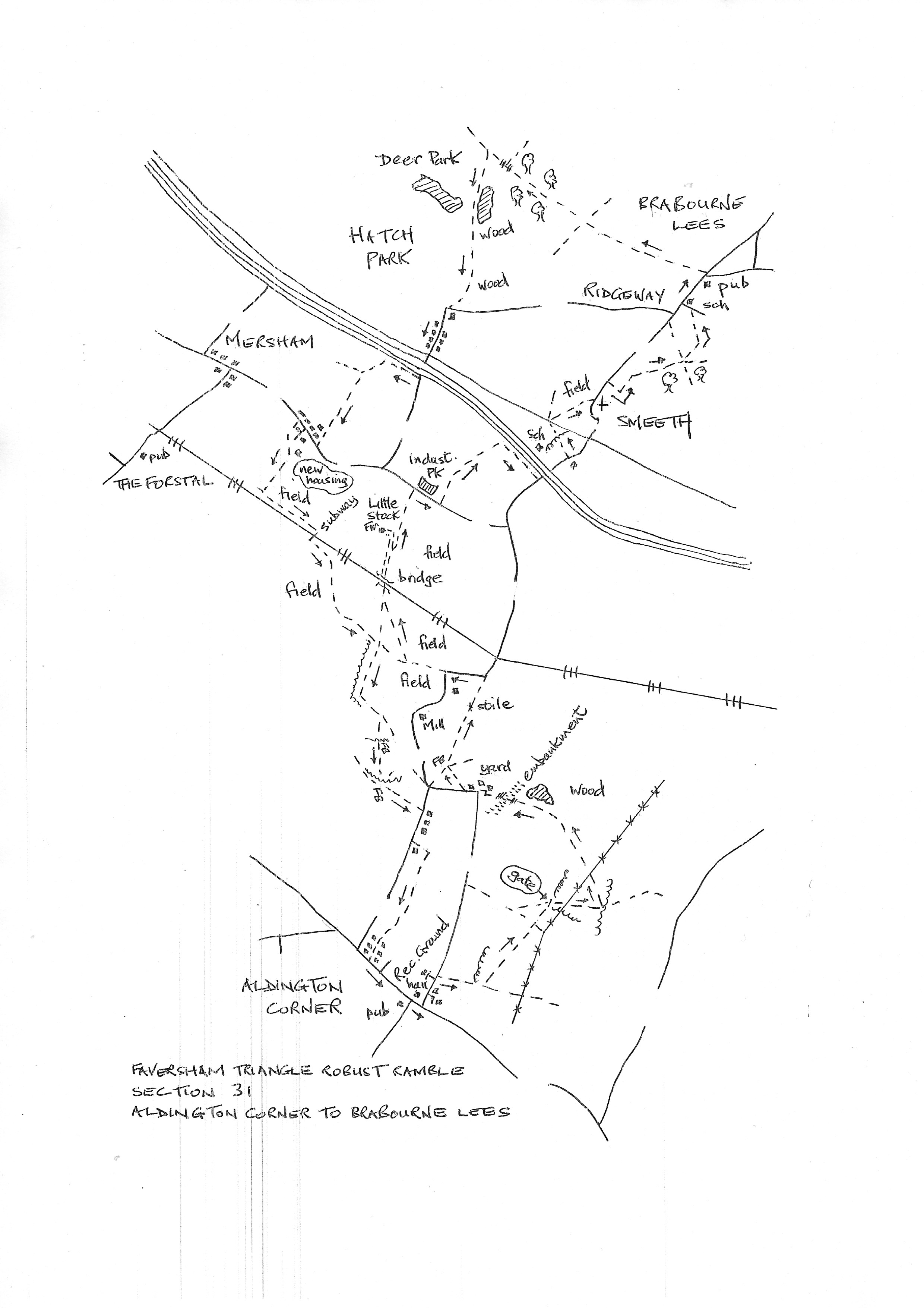
Section 31
Aldington Corner to Smeeth
Walk Details
Walk Instructions
Robust Ramble – Kent Triangle - Faversham – Wadhurst – New Romney – Faversham
Section 31 Out
Aldington Corner to Smeeth
OS Map: Explorer 125 Romney Marsh, 137 Ashford
Total Circular Distance: 9 miles/6 hours
Start: From The Walnut Tree Inn in Aldington Corner; plenty of on street parking
Comment: Quite a strenuous section mainly across large grassy pastures or cultivated fields. There are few moments of long, continuous so there is a need follow the instructions and the maps closely. Most of the paths are evident, with the usual exceptions where new building has caused a path diversion. Not always signed. There are stiles, a couple very high, and a few short stiff climbs. Thankfully The Woolpack Inn in Smeeth has so far survived closure.
With The Walnut Tree Inn behind, cross the main road to the playing field opposite. Turn right along the road past the Village Hall, and immediately turn left down the side road (Goldwell Lane).
Walk out if the village passing Church View on your right. A little further on, opposite Goldwell Close, turn right, off the road, through a swing gate by a metal fieldgate, into a field corner.
Go forward along the edge of the field with a fence oin your left, towards a distant church tower.
In 100 metres, the fence turns a corner. Here turn left, but rather than following the fence, bear diagonally right, downhill, towards a pylon below.
In the far bottom corner, cross a footbridge. Immediately turn right through a metal fieldgate into a field corner. Go ahead, across the centre of the field, leaving the hedge on the right, and passing under power lines.
At the far side meet a hedge sheltering a gate. Do not go forward here but turn leftwards 120 degrees, to face back across the field just crossed.
Go slightly diagonally right across the lower part of the field passing a pylon on your right. In the bottom corner go through a metal swing gate and cross a footbridge.
Continue slightly diagonally right across the next field to a metal swing gate in the hedge ahead. Enter a path enclosed between bushes.
Pass a pond on your right (presumably fishers responsible for the litter), and reach a stile by a metal fieldgate. Cross and go forward up concrete steps to a track on the top of the bund (this is part of a flood defence scheme).
Cross the track and descend more concrete steps the other side. Reach a metal kissing gate and, through this, a footbridge. Go forward to pass down the side of buildings to a drive. Turn left a short distance to a road.
Turn right along the road, past a bungalow. Reach a field corner. Go into the field and bear diagonally left across the field to a loing wooden footbridge at the far side, with a white house beyond.
Over the bridge, turn diagonally right across and up the field to a stile and long footbridge in the top corner. Cross in to the field beyond and bear right, up the side, passing a substation over on the left.
In the top corner exit up steps to a drive. Turn left to a stile by double fieldgates and reach a road. Turn left along the road for 50 metres.
Where the road bears left, go straight ahead, between logs, and on, across the field to a metal swing gate and footbridge. Over these continue in the same direction.
Halfway across this new field, turn diagonally right up to a bridge a cross a railway (no indications of this path) at the very top of the field.
Cross the bridge and continue on a gravel track towards Little Stock Farm up on the left.
Just before reaching the farm, go through a metal fieldgate on your right, into a field. Turn sharp left to follow the fence on your left. Where this swings away left, keep forward, across the field, to a stile onto a road.
Turn right along the road. Pass buildings and the entrance to a business park on your left. Reach a passing place. Here turn left into the field, through concrete blocks. Turn diagonally right across the field to the top opposite corner. Cross two stiles to emerge onto a road.
Turn left to cross the motorway. In 75 metres, cross a stile on your left into a school sports field. Across the other side is a conifer hedge. The path should go diagonally right across the pitch, through the conifers then on, still diagonally right, to a stile onto a main road just before white gates, at the very end of a very scrubby area.
Try the left end of the conifers, or fight your way through further up. There is a waymark and stile where the path reaches the main road.
Cross the main road to a footpath off over a footbridge. Go diagonally right up the field towards houses then towards a church when this appears. Cross out to a road and cross the road to the pavement at the church gates (worth a visit).
Turn left up the road. Just past the last house on your right, turn right through a metal kissing gate into a field corner. The path is diverted here. Go sharp right up by the hedge on your right. At the top cross a stile by a fieldgate. Turn immediately left to go along by the fence on your left.
Leave the fence and cross diagonally right to the wood up on your right. Keep ahead down the side of the wood. At the end, by a metal kissing gate on your right, ignore the path turning immediately left, and go ahead, slightly diagonally left, towards houses.
Reach a black metal kissing gate. Go through and down to a second one. Through this turn left. Soon join a side road and continue up past a school to reach a main road.
Turn right a short distance to reach The Woolpack Inn in Smeeth and the end of the section.
Robust Ramble – Kent Triangle - Faversham – Wadhurst – New Romney – Faversham
Section 31 Return
Smeeth to Aldington Corner
OS Map: Explorer 125 Romney Marsh, 137 Ashford
Total Circular Distance: 9 miles/6 hours
Start: From The Woolpack Inn in Smeeth; ask about using the car park.
Comment: A rather more varied countryside for the return. However the paths east of Mersham and The Forstal are complex and not easy to follow across huge cultivated fields so it is necessary to follow map and compass directions very carefully.
With The Woolpack Inn behind, turn right up the main road used before and signed to Brabourne Lees; ignore the road off to the right.
In a short distance, turn left off the road on an enclosed path. This continues along the top of a field. Reach and go through a wooden kissing gate, then continue in the same direction with the hedge now on your left.
At the end of the pasture drop down to a stile into an enclosed path between fences.
At the bottom of the slope go through a metal swing gate and over a footbridge, then up a bank to a stile. Ignore the path off left, and go diagonally right across to a metal swing gate in the hedge.
Through this, cross a track to a second gate into a large field. Bear diagonally right across it. Cross a stile at the far side and head into trees.
At the far side of the wood cross a ladder stile into a deer park. The route a little confusing here as there are several paths.
Go forward a short distance to arrive at a junction of grassy paths. Turn left here. You should soon reach a sunken, reedy lake on your left. Continue past the lake then on, up by woods on your left.
After some way pass through a deer gate. Continue, looking out for the path going steeply left, up the bank, to a gate out onto a road, with a house opposite.
Turn right down the road to reach a junction with the A20 main road. Cross, and continue down the narrow side road opposite to reach a bridge over the M20 motorway.
Immediately over the bridge turn right over two stiles into a field. Keep along the field edge with the hedge on your right to the corner ahead. Go into the next field and continue as before with the motorway below.
In 50 metres bear left into the field, away from the edge, bearing slightly diagonally right. In midfield, turn left, off this diagonal path and head straight across to the left end of houses at the very far side. The path might be reinstated through crops – or not.
Pass down the side of the end house to a road and turn right. Just past Quarry View on the left, turn left onto a track behind a heavy metal gate.
Cross a stile and turn left, to follow the fence towards buildings. Pass these on your left and continue down fields to a gate, then on down to the bottom with a railway beyond.
Here turn left along the bottom of the field for some way. The railway and hedge are on the right. At the very far end, drop down to a stile by a metal fieldgate. Cross and follow the track down and to the right, under the railway lines.
At the far side reach a metal fieldgate, ignore this and turn left to another metal fieldgate. Go through this and cross the field to a metal swing gate in the hedge opposite, the railway is on your left.
Continue across the next field towards a distant white house. At the far side reach and go through a metal fieldgate into a sloping field. Notice a railway bridge up on your left, and a path going straight ahead across the field.
Instead, turn right, down the edge of the field with a hedge on your right. Follow the hedge down then left. The hedge (and stream) soon swings right again. At this point bear diagonally right down and across the corner of the field to a footbridge in the middle of the bottom hedge (this is not quite as marked on the OS map but arrives at the same place).
Over the bridge two paths diverge to the left. Take the righthand one across the field.
Cross a footbridge at the far side and turn immediately left along the stream on your left. Where this swings left keep straight on, directly across the field to the far corner. Exit onto a road and turn right.
In 100 metres, look for a footpath off left through a gate into an enclosed path. This soon reaches an ornate metal kissing gate into a pasture. Turn sharp right, up through trees, to a footbridge and stile. Cross into a sloping pasture.
Bear diagonally left, uphill, to the far top corner. Cross the righthand of two stiles – the very tall one – then up steps to a field. Follow the path going straight ahead up to houses.
Continue straight ahead through the houses, sometimes on roadways, sometimes on little sections of path, to reach a junction with the main road in Aldington. Turn left to return to the Walnut Tree Inn and the start of the section.