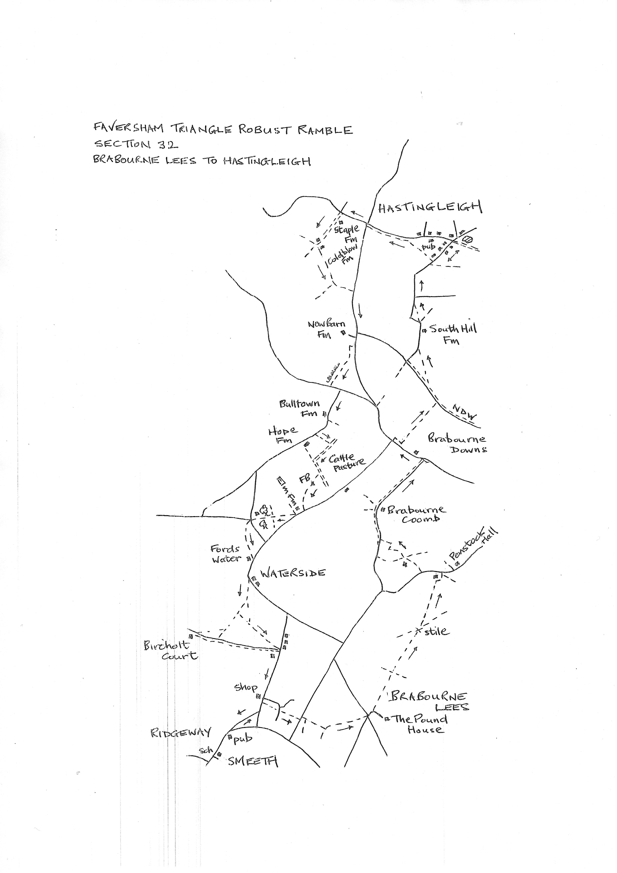
Section 32
Smeeth to Hastingleigh
Walk Details
Walk Instructions
Robust Ramble – Kent Triangle - Faversham – Wadhurst – New Romney – Faversham
Section 32 Out
Smeeth to Hastingleigh
OS Map: Explorer 125 Romney Marsh, 137 Ashford
Total Circular Distance: 8 miles/5 hours
Start: From The Woolpack Inn in Smeeth, limited onstreet parking, or ask at the pub.
Comment: This is quite a tough section with some steep climbs and several stiles. Take care to stay on route as the way is not always easy to see. Sadly the village shop in Hastingleigh is closed and the pub only opens in the evenings in the second half of the week. Carry provisions.
From The Woolpack Inn turn right on the main road to Brabourne Lees. Walk uphill then down, passing The Lees Close on the left and soon reaching a junction with a green beyond.
Keep forward up Lees Road. Just before a shop, turn right over the road to an enclosed footpath with holly bushes.
Drop down, then up to cross a residential road and continue forward to eventually reach a T-junction with a road.
Turn left for 15 metres then look right for a narrow, enclosed path. The stile is broken and it is extremely difficult to cross.
Soon enter a scrubby field and continue down with a hedge on your left. In the bottom corner the path goes left through bushes to two footbridges into a rising meadow.
Go diagonally left uphill. At the top go through a metal swing gate and on across to a metal kissing gate out to a road.
Turn left a few paces to a junction. Ignore roads off right and left and cross straight over to a private drive ahead.
On a bend go left over a footbridge and straight on up the field. At the far side reach, and cross, a footbridge. Continue up the next field, slightly right of a lone tree. Reach a metal swing gate and footbridge into the field beyond.
Bear slightly left across this field, brushing the end of a hedge in midfield. Continue towards a white house, going down the side of the garden and around the rear to a road.
Turn right up the road. In 50 metres turn left through a narrow gap in the hedge to an old stile, then on up the field by the fence on your right to a high stile at the top. Cross, and bear left down to a stile in the bottom corner.
Cross a further paddock to a flimsy stile, then on, to the right end of a conifer hedge.
At the end of the line of conifers, turn right into trees and soon reach a footbridge with both a stile and a gate.
Go across the end of the field a short distance to a corner of woods not far ahead. On reaching it continue up the side of the field with the wood on your right.
At the next corner turn right into the trees to a metal swing gate and footbridge onto a rising path through the wood.
At the very top of the wood, turn left, along the edge, to a metal swing gate and footbridge leading to a byway. Turn right, uphill.
Pass through a farm and on, now a tarmac road, to a T-junction at the top. Turn left along the road for 150 metres. Pass a farm and eventually reach a road junction.
Here turn right up a steep bank (this is a path diversion from earlier maps) into a steeply rising field. Turn sharp right along the bottom edge of the field to a corner then left, still up the edge of the field with a hedge on your right.
After a stiff climb, go through a metal kissing gate by a metal fieldgate at the top, and on along the edge of the field ahead. Reach another metal swing gate and turn left on the North Downs Way.
In 100 metres look on the right for a metal swing gate by a metal fieldgate. Go through and turn diagonally left across a large undulating pasture to a metal kissing gate in the far hedge. Emerge onto a road and turn right.
Pass a farm and reach a sharp left bend. Here go through a metal fieldgate and bear diagonally left downhill to a metal kissing gate onto a road.
Turn right on the road and head uphill (ignore side road) towards Hastingleigh.
Pass between houses and eventually reach a road junction by a pond. There are seats here.
The village shop and pub,The Bowl Inn, were down Tamley Lane on the left. The shop has closed and the pub is only open Thursday to Sunday from 5.00pm. So the pond is the end of the section.
Robust Ramble – Kent Triangle - Faversham – Wadhurst – New Romney – Faversham
Section 32 Return
Hastingleigh Smeeth
OS Map: Explorer 125 Romney Marsh, 137 Ashford
Total Circular Distance: 8 miles/5 hours
Start: From the pond in village centre, no obvious parking here.
Comment: There is some very difficult going on this section where the route steeply descends the North Downs and then runs across a cattle farm. It is necessary to use the farm tracks to approximate where the footpaths would have run. The following section from Elm Farm is also rough. However the problems are not over as sheep pastures have to finally be negotiated and, once more, the footpaths are not evident and the prominent farm tracks do not follow their line. Several options are offered.
With the pond behind, go back down the road used to enter the village. Just past Rose Cottage on your right, go right, up steps, to a metal kissing gate in the hedge. Head straight across the field by the hedge on your right.
At the top end go through a metal kissing gate and, briefly, through trees to a vast field. The path should go diagonally right across the field corner to some road signs below, then on along the bottom field edge with a hedge on your right (most people stick to the edge all round).
At the end of the field exit onto a road and turn left to a crossroads. Go straight across on the road signposted to Wye.
In 100 metres, just past last house on the right, go up a lane to Staple Farm. Pass this and continue to extensive buildings of Cold Blow Farm. At the far side turn left onto an enclosed path now the North Downs Way.
Reach a junction of Kissing gates and turn left across a field, still on the NDW. Exit via a metal kissing gate onto a road and turn right for some way.
Ignore a side road off left and continue uphill. At the top, just past the entrance to New Barn Farm, go through a metal kissing gate on your right, into a pasture (excellent views here). Be careful to check your direction on this steep descent. Do not veer left.
Bear slightly right downhill. Over the brow there is a sunken path to follow, steeply down to a metal kissing gate in the bottom corner. Near the bottom the sunken path disappears into bushes, so some small diversion is needed.
Exit onto a road and turn left. Soon reach a junction at Bulltown Corner and turn right on a side road to Bulltown Farm. Pass the farm on the right and a house on the left. Now turn left over a stile by double metal fieldgates. The next stretch is difficult as this is cattle country with no signage and little evidence of paths.
Go forward into a field and continue up by the fence on your right. Keep along to the far corner. Here turn right on a wide rough farm track and go downhill.
At a junction go left still on the farm track (the farm is over on your right). Follow the track down to a left bend. Here turn right into a rising field (a redundant footbridge on the right shows the original line of the path).
Go diagonally left uphill across the centre of the field to two stumpy posts at the very top (ignore a similar pair more sharply left). Go through (a simple cable to undo) and continue in same direction to the top far corner of the field and a stile onto a road.
Turn right on the road. In a short distance, pass Elm Farm on your right, and reach a stile on the right, into a field. Bear left across the field, passing a telegraph pole.
At the far side, go forward, down between two rows of stunted trees to a metal kissing gate at the end. Pass by buildings.
In the next paddock, bear right, down to a metal kissing gate in the corner. Go through and over a footbridge (currently flooded but passable) and out to a road.
Cross to a field entrance opposite and a stile by a metal fieldgate. In the field beyond the path goes diagonally left to the far bottom corner (you may have to work around an electric fence in mid-field).
In the far corner are two stiles. Ignore the one on your right and cross the left stile into a pasture. Bear diagonally right across to a further stile. Over this, onwards to a final stile in the far corner and out to a road. Turn right.
On reaching the first house on your left, turn right, over a footbridge, into a field. This final stretch of path is difficult to follow due to livestock fencing for sheep pastures.
From the footbridge, bear diagonally left across the pasture to the end of a hedge. Pass it and keep on diagonally left upto the left end of the hedge beyond.
Go through a temporary rope barrier onto a farm track. Turn left to soon reach a junction of tracks. (The PROW actually goes diagonally left here in a straight line to a stile in the far opposite corner. However there is no evidence of it across the sheep pastures). The suggestion is to turn uphill on a farm track with a hedge on your left.
The easiest option is to go to the very top of the track to a junction. Here turn left on a vehicle drive and walk down to a main road.
Otherwise, before reaching the top of the hill, look out for an opening through the hedge into the field on your left. Go straight across the field with a fence on your right. At the far corner, cross (possible gate to climb) into a field with houses beyond.
Turn diagonally right upto a stile in the far top corner leading out to a main road.
Turn right along the road for half a mile back into Smeeth. Pass the village shop on your right halfway. Turn right at the junction beyond and continue up and down to return to The Woolpack Inn and start of the section.