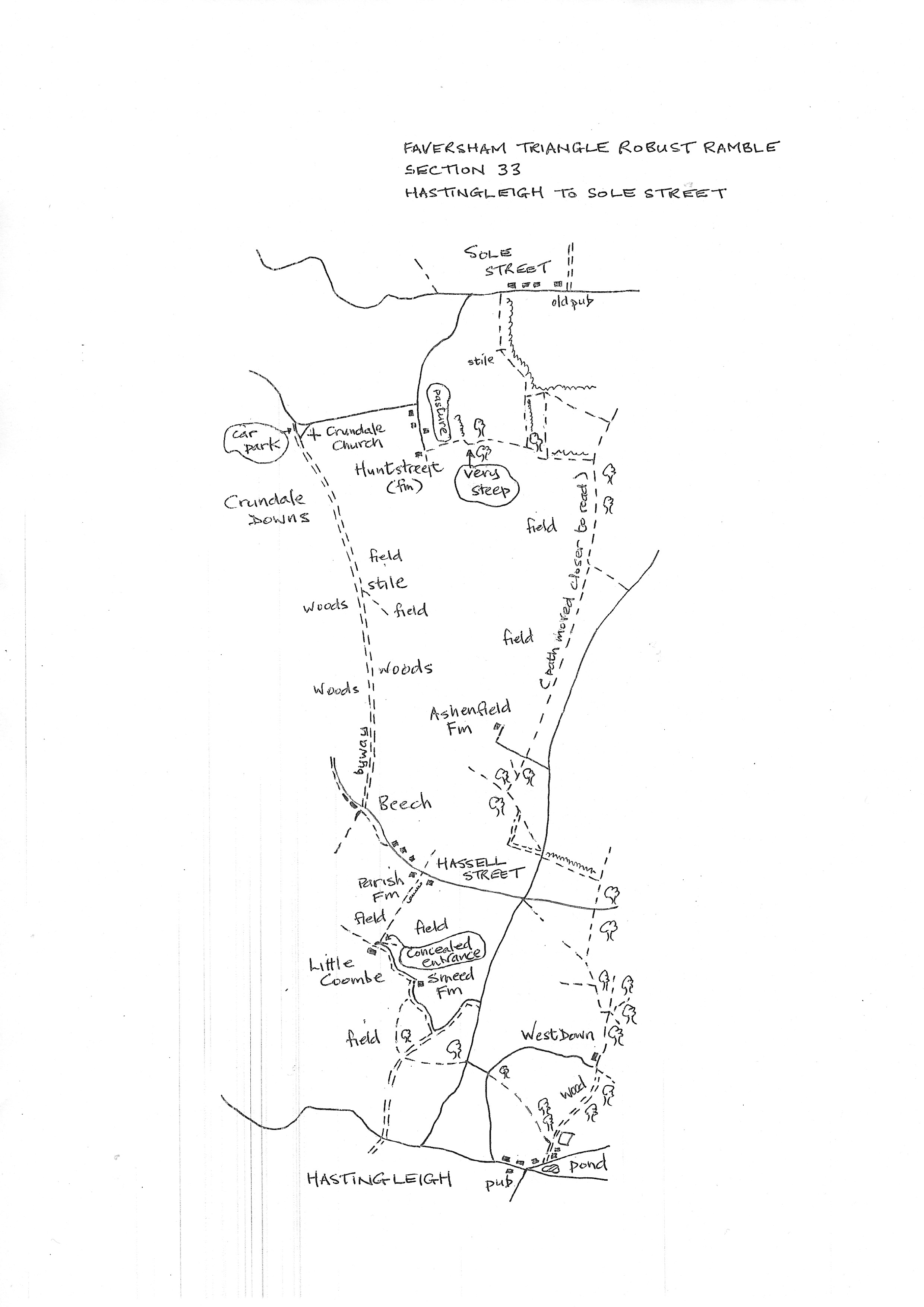
Section 33
Hastingleigh to Sole Street
Walk Details
Walk Instructions
Robust Ramble – Kent Triangle - Faversham – Wadhurst – New Romney – Faversham
Section 33 Out
Hastingleigh to Sole Street
OS Map: Explorer 137 Ashford
Total Circular Distance: 8 miles/5 hours
Start: From the pond and crossroads in village centre. Parking is very limited. The pub is only open Thursday to Sunday.
Comment: This route is fairly straightforward. The original route looked more varied and interesting but the path through woodland was dangerous and impossible to find on the ground. There is a short but very steep pull up to the final stretch into Sole Street. Sadly the pub in Sole Street is currently closed and there are no other facilities there. Carry provisions.
From the north side of the pond in Hastingleigh turn right on the road heading out of the village past a gothick style house called Southview.
A short distance up the road, turn first left up a gravel farm track passing houses over on your right.
Pass the entrance to a playing field also on the right. In 10 metres further, leave the track going straight ahead, and turn left into a field entrance.
Follow down the edge of the field with a wood on your right. Where the trees finish, continue steeply uphill on a grassy track.
Go forward into a further field at the top, with a hedge on your right. Keep on, past woods on the right, until the path finally bears right into the trees and soon emerges at a road junction.
Ignore the ‘no through road’ down to the right and go forward on the main road, past a house on the right.
At a T-junction. Go straight across to a path by a metal barrier. Go forward along the field edge with trees on the right.
Where trees end, continue across an open pasture to meet a lane. Cross into the field entrance opposite.
Turn right on a feint path, down past a tree on your right to Smeeth Farm in the valley bottom below.
Exit through a hurdle at the bottom and reach a road. Turn left and follow around, to Little Coombe house on the left.
Opposite the side gate of the house a feint path goes right through bushes then a patch of scrub, down to a field corner.
Ignore the path off right and go straight ahead, uphill, following a line of poles and wires.
At the top continue ahead alongside a hedge, then down past a barn and by double metal barriers to a road at Hassell Street. The path ahead is currently impassable, so turn left along the road.
After the last house on the right, continue forward on a country lane. Just before trees on the left, reach a crossing of ways. Ignore footpath down left and turn right on a byway along into trees.
Stay on this byway for over a mile. Halfway pass a stile into a field on the right. Continue on the byway across Crundale Downs to finally emerge at a car park and road.
Turn right on the road passing Crundale Church (worth a visit). In ¼ mile road drops down and turns sharp left. Here turn right on a lane to Huntstreet.
Go down between houses to a farm at the end of the lane with a concrete track and gate ahead.
Here turn left on a bridleway through a rusty fieldgate and go steeply up the edge of a pasture with fence and trees on your right.
At the top corner turn right, through a wooden fieldgate, then immediately left very steeply up through an area of scrub.
Go through an equine gate at the top into a wood.
Soon emerge into a field and go straight across. At the far side leave the bridlepath and turn left up the field edge with a hedge on your right.
Keep going to the very top corner of this large field (ignore a gap off left halfway). Cross a stile by a metal fieldgate and continue through trees then on, up a pasture to a metal swing gate out to a road.
Turn right on the road to reach the currently closed pub in Sole Street just past a small 4 vehicle car park and parish notice board on your left. This is the end of the section.
Robust Ramble – Kent Triangle - Faversham – Wadhurst – New Romney – Faversham
Section 32 Return
Sole Street to Hastingleigh
OS Map: Explorer 137 Ashford
Total Circular Distance: 8 miles/5 hours
Start: From the closed pub in Sole Street. Limited on street parking.
Comment: This is quite a difficult section as several long sections of paths have been diverted or moved to the field edge. The latest changes are shown on the OS map app. But may not be on paper maps. Some of these diversions are not reinstated through crops. Sadly, the village shop in Hastingleigh is closed and the pub only opens in the evenings in the second half of the week. Carry provisions.
With the former ‘Compasses’ pub behind, turn right (west) along the road. Pass the last houses on your right then in 15 metres turn left into a pasture through a metal swing gate by a metal fieldgate.
Goi forward along a hedge on the left. Reach and cross a rickety stile by a metal fieldgate and continue along with the hedge on the left. It gently swings left up the side of a huge field.
At the top of the rise, turn left through a gap into a field corner. Go left on a diagonal path across the centre of the field, but only for 50 metres. Then turn right straight down the field to the tallest tree in the bottom hedge (this path is not signed or reinstated through crops, but there were tractor tracks to use).
Leave the field at the bottom on a feint path just left of the tall tree. Reach a T-junction with another path just the other side of the hedge.
Turn left and walk along a field edge with a hedge on your left.
At the corner ahead turn right still along the edge of the field with trees on your left, for some way.
At a gentle bend left the path continues down to a road. Do not turn left, but go straight ahead down a long field, parallel with the road down on the left, aim left of the farm in the distance ahead. (This path used to go directly to the farm but has been moved to the left, however currently not reinstated through crops).
At the far end of the field reach a wire fence. Look for a metal swing gate by a lone bush and enter an enclosed and overgrown, path.
Emerge through a wooden swing gate to a drive. Cross to a second swing gate and go up the side of a paddock to a metal swing gate into woods. Goi forward on a feint twisting path.
Merge into a clearer path and continue downhill. Reach a tractor track and turn left along to a field corner.
A footpath should go diagonally right up and across the centre of the field to the far opposite corner (currently not reinstated). Otherwise turn right with the farm track along the side of woods. Turn left at the field end, still with the track, up to a gateway onto a road.
Turn right a few paces, then left around a barrier into a field corner. Keep left along the field edge with a hedge on your left.
In the top corner, join a bridlepath and turn right along the top edge of the field with trees on your left.
Reach a road. Cross and continue up the edge of a rising field. At the top go through an equestrian gate and bear left across a corner to a wood.
Follow a pleasant path zig-zagging through trees. Reach a wooden equestrian gate and a T-junction with another bridlepath. Turn right on this (ignoring other paths slanting off into trees ahead) into an enclosed path between hedges.
Leave the woods through an equestrian gate and go steeply downhill.
Pass an impressive farmhouse on the right at the bottom of the dip and begin to climb on a grassy track. Reach and go through a wooden fieldgate. Immediately come to a fork, bear right, steeply uphill (not a PROW but a well-used local track).
At a Y-fork bear left still upwards on the main track. At the top of the hill emerge from the woods by a playing field on the left.
Keep forward onto a farm track emerging from the field on your right. Pass houses on the left and reach a road.
Turn right a short distance to arrive at the village pond in Hastingleigh and the start of the section.