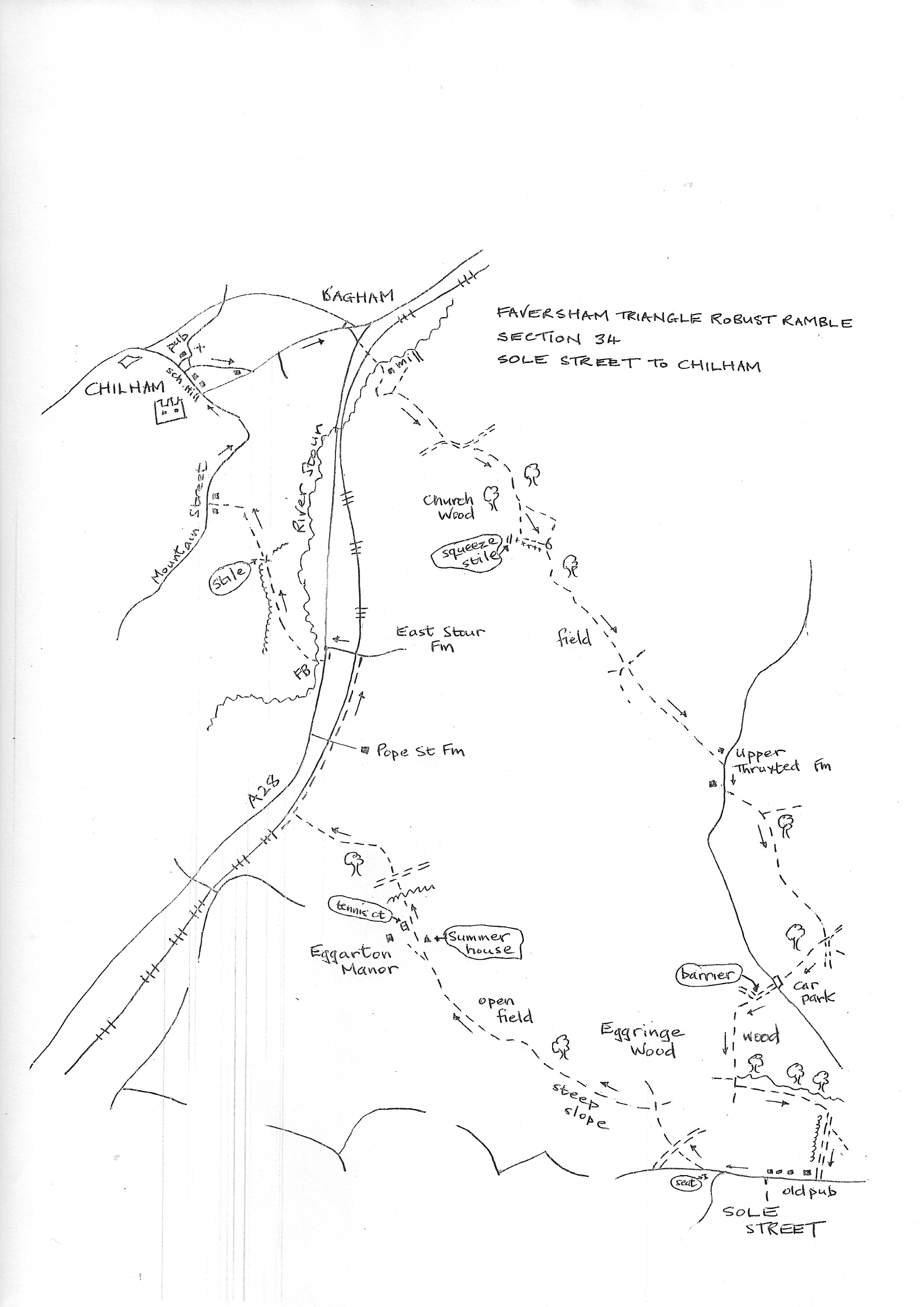
Section 34
Sole Street to Chilham
Walk Details
Walk Instructions
Robust Ramble – Kent Triangle - Faversham – Wadhurst – New Romney – Faversham
Section 34 Out
Sole Street to Chilham
OS Map: Explorer 149 Sittingbourne & Faversham
Total Circular Distance: 9 miles/5 hours
Start: Sadly the pub at Sole Street, Shepherd Neame of course, is currently closed. There is a little on-road parking but no other facilities.
Comment: An interesting route on a variety of terrains, some stiles. Last leg into Chilham a bit tedious but there are views of the castle.
With the old pub building behind, turn right along the road, west, towards Crundale and Godmersham, passing houses on your right. Pass a sideroad off left (bench seat at the junction) and in a further 80 metres, turn right onto a footpath by a metal fieldgate and continue up into woods.
Reach a byway and go straight across, past a wooden fieldgate.
At a wooden kissing gate turn left through it and continue to an open area with a steep drop on the left. At a Y-fork bear left, slightly down but always just under the top of the escarpment. Go through bushes and on, just under a fence up on your right.
Enjoy the views before going through a wooden kissing gate and on into woods.
Eventually leave the wood and bear right and down and across scrub and pasture. Stay on the grassy track.
On approaching Eggarton Manor, down on the left, reach and cross an unpleasant stile and keep forward above the manor, passing a summer house on your right and a tennis court down on your left.
Keep across the top of the tennis court and go through a cherry tree in the hedge just below a rusty old fieldgate in the corner above. Behind the tree is a concealed stile. Beyond is a track. Cross this to a field and go forward along the edge on a track with trees on your left.
Keep on up a second field edge, steeply up to the top. Cross a footpath on the crest and continue down the field edge (this is a path diversion, the route used to go diagonally right across the fields to Pope Street Farm).
Pass through trees then down a field edge again to the very bottom where a railway line is evident. In the bottom corner go up the bank to an equine gate and turn right on a gravel path and cycleway along the side of the railway, which is on your left.
Cross a road and continue by the railway. At the next junction with a roadway, turn left down and under the railway and go forward to meet the A28 main road.
Turn left along the verge for 30 metres, then cross with care to a path opposite into a field through a wooden kissing gate and footbridge.
Turn diagonally right across the centre of this large pasture to a corner of hedge on your left at the top, then continue to follow the hedge and fence on your left all the way to a gate into the next pasture, and on to a stile on the left.
Cross into a field and go diagonally right across the centre. At the far side enter an enclosed path, soon out to a road called Mountain Road.
Turn right and follow this for some way to the outskirts of Chilham village. At a junction bear left up School Hill to the village square and turn left across it to the White Horse pub and end of section.
Robust Ramble – Kent Triangle - Faversham – Wadhurst – New Romney – Faversham
Section 34 Return
Chilham to Sole Street
OS Map: Explorer 149 Sittingbourne & Faversham
Total Circular Distance: 9 miles/5 hours
Start: Public car park at the foot of Taylors Hill just off the square in Chilham. Start from the White Horse pub.
Comment: An interesting route on a variety of terrains, some stiles. Problems with the path in Church Wood. The path across a field is now straight and easy but may look meandering and devious on older maps.
From the square in Chilham, pass down the side of the White Horse pub towards the church. Bear right past the church over on your left and go down The Street.
At the foot of the hill, at a junction by a pub on the right, bear left along the road. Head on out of the village. Eventually come close to a main road on your left, the A252. Do not go up to join it.
Keep bearing right on the minor road, then sharp right along by houses on your left. Soon reach another main road, then A28.
Cross this with care and go up Mill Lane opposite. Cross railway lines and continue up the lane. Pass a really impressive mill building over on your left.
Continue over the river, then bear left with the track, along past a house on your right. The track becomes a footpath turning up through trees.
At a Y-fork keep right and forward up through woods to emerge into a field. Continue along the field edge with a hedge on your left.
Continue across the open field to a corner of a wood. Meet and go forward on a restricted byway. Where this bends left, bear right, around a metal fieldgate, and then diagonally left up, and across, a rising field.
Enter Church Wood at the top and continue on to a metal kissing gate, then on in same direction.
Go through a metal swing gate, then still on up.
(A PROBLEM NOW. THE OFFICIAL PATH SHOULD GO OFF DIAGONALLY LEFT THROUGH THE TREES. ON MEETING A TRACK IT TURNS RIGHT. IT CONTINUES SOUTH THROUGH THE WOODS TO A METAL KISSING GATE. IF THIS ROUTE IS NOT EVIDENT THEN USE THE FOLLOWING INSTRUCTIONS).
Near the top of the rise reach an open grassy area. Bear slightly right and forward on a grassy path across scrubland (not a PROW but waymarked).
At the far side reach metal fieldgate and a squeeze stile next to it. DO NOT GO THROUGH but turn left along the wire fence, now on your right, into trees. Look ahead to see a metal kissing gate.
Go through, now rejoining the official public footpath. Continue through woods for some way.
Eventually reach a stile into a large field and go straight across the centre.
Reach a complicated junction including a bridleway. The junction seems to have been rationalised. This Robust Ramble goes straight across the junction into a field (the OS map suggests a dogleg right and left). It then goes forward in a straight line to an enclosed path dropping down to the road at Upper Thruxted Farm (instead of making a curve left).
Turn right along Penny Pot Land for 100 metres, passing former pub, to reach a footpath off left.
Leave the road to go straight across a field to a gap in the hedge ahead, then on on a rough path through bushes.
At a Y-fork bear right and continue on through woods to a T-junction with a track. Turn right on this.
Emerge onto a forest access drive. DO NOT JOIN IT. But turn sharp diagonally right back into the woods on your right.
Reach a car park and go over to a road. Cross straight over this road to continue up a gravel byway. At a junction, ignore a track off right through a barrier, instead keep forward through woods for ¼ mile.
Keep forward where the wood on your right eventually gives way to an open field. Ignore cross paths. Where the wood on your left stops, at an open field, turn immediately left along the field edge with woods on your left.
On reaching a corner of the field ahead, go through a gap and turn immediately right down the field edge with a hedge on your right (this is a well-used path; the official path goes on from the corner across the open field).
In the bottom corner emerge onto a road by the closed pub (The Compasses) in Sole Street and the start of the section.