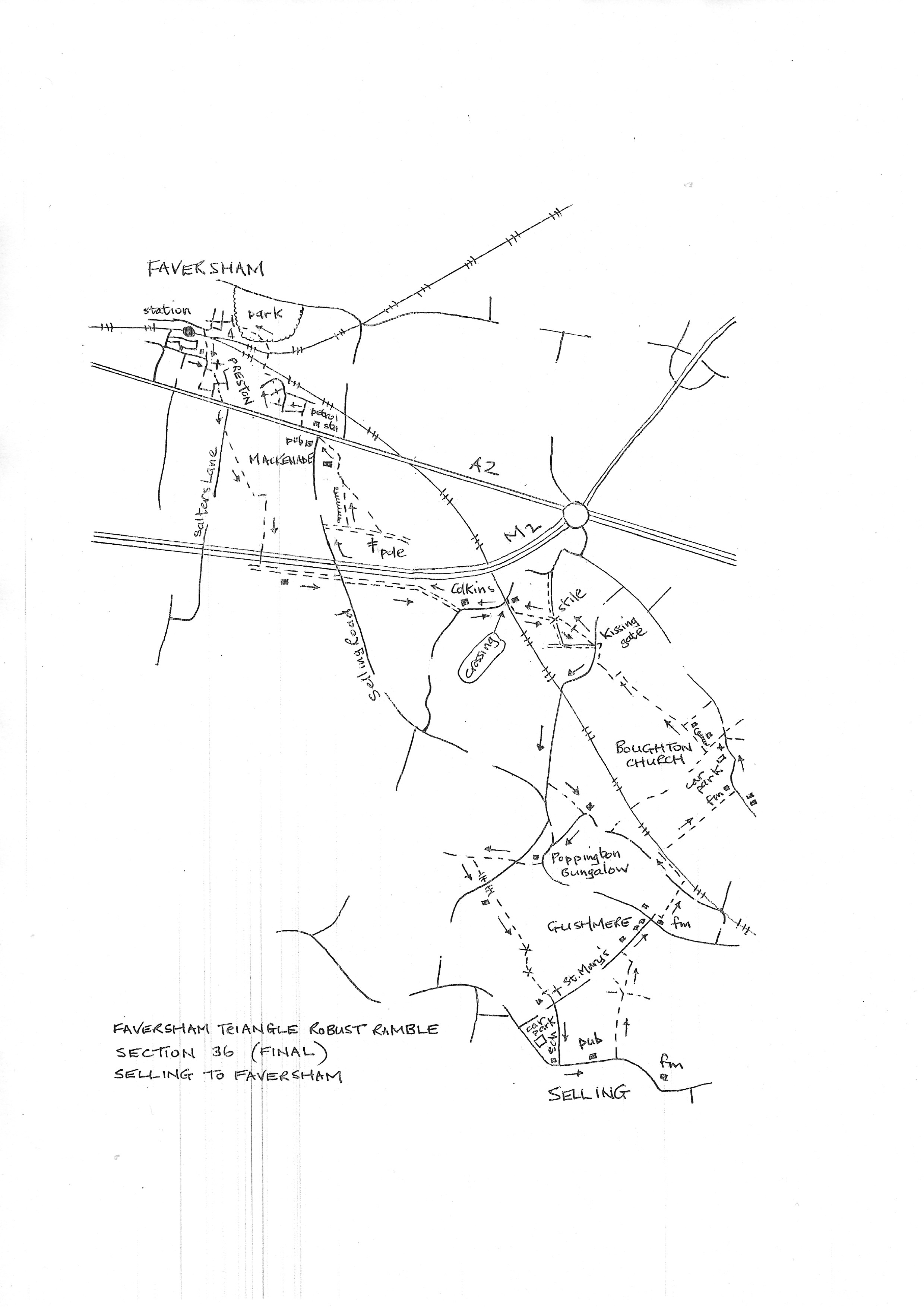
Section 36
Selling to Faversham
Walk Details
Walk Instructions
Robust Ramble – Kent Triangle - Faversham – Wadhurst – New Romney – Faversham
Section 36 Out
Selling to Faversham
OS Map: Explorer 149 Sittingbourne & Faversham
Total Circular Distance: 8 miles/5 hours
Start: From The White Lion (excellent food) in Selling, limited on-street parking, or ask at the pub. There is a large car park at the bottom of the hill on the west side of the village.
Comment: The countryside from Selling is a joy. Well-cultivated but a mix of crops with hops, blackcurrants and orchards as well as cereals. With undulating landscape, distant views are constantly revealed even across to the sea. Splendid medieval churches and oasts. Very few stiles and many metal kissing gates. Closer to Faversham, the paths do not link well and the M2 motorway removes flexibility. Thus, it’s necessary to use a track alongside the motorway for both the outward and return routes. Several short stretches of road walking on quiet country sideroads and residential roads near the station in Faversham.
With the White Lion pub in Selling behind, turn left on the road, downhill. Ignore a footpath off right and soon pass Selling Court also on your right. The road reaches a righthand bend.
Here turn left through a metal kissing gate and go forward on a grassy track. Through the next metal kissing gate reach a junction of ways. Continue straight ahead with a hedge of trees on your left and a wire fence on the right.
At a corner, follow the path left through two metal kissing gates to a road. Turn right on the road to reach a T-junction in the hamlet of Gushmere.
Go straight across to enter an enclosed path with a farm on your right. Soon emerge into a large field planted with hops, currants and excellent views. Bear right a short distance to a corner then left on a farm track down the edge of the field with a hedge on your right.
At the bottom exit through double metal fieldgates onto a narrow road.
Cross and go straight down the edge of a hop garden, a short distance, to a railway line. Turn left along the bottom of the field with the railway on your right.
At a corner turn right through a metal kissing gate and cross the railway with care. Go straight on down the field at the far side.
The path has been diverted to avoid Boughton Church Farm on your left and simply goes straight downhill to the bottom of the field. Go through the hedge onto a drive and follow it to the right then down to a road at the bottom.
Turn left on the road with care and follow it around a zig-zag then upto Boughton Church in the hill. Stay on the road to reach the main lychgate entrance into the churchyard (it is possible to turn into the church car park and go up through the graveyard to the church, to avoid some roadwalking).
Go through the lychgate (no signs here) and walk along passing the church on your left. At the far side leave the churchyard through a wooden kissing gate.
Here turn right along a hedge and garden on your right (ignore the obvious path going straight downhill to a black metal kissing gate and footbridge at the bottom).
Keep straight on down to the valley bottom then up through orchards by a hedge to reach a fence with a road the other side.
Turn right for ten metres to a fieldgate entrance and exit onto the road. Turn slightly right and cross to a metal kissing gate in the corner of a pasture.
Bear diagonally left across the centre of the pasture toa wooden fieldgate at the far side. Go through and turn left, initially along the edge of the pasture then on, across to a stile at the far side.
Cross to a drive. Go forward across this and on down a field edge, keeping trees on your left, all the way down to a white house.
Pass the house on your right and reach a railway. Turn right along by the railway with the side of the house (a former crossing keepers house) on the right. Exit onto a road.
Turn left on the road over a level crossing. And keep ahead down the road. Pass an impressive house called Colkins.
Just past this house, turn right off the road, up a concrete farm track for ½ mile.
Eventually reach a road. Turn right over a motorway bridge. In 200 metres, where the road narrows, turn right through double metal fieldgates onto a concrete farm track.
In 100 metres, just before a wooden telegraph pole, turn left onto a field edge path and keep forward along with a line of trees on your left for ¼ mile (the official path goes off left some way beyond the telegraph pole and comes diagonally back, up and across the field, to join the current path some way ahead. Local walkers are staying along the field edge)
Pass farm buildings at the top end then jig left, between fences to emerge at a corner of the car park of the Mackenade Food Hall. Keep forward on a very narrow enclosed path parallel with the edge of the car park.
Emerge onto the A2 main road and turn left. Cross a side road (Selling Road) and pass the Gunpowder Mill pub on your left. In a short distance along the main road, pass a petrol station on your right. Cross the road with care to a tarmac path off right into houses.
Go through concrete bollards and immediately turn left down a cul-de-sac. Follow the road around to the right, then left along Russet Avenue. In 10 metres turn right on a footpath between fences. Follow this to a road.
Cross and go forward to a very long footbridge over railway lines. Drop down into a park at the far end. Turn immediately left.
Go along to a corner by oasts. Exit the park through iron bollards. Turn right on a road, then first left into Chapel Street, then first left again into St. John’s Road.
Follow this up and around right to meet St. Mary’s Road. Turn left a few paces left to a corner. Look left to a footbridge over the railway signed to Preston School Room.
Cross the railway into Preston churchyard. Pass the School Room on the right and the church on your left. Turn right through the main entrance of the churchyard onto Preston Lane.
Go straight ahead down the road to reach the exit from Faversham Station car park on your right and the end of the section. This is also the end of the FAVERSHAM TRIANGLE around Kent walk. CONGRATULATIONS !
Colin Bridge 2/5/2023
Robust Ramble – Kent Triangle - Faversham – Wadhurst – New Romney – Faversham
Section 36 Return
Faversham to Selling
OS Map: Explorer 149 Sittingbourne & Faversham
Total Circular Distance: 8 miles/5 hours
Start: From the upper level of Faversham Station car park at the southern side of the station. Parking (paid) in the car park.
Comment: Interesting start through the former village of Preston to meet the old A2 road through the town. Once over this, it’s quickly into the country (although this area is threatened with residential building). The paths are easy to follow upto and over the M2 motorway. Then a long section of track follows the motorway for nearly a mile to the hamlet of Brenley, this track is used on the outward section as there is no obvious alternative. Thence ½ mile of quiet road to find steeply undulating paths into Selling. Again with some stunning views. Only one stile all the way.
From the upper level of Faversham Station car park find the vehicle exit onto Preston Lane. Turn left. Pass Preston Grove on the right and keep on towards the ancient church. Follow the road to the right past the entrance gates into St Catherine’s Drive.
Soon turn first left into a cul-de-sac. At the end keep forward down a tarmac path.
In a short distance, turn right on a path between houses and keep on up to a main road visible at the far end; cross a residential road halfway.
Turn left on the main A2 road for 30 metres. Cross and turn right up Salters Lane. Pass a football club entrance on the left, and in a few paces more, turn diagonally left on an enclosed footpath. Keep forward for ¼ mile.
At a field corner turn left, then in 10 metres, turn right up a line of trees towards the distant motorway.
In the top corner climb a ramp to cross the motorway on a bridge. On the far side, immediately turn left on a gravel driveway with the motorway on your left.
In ¼ mile reach a junction with a road. Cross over, to continue on a concrete farm track for ½ mile.
Halfway along, stay on the track as it veers away from the motorway and finally drops down to a road by an impressive house called Colkins.
Turn left on the road to reach a railway crossing. Over the crossing turn sharp right to a narrow path between a house on your left and the railway on your right.
Soon emerge into a field and continue along the edge, away from the railway, with a hedge of trees on your right.
Reach and cross a drive to a stile and continue forward to a wooden fieldgate ahead. Through this bear diagonally right across a pasture to the far opposite corner. Go through a metal kissing gate onto a road. Turn right on this road for ½ mile.
Halfway along, cross the railway, then, in 200 metres, look for a footpath off left. Follow this down a field edge, then through trees to emerge onto a road.
Follow the road uphill to a T-junction. With care, turn left and drop downhill for 50 metres. At the bottom, turn right at Poppington Bungalow onto a bridleway across the bottom of the garden. Keep forward, up through trees to a road.
Go straight over the road and on up the bridleway, enclosed by bushes and trees. At the top, where the foliage suddenly opens out, look for a narrow footpath off left through the hedge into a field.
Go diagonally left, down and across the field – views again.
At the bottom go steeply down massive steps to a road. Cross with great care and continue down on further steps. The path starts to rise, enclosed in trees.
Emerge into a field and continue straight across. Go through a hedge and continue to another. Cross the corner of this third field to a gap with metal kissing gate in the hedge.
Go through and turn sharp left, diagonally up the pasture towards a church at the top.
Emerge through a metal kissing gate onto a drive by a house. Go straight down, passing the church on your left to reach a road. Cross to the rising road opposite.
Go up then on, down, past a school to a T – junction. Turn left up the road to soon return to the White Lion and start of the section.