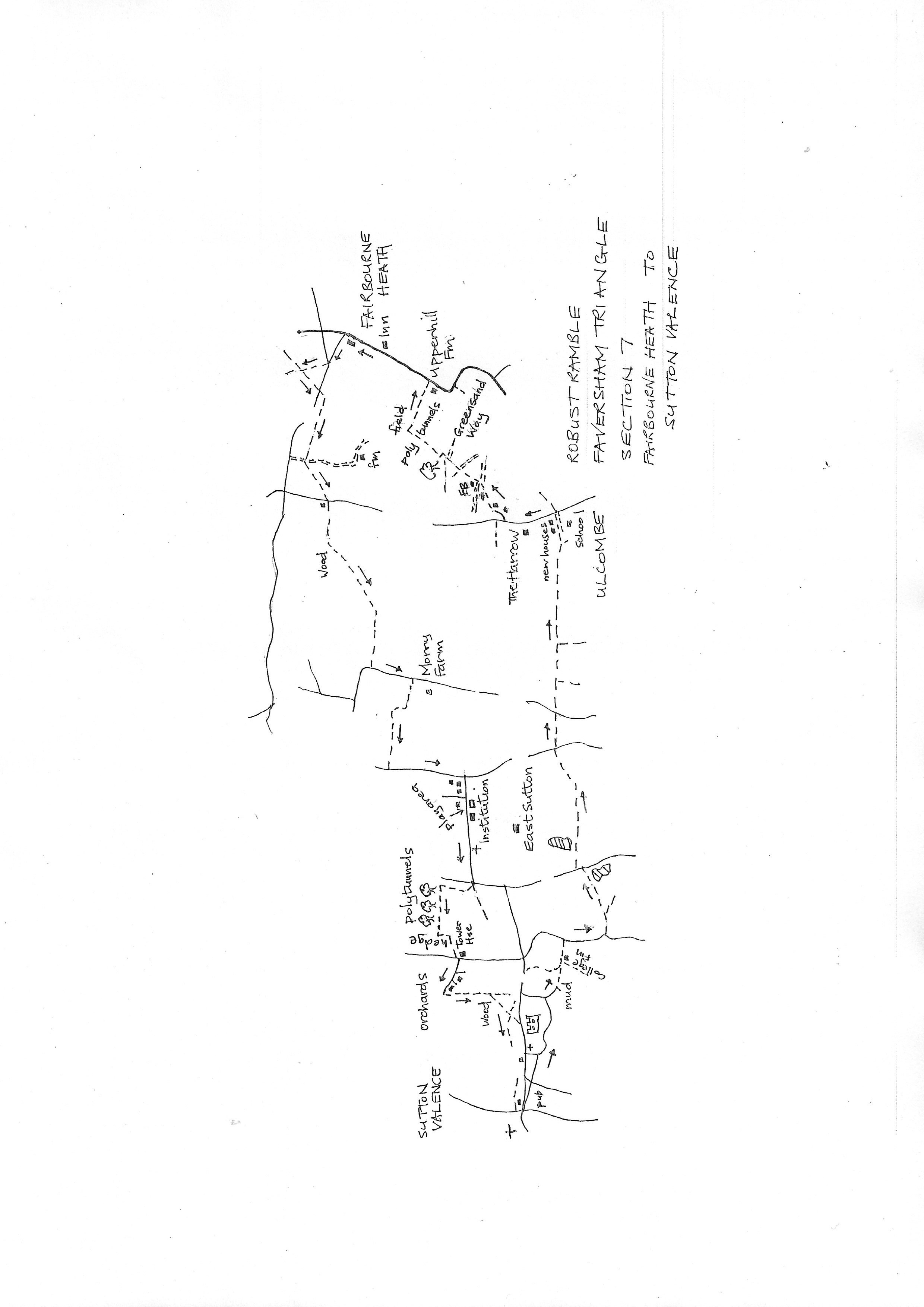
Section 7
Fairbourne Heath to Sutton Valence
Walk Details
Walk Instructions
Robust Ramble – Kent Triangle - Faversham – Wadhurst – New Romney – Faversham
Section 7 Out
Fairbourne Heath to Sutton Valence
OS Map: Explorer 137 Ashford
Total Circular Distance: 9 miles (5 hours)
Start: The Pepper Box Inn at Fairbourne Heath some on road parking or ask at the inn.
Comment: A walk of contrasts with varied countryside, but entering orchards and polytunnel country. In places paths are not clear across orchards so attention to map reading and instructions is essential. Some roadwalking on country lanes so watch for occasional traffic.
With the Pepper Box Inn on your right, go forward up the road. Just past cottages on your left, turn left on a side road. Where this meets a main road, cross, with care, to a bridle path opposite into woods.
Walk up though sweet chestnuts to reach a gravel cross path beneath two tall trees. Turn left on this gravel path to meet a metal barrier leading to a main road. Cross, carefully, to a footpath opposite.
Go down an enclosed path between bushes, to a metal kissing gate by boulders. Turn right here, over a farm track, to walk down between polytunnels, parallel to the main road over on the right.
At the far end, exit onto a drive and turn left for 20 metres, looking for a path turning right, up a bank, into a field. Bear diagonally left across to the far opposite corner. Exit through a gap into a road.
Bear left a few paces then right, up a gravel drive and over a stile into a rough, enclosed path by a wooden fence.
Cross a stile at the end and go forward towards a wood. Just before, bear left through a gateway and go on, following the wire fence along the edge of the wood over on your right.
Cross a new stile and continue by fence and wood. Where the wood ends, bear left, still along the fence and a high bank, around to a corner. Cross to a metal kissing gate and go forward, along the edge of the field with a hedge on your right.
At the far end, go through a gap to a road. Turn left for 100 metres. Just before Morry Farm, turn right on a footpath at the top of a pasture. Follow the hedge on your right. Keep by it as it bears sharply right, then left again in the top corner of the field, passing an old water bowser.
Keep on around the top edge of the field, a short distance, to a stile. Cross and keep forward with a wire fence on your right. Cross a further stile by a barn leading out to a road.
Turn left down the road for some way to a to road turning off right. Turn along here passing a children’s play area, a secure institution and a church. Reach a T-junction.
Cross to a field edge where two paths diverge. Turn right, up along the edge of the orchard (the path should go diagonally right across the orchard but has not been reinstated). Keep left around the top edge.
Continue for some way along the top edge of the orchard and continue on to the very end at a beech hedge. Turn left down the side of the hedge.
Soon reach a corner then turn diagonally right across the open to a road, just right of a large house (Pleasant House) with a tower.
Turn left a few paces, then right, up a farm road. Stay on this farm road ignoring side tracks. Bear slightly right as it passes buildings on your left and a high hedge. At the very end it reaches a metal fieldgate into an orchard.
Go through and turn left down the side of the orchard. At the bottom corner go through a metal gate into a wood.
At a Y-fork soon reached go right and then left at the next fork. Emerge into a grassy public area. Keep straight down the edge to the bottom and find steps down to a car park and road.
Turn right along the elevated pathway into Sutton Vallence, passing a former church on your left and The Swan pub, now closed on your right. Keep on along the road, passing the Queen’s Head to a T-junction. The King’s Head is on the right and the end of the section.
Robust Ramble – Kent Triangle - Faversham – Wadhurst – New Romney – Faversham
Section 7 Return
Sutton Valence to Fairbourne Heath
OS Map: Explorer 137 Ashford
Total Circular Distance: 9 miles (5 hours)
Start: The King’s Head pub in Sutton Valence. Parking available on edge of village near the castle.
Comment: A walk of contrasts with varied countryside, undulating with woods and open fields. Many polytunnels, orchards, striking houses and distant views. Enclosed paths may be overgrown and expect stiles in a range of conditions. There are significant gaps in waymarking. North of Ulcombe needs careful attention to instructions.
From the King’s Head pub walk back into the village towards the castle. In the centre, facing a converted church, turn right, downhill, signed for the Castle.
At a T-junction turn left up Rectory Lane. Pass the castle and stay on the lane. Ignore a footpath off right. Follow the road as it climbs up then drops down to a T-junction on a bend.
Turn right, down to Stallance Farm. Where the road ends at the farm entrance, go straight on into a very muddy enclosed track by a wire fence on the right. Horses and a spring make this potentially a difficult stretch. Emerge on a farm track at College Farm.
Pass College Farm on your right and keep forward along a rough roadway to a road junction. Turn right downhill for 100 metres.
In an S-bend look for a footpath off left through a metal kissing gate in the hedge. Enter the corner of an orchard. Go straight ahead along by the hedge on your left.
Keep on for some way. At the bottom end of the orchard, go through a gap in the hedge. Keep on along the bottom of a further orchard with a reservoir on the right, to reach a gateway and road beyond.
Turn left up the road a few paces, then right on a footpath through a metal kissing gate. Go forward with a hedge on your left. Reach and cross a footbridge into woods.
Climb up the wood to its top edge and a metal kissing gate. Enter more orchards. Go forward, slightly left, on a muddy track between orchards.
At the bottom cross a stile by a metal fieldgate and continue up the right side of an open grassy pasture to a corner of trees (this is a steeply sloping field with good views). Pass the trees and an orchard behind a wire fence on your right. At the very top corner, exit through a metal kissing gate onto a road.
Cross and go through gates to continue forward by the fence on your left. Cross a footbridge go up the field to gates onto a road.
Cross and continue (basically for a mile into Ulcombe).
Ignore footpaths off right as you go and pass between large strawberry fields. Continue passing woods on your right and a reservoir on your left.
On reaching an orchard on your left, bear left on a footpath up through the orchard. At the top, bear left a few paces, then right over a footbridge and metal kissing gate into a sloping field.
Bear left along by the hedge on your left and exit onto a drive by new houses. Continue down to the main road in Ulcombe.
Turn left up the main road to pass the old pub ‘The Harrow’ (seemingly reopened as a restaurant and bar). Keep on uphill a short way further to turn right into a close called Street Field.
At the top end join a grassy way up to a swing gate by a metal fieldgate. Cross an open grassy space to a stile into a wood.
Soon emerge onto another grassy space. Cross to a narrow, enclosed path in the opposite corner. This is a very odd place and a bit difficult to traverse.
Emerged onto a drive. Ignore a broken stile opposite and turn right a few paces to the very end of the drive. Either go through a tiny garden gate or, slightly left, through a black mesh gate past a quirky wooden shack to a footbridge. Cross and go up an overgrown path to a metal kissing gate.
Two paths leave here. Bear left up the side of the field, parallel to the hedge on your left, but bearing gently right and uphill.
Go though an obvious gap in the hedge ahead and keep on gently up and slightly right. Near the field end meet a grassy cross path (The Greensand Way).
Turn right on this, up to a metal kissing gate in bushes at the top. Emerge into the bottom of an orchard.
Leave the Greensand Way and turn left for a short way along the bottom of the orchard, then turn steeply uphill, still along the orchard edge.
At the top corner, soon reached, ignore a horse ride arrow off right. Instead go forward, up between polytunnels.
At the top, climb steps in the bank, into a large open field. Continue up the open field. In the middle turn right towards a farm. Cross a stile and go down past farm buildings to emerge onto a road at Upperhill Farm.
Turn left and walk up 100 metres to return to the Pepperbox Inn and the start of the section.