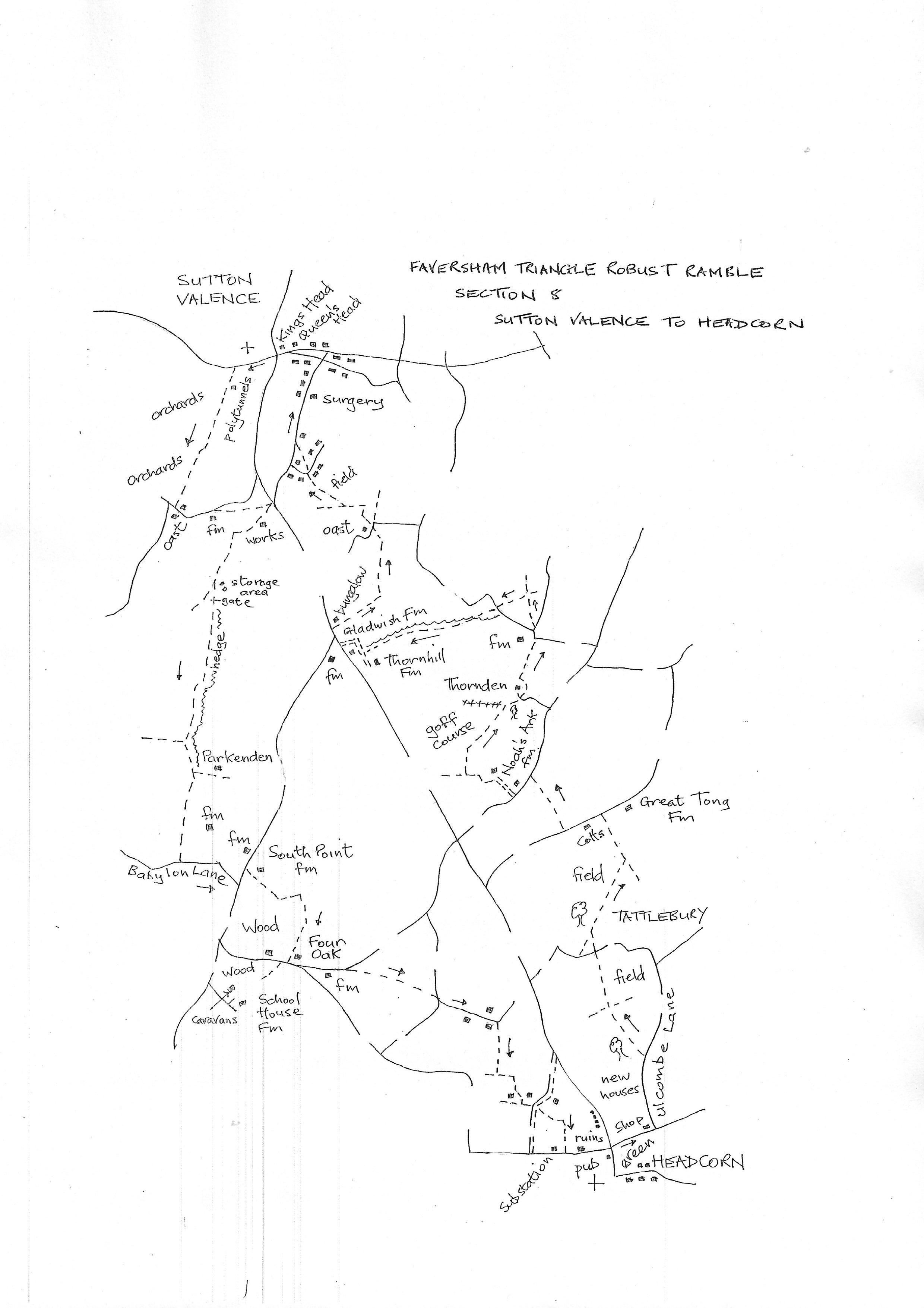
Section 8
Sutton Valence to Headcorn
Walk Details
Walk Instructions
Robust Ramble – Kent Triangle - Faversham – Wadhurst – New Romney – Faversham
Section 8 Out
Sutton Valence to Headcorn
OS Map: Explorer 137 Ashford & 136 The Weald
Total Circular Distance: 9 miles (6 hours)
Start: The Kings Head, Sutton Valence; parking available further back in the village
Comment: A walk with some good views and plenty of country, but some heavily mechanised cultivation and polytunnels. Some of the paths are not apparent on the ground and often not waymarked. The long section past Parkenden is an example. There are fieldgates to climb and stiles, often broken. The ground is very demanding either when very dry or very wet. Allow plenty of time.
From the King’s Head, carefully cross the road to Chart Road opposite. Walk up this road looking for the first footpath off left. Pass the church up on your right.
The path goes down the entrance drive to West Bank Cottage and is a wide asphalt vehicle drive.
The drive ends by the house. Go on into an enclosed path dropping steeply down past polytunnels on your right. Then continue with polytunnels on the left to reach farm buildings.
Bear right back onto an enclosed path which passes farm buildings, static caravans, then polytunnels to a Y-fork.
Turn right through bushes to an orchard. Turn left down the side. Keep on down towards an oasthouse. The path doesn’t go directly to it so bear over towards it and exit onto a road.
Turn left on this road for a short way. Pass farm buildings on your right and come to a footpath off right.
Turn into the footpath then bear diagonally left past the end of a cowshed to a footbridge. Cross and go over to a second footbridge. Go up the edge of the field ahead to the very top corner and cross a stile onto a vehicle track.
Turn right on this, past a water treatment works, and down to a metal fieldgate. Go through to a T-junction. Turn left on a rougher track through another gateway.
In 100 metres reach a Y-fork. The main track bears right and reduces in size. On the left is a farm storage area. Cross this to two rusty metal fieldgates in the far corner. There is no stile or waymarks. The gates have to be climbed.
Once over, go down the edge of a massive field for ½ mile. Keep by the ditch and straight hedge on your left all the way down to the bottom corner. Here cross a stile in the hedge. Keep on in the same direction.
Look for a footbridge on your left and cross into a field. Here turn diagonally right and cross the field to the far opposite corner and a stile at the bottom of a farm scrapyard.
Cross the stile and basically turn right; this means going round some vehicles to a stile by a black gate into a meadow. Turn sharp left and follow hedge and ditch on your left.
At a corner cross a footbridge and a rotten old stile into a pasture. Go up the edge with fence on the right. At the end go right through a metal fieldgate, immediately left to a metal swing gate, then over a footbridge into a pasture.
Turn immediately right along the field edge and find a swing gate by a metal fieldgate. Continue, now with a hedge on your left.
At the end, cross the only decent stile of the day onto Babylon Lane. Turn left to a T-junction. Here turn left up the main road, a short distance. Pass the buildings of South Point Farm, then turn right up the farm entrance.
Pass the farmhouse on your left and continue on the main track through the farm buildings and through a swing gate at the far side. Continue on the main track as it and the hedge curve right. Look for a pair of old green metal fieldgates on your left.
Go through and up the field edge to two more fieldgates in the top corner. Pass into the next field and turn diagonally right down across the centre to a footbridge in the bottom hedge.
Cross into a large field and go straight ahead down towards farm buildings at the bottom.
On reaching the buildings at Four Oaks, join the farm entrance drive and go down to a road. Turn left on the busy road. At a Y-junction, bear left for 100 metres, passing old farm buildings on your right.
Reach a footpath off right at a massive green barrier gate. It very likely opens but it may have to be climbed.
Bear sharply diagonally left, up and across the field, to a footbridge near the top corner. Cross into the field ahead.
Go diagonally left across the centre of the field to the far opposite corner and a broken stile by a metal fieldgate. Cross onto a road junction. Do not turn left or right but go straight ahead up the narrow road ahead, for 100 metres.
Immediately past the last row of cottages on your right, turn right down a gravel drive past the end of the terrace. Reach a metal kissing gate into a field. Turn right up the edge with a hedge on your right. Halfway along, turn right over a footbridge into the adjacent field and immediately left up edge with hedge on your left.
Cross and go diagonally right across the centre of the field to a wooden swing gate in the top corner. The path is difficult to follow now with no waymarks.
Through the gate go up the next pasture to another wooden swing gate. Turn left to a further wooden swing gate and go down the side of a tennis court. Exit through a gate, and in a few paces go left through a metal gate and down a drive to a T-junction.
Cross to a wooden fieldgate opposite and enter a field. Go diagonally right across the centre and down the field to a stile in the bottom corner.
Keep along the top edge of the field ahead to a further stile (bluebells to be seen but no waymarkers). In the final field turn right and walk down, aiming just left of an electric substation in the bottom corner. Exit carefully onto a busy road. Turn left along to a crossroads and traffic lights in Headcorn. The White Horse pub is immediately on your right at the end of the section.
Robust Ramble – Kent Triangle - Faversham – Wadhurst – New Romney – Faversham
Section 8 Return
Headcorn to Sutton Valence
OS Map: Explorer 137 Ashford & 136 The Weald
Total Circular Distance: 9 miles (6 hours)
Start: The White Horse in Headcorn. Parking very difficult, though on-street opposite sometimes possible.
Comment: This is a really tough trek with heavily ploughed fields to start with then the usual problems over a golf course at Thornden. There follows little used paths that are difficult to follow and a steep climb back up to Sutton Valence. Be prepared !
From the White Horse, cross the road to the grassy area opposite and walk up, bearing left, to the top left corner.
Turn right up the road, then first left into Ulcombe Lane. Continue for ¼ mile, past new housing on the left, then look for a footpath off left through a gap in the hedge into a field corner.
Go along the field edge then on, slightly right, across the open field past a lone wooden pole. Keep on across this huge field to a stile by a pond at the far side. Exit onto a road. Cross to a footpath opposite.
Walk a short distance across a field to a T-junction of paths before trees. Turn right. At the end of the treeline ignore a path off left and continue straight ahead across the open field towards a green barn in the distance.
At the far side turn left up a wide track. At the top of the slope reach a junction with a farm drive. Turn left past cottages on your left.
In 20 metres, look carefully in the hedge on your right for a wooden swing gate in the hedge and go straight down a field by a wooden pole. Continue in a straight line to a stile in the final hedge onto a road.
Turn left along road for 50 metres, looking for a footpath off right up the concrete drive to Noah’s Ark Farm. By an oast on your right, bear left, still on the track, round the farmhouse, to reach a golf course.
The usual difficulties with following the route. Go ahead for 15 metres, then turn right over a ditch, then immediately left for 15 metres along the top of the ditch.
At this point (there is a waymark post), turn right, uphill through trees for some way. At the top bear right on a gravel path to a junction of paths. A way mark post seems to indicate continuing pretty much in the same forward direction as before.
This path continues to the very top of the course. Here turn right with care, keeping to the top edge, to go towards a line of trees. On reaching them, look for a wooden gate and stile hidden in the hedge on your left.
Cross out of the golf course, and turn immediately right over to a drive. Turn left a few paces then right over a new stile by a wooden fieldgate into a field. This is a path diversion around the house to pick up the path at the rear. So turn left and follow the fence around the house to a metal kissing gate in the corner at the back. Go through and straight on.
Cross a pasture to a metal gate and footbridge, then on down a further pasture to a stile onto a road.
Turn left a short way to a junction. Cross, slightly right, to a stile. Enter a large field and bear diagonally left (if no path is reinstated) across to a lone tree at the fence at the far side. Turn left along with fence on your right, to a stile out to a road.
Cross to a broken stile (metal fieldgate just right if easier to climb). Enter a field and follow the stream on your left. Soon cross a bridge on the left over the stream and turn right along parallel to the stream now on the right.
At the end of the field go through a rusty metal fieldgate and turn sharp right, still along by the stream. Go through a new metal fieldgate and on by the stream. Then through a gap into the final field with farm buildings beyond.
Stay very close to the stream, to exit field by a metal gate tight in the corner below the farm buildings. Enter an enclosed path close to the stream and emerge at a crossing of ways.
Turn right over a bridge up towards oasts. Pass them on your left and follow the drive around to a busy main road.
Turn right up the road for a short distance. There is a narrow verge but take great care. Just past a turning off left, turn right, off the road over a footbridge by a bungalow. Go on to join an enclosed path.
Soon cross an open field to a metal kissing gate. Continue by the fence on your left and wind round to a double stile in the far corner.
Cross into a rough area. Go straight ahead. There is a pond in trees. Go up the side of the pond with a bank on your left. Reach a broken stile.
Go up by hedge, then over an open field aiming just right of an oast. Exit onto a road over a broken stile.
Cross to the start of two paths. Take the one on the left through a metal fieldgate and cross to a stile. Turn right on an enclosed path around the perimeter of a paddock.
At the bottom of the slope at the far side, turn right over a footbridge, then bear left diagonally up the centre of the field by a lone tree (ignore footpath following bottom edge of field).
At the far side cross a footbridge into an enclosed path leading to a road. Cross and go up the alleyway opposite.
Emerge onto a road. Turn right up it for ¼ mile steeply uphill into Sutton Valence. At the top turn left to pass the Queen’s Head and finally reach the King’s Head on the main road and the start of the section.