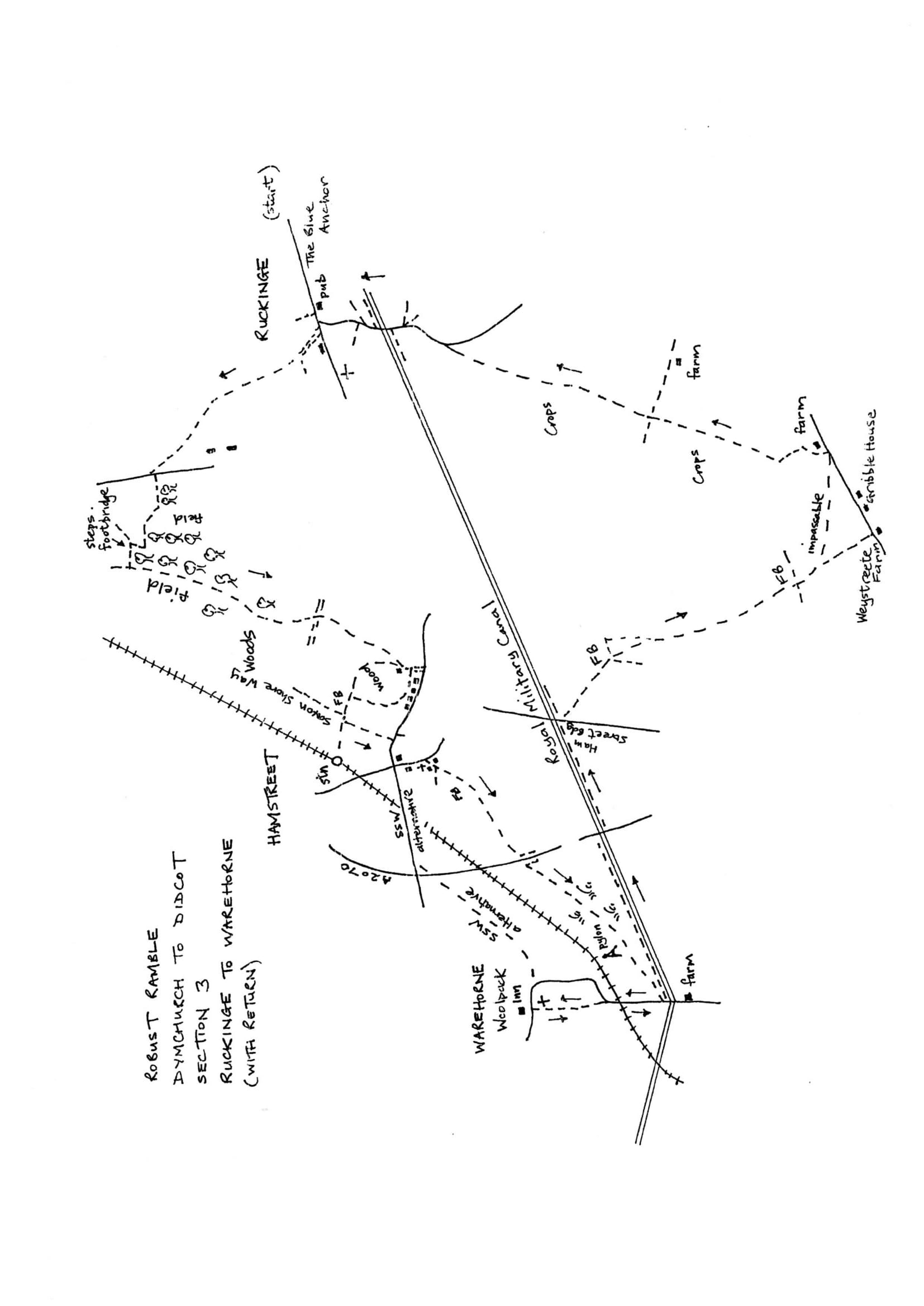
Section 3 Out
Ruckinge to Warehorne
Walk Details
| Map | OS Explorer 125 Romney Marsh |
|---|---|
| Distance/Time | 4 miles/ 2 hours |
| Start | Main road in Ruckinge village centre, at Blue Anchor pub building |
| Comment | A walk of contrasts from marshland to woodland with moments of wide ranging views. It does, however, explore paths not in regular use and not in evidence over rough terrain. Woodland paths are not well waymarked and can be confused with other paths and tracks. There are many stiles, some in poor condition. A big decision needs to be made about the last section. The A2070 bypass road is very busy with very fast traffic. Rush hours, Sundays and Bank Holidays may generate extra traffic. If in doubt take the alternative suggested route. |
Walk Instructions
With the Blue Anchor pub on your left, go ahead downhill a short way. Where a side road goes off left turn right up a wide driveway. At the top cross a stile into a field and go up under power lines to a broken stile at the top. Cross into the next pasture and continue up in the same direction.
Keep along the fence on your right to a stile and footbridge in the corner by oak trees. Go forward in the next field to a stile at the very top. There are excellent views here across the marsh.
Again go forward down a sloping meadow below a tennis court. Find a further stile and footbridge at the far side. Cross, to go along by a garden to another stile. Bear diagonally left up a large field to the top lefthand corner.
Here cross two stiles to reach a road. Cross the road to a hidden, old and shaky stile. Cross into a field. The path has been diverted from the OS map. Do not bear off right but go straight ahead down the side of the field with a treeline on your left. Where the trees end, bear right, diagonally across the corner of the field, to a corner of woodland. Here go on along the edge of the field with woods on your left, down to a corner then right along the bottom side of the field.
In 50 metres look out for a path leaving the field left down steps to a footbridge in the wood. Cross this and scramble up the other side into a field. Go ahead along the edge of the field, still with woods on your left. At a corner turn left, still along the edge of the woods, for some way.
Towards the end of the field it narrows and eventually finishes in a small boxed-in square. Here cross the square diagonally right to the far opposite corner. Climb a low wire fence to enter the woods. Keep forward on a definite path soon going under power lines and reach a byway. Cross this to a metal kissing gate and go on into Ham Street Woods Nature Reserve. Go forward generally downhill on a clear path through the woods. After some time cross a horse track and keep on as before, to reach a metal kissing gate at the edge of the wood. There are excellent views here across to Sussex.
Cross the field ahead aiming right of houses in the distance. Leave the field by a metal kissing gate and keep forward a few paces down a grassy track.
Just before a garage, turn sharp right back into Ham Woods. Go straight ahead on a path skirting gardens on the left. Stay on this path a good distance ignoring paths going off left into housing. The path drops down then bears right and swings uphill again. Keep on for a good distance.
Eventually reach a junction of paths in a clearing. Turn left here, down to cross a wide bridge and enter the car park beyond. Turn left through the car park on what is now the Saxon Shore Way.
Follow this roadway down to a T-junction with a main road by a green and shops on the left. Turn right and follow the road along to a major crossroads by the Duke’s Head pub in Ham Street.
The next section to Warehorn involves a flat crossing of the busy A2070 and walking across an area that can be marshy in wet weather. Those wishing to avoid this may stay on the Saxon Shore Way to the end of the section at the Woolpack pub at Warehorn. To do this, from the Duke’s Head go straight across the crossroads and follow the waymarks.
To continue this robust ramble, turn left at the Duke’s Head downhill past a general store and a church on the right. Just before the last house on the right and a car park beyond, turn right on a driveway between houses. Soon reach a Y-fork. Go to the left along past a house, allotments and a water pumping station. Keep going to a footbridge.
Cross and go through two metal swing gates into a rising field. Go on up the field edge. Where the fence on the right ends, keep forward uphill. At the top enter a further field and bear slightly left over it, to a line of bushes at the far side by a busy major road.
At the far side cross a stile and go left down an enclosed path to a set of steps up to the road side. WAIT PATIENTLY FOR A LONG CLEAR BREAK IN THE TRAFFIC; IT TRAVELS AT MOTORWAY SPEEDS then cross to the other side. Descend steps to another enclosed path and follow this to a stile.
Enter a field and bear diagonally left downhill past a wooden pole to the far bottom corner. Here cross a stile into a large reedy pasture. Go forward, parallel with the railway over on the right, aiming for the highest pylon straight ahead. In midfield there is an old footbridge.
Cross this and turn right, to go on in the same direction, towards the pylon, with an old silver van body in front. This area is marshy although fine in dry weather.
When Warehorne church suddenly appears up on the right, find a small two plank footbridge. Cross and keep on to a stile, just in front of the van body.
Cross the stile and go forward. Bear left to pass the pylon on your right. Keep parallel with the hedge on the left, across to a stile in a fence ahead. Cross this into a large field. Keep forward, heading right of farm buildings in the distance. Eventually reach a stile by a metal fieldgate and exit onto a road.
Turn right up the road. Soon cross the railway and keep forward to a righthand bend. Here bear left into a house entrance to find a concealed footpath that goes up to a stile.
Cross into a rising pasture with the church at Warehorne ahead. Keep left of the church and find a small gate at the base of the church tower. Go through and forward to drop down through the churchyard to a road with the Woolpack Inn opposite and the end of the section.